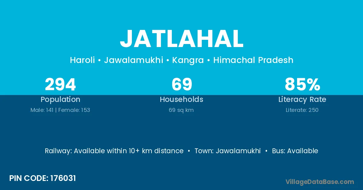
Jatlahal village is located in the Jawalamukhi Tehsil of the Kangra district in Himachal Pradesh .
Block / Tehsil → Jawalamukhi
District → Kangra
State → Himachal Pradesh
According to Census 2011 information, the village code of Jatlahal village is 176031.
Jatlahal village has a total population of 294 people, of which 141 are males and 153 are females.
The literacy rate of Jatlahal village is 85.03%. Male literacy stands at 92.20% and female literacy at 78.43%.
There are approximately 69 households in Jatlahal village.
Jawalamukhi is the nearest town to Jatlahal village for major economic activities
The population of Jatlahal village is distributed between literate and illiterate residents as follows:
| Particulars | Male | Female | Total |
|---|---|---|---|
| Literate | 130 | 120 | 250 |
| Illiterate | 11 | 33 | 44 |
| Total | 141 | 153 | 294 |
Source: Census 2011
| Village | District |
|---|---|
| Bahl | Bilaspur |
| Bahl | Hamirpur |
| Bahl | Hamirpur |
| Bahl | Hamirpur |
| Bahl | Hamirpur |
| Bahl | Kangra |
| Bahl | Kangra |
| Bahl | Kangra |
| Bahl | Kangra |
| Bahl | Mandi |
| Bhuvitar | Kangra |
| Darang | Janjgir Champa |
| Darang | Kangra |
| Darang | Jaintia Hills |
| Doli | Panch Mahals |
| Doli | Kangra |
| Doli | Kangra |
| Doli | Solan |
| Doli | Damoh |
| Doli | Jabalpur |
| Doli | Alwar |
| Doli | Dungarpur |
| Doli | Jodhpur |
| Doli | Kota |
| Doli | Pratapgarh |
| Doli | Khammam |
| Doli | Ballia |
| Hiran | Kangra |
| Hiran | Una |
| Hiran | Debagarh |
| Hiran | Ludhiana |
| Kaleri | Hamirpur |
| Kaleri | Kangra |
| Kaleri | Dausa |
| Laharu | Kangra |
| Lahasan | Kangra |
| Purtiala | Kangra |
| Saletar | Kangra |
| Uchhahr | Kangra |
No reviews yet. Be the first to review this village!
Available within 10+ km distance
Available within 5 - 10 km distance
Available within village