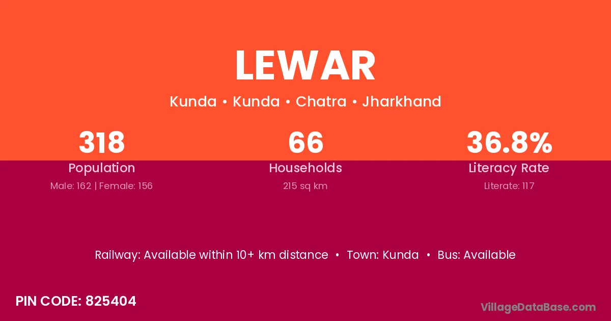
Lewar village is located in the Pahalgam Tehsil of the Anantnag district in Jammu & Kashmir .
Block / Tehsil → Pahalgam
District → Anantnag
State → Jammu & Kashmir
According to Census 2011 information, the village code of Lewar village is 192401.
Lewar village has a total population of 2,903 people, of which 1,439 are males and 1,464 are females.
The literacy rate of Lewar village is 39.27%. Male literacy stands at 50.45% and female literacy at 28.28%.
There are approximately 416 households in Lewar village.
Ashmuqam (5 km) is the nearest town to Lewar village for major economic activities and is located approximately 5 km away.
The population of Lewar village is distributed between literate and illiterate residents as follows:
| Particulars | Male | Female | Total |
|---|---|---|---|
| Literate | 726 | 414 | 1,140 |
| Illiterate | 713 | 1,050 | 1,763 |
| Total | 1,439 | 1,464 | 2,903 |
Source: Census 2011
| Village | District |
|---|---|
| Ainu Brai | Anantnag |
| Amar Wagar | Anantnag |
| Gansh Pora | Anantnag |
| Grand Aish | Anantnag |
| Hardu Kichroo | Anantnag |
| Ichi Nar | Anantnag |
| Kanz Gam | Anantnag |
| Logri Pora | Anantnag |
| Logri Pora | Baramula |
| Salar | Raigarh |
| Salar | Anantnag |
| Salar | Anugul |
| Salar | Sangrur |
| Salar | Udaipur |
| Salar | Murshidabad |
| Salar | Murshidabad |
| Wahdan | Anantnag |
| Wajoora | Anantnag |
No reviews yet. Be the first to review this village!
Available within 10+ km distance
Available within 10+ km distance
Available within village