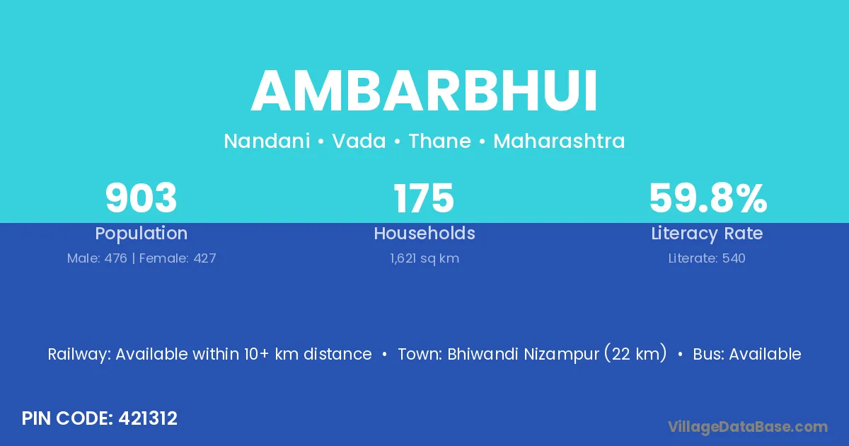
Ambarbhui village is located in the Vada Tehsil of the Thane district in Maharashtra .
Block / Tehsil → Vada
District → Thane
State → Maharashtra
According to Census 2011 information, the village code of Ambarbhui village is 421312.
Ambarbhui village has a total population of 903 people, of which 476 are males and 427 are females.
The literacy rate of Ambarbhui village is 59.80%. Male literacy stands at 68.91% and female literacy at 49.65%.
There are approximately 175 households in Ambarbhui village.
Bhiwandi Nizampur (22 km) is the nearest town to Ambarbhui village for major economic activities and is located approximately 22 km away.
The population of Ambarbhui village is distributed between literate and illiterate residents as follows:
| Particulars | Male | Female | Total |
|---|---|---|---|
| Literate | 328 | 212 | 540 |
| Illiterate | 148 | 215 | 363 |
| Total | 476 | 427 | 903 |
Source: Census 2011
| Village | District |
|---|---|
| Bilavali | Thane |
| Budhavali | Nandurbar |
| Budhavali | Thane |
| Gorad | Anand |
| Gorad | Mahesana |
| Gorad | Buldana |
| Gorad | Thane |
| Gorad | Thane |
| Gunj | Buldana |
| Gunj | Parbhani |
| Gunj | Thane |
| Gunj | Yavatmal |
| Gunj | Auraiya |
| Kati | Udhampur |
| Kati | Rewa |
| Kati | Akola |
| Kati | Amravati |
| Kati | Bhandara |
| Kati | Buldana |
| Kati | Gondiya |
| Kati | Osmanabad |
| Kati | Pune |
| Kati | Thane |
| Kati | Yavatmal |
| Kati | Yavatmal |
| Kati | Kushinagar |
| Kati | Sant Kabir Nagar |
| Kelthan | Thane |
| Lohape | Thane |
| Musarne | Thane |
| Nandani Gaigotha | Thane |
| Nimbavali | Thane |
| Nimbavali | Thane |
| Vadavali Tarf Poulbar | Thane |
No reviews yet. Be the first to review this village!
Available within 10+ km distance
Available within village
Available within 10+ km distance