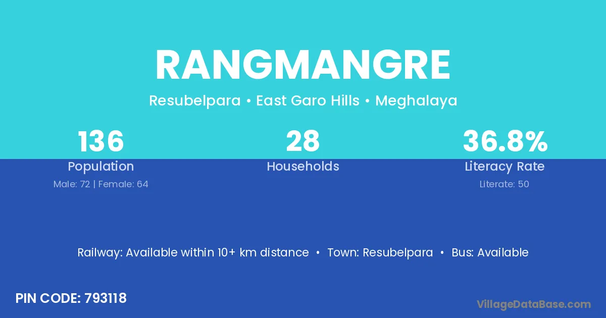
Rangmangre village is located in the Resubelpara Subdivision of the East Garo Hills district in Meghalaya .
Block / Subdivision → Resubelpara
District → East Garo Hills
State → Meghalaya
According to Census 2011 information, the village code of Rangmangre village is 793118.
Rangmangre village has a total population of 136 people, of which 72 are males and 64 are females.
The literacy rate of Rangmangre village is 36.76%. Male literacy stands at 41.67% and female literacy at 31.25%.
There are approximately 28 households in Rangmangre village.
Resubelpara is the nearest town to Rangmangre village for major economic activities
The population of Rangmangre village is distributed between literate and illiterate residents as follows:
| Particulars | Male | Female | Total |
|---|---|---|---|
| Literate | 30 | 20 | 50 |
| Illiterate | 42 | 44 | 86 |
| Total | 72 | 64 | 136 |
Source: Census 2011
| Village | District |
|---|---|
| Boda Apal | East Garo Hills |
| Jongdongre | East Garo Hills |
| Moamari | Goalpara |
| Moamari | East Garo Hills |
| Moamari | Koch Bihar |
| Moamari | Koch Bihar |
| Motcholpara | East Garo Hills |
| Pekimchak | East Garo Hills |
| Radi | Samba |
| Radi | Bid |
| Radi | East Garo Hills |
| Radi | Bundi |
| Radi | Deoria |
| Radi | Deoria |
| Rangel | East Garo Hills |
| Rangel | Saharanpur |
| Rongmatcha | East Garo Hills |
| Rongpetchi | East Garo Hills |
| Rongs Nokap | East Garo Hills |
| Songmegap | East Garo Hills |
No reviews yet. Be the first to review this village!
Available within 10+ km distance
Available within 10+ km distance
Available within 5 - 10 km distance