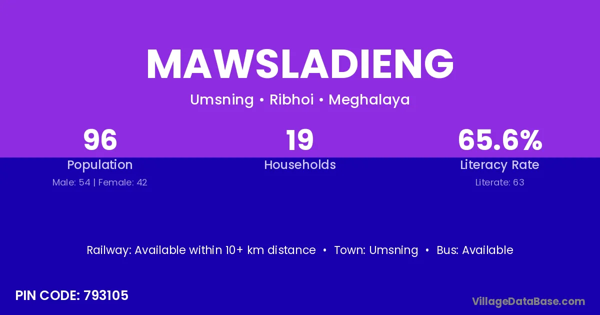
Mawsladieng village is located in the Umsning Subdivision of the Ribhoi district in Meghalaya .
Block / Subdivision → Umsning
District → Ribhoi
State → Meghalaya
According to Census 2011 information, the village code of Mawsladieng village is 793105.
Mawsladieng village has a total population of 96 people, of which 54 are males and 42 are females.
The literacy rate of Mawsladieng village is 65.63%. Male literacy stands at 75.93% and female literacy at 52.38%.
There are approximately 19 households in Mawsladieng village.
Umsning is the nearest town to Mawsladieng village for major economic activities
The population of Mawsladieng village is distributed between literate and illiterate residents as follows:
| Particulars | Male | Female | Total |
|---|---|---|---|
| Literate | 41 | 22 | 63 |
| Illiterate | 13 | 20 | 33 |
| Total | 54 | 42 | 96 |
Source: Census 2011
| Village | District |
|---|---|
| Itsopaiar | Ribhoi |
| Laru | Gaya |
| Laru | Jaintia Hills |
| Laru | Jaintia Hills |
| Laru | Ribhoi |
| Laru | Pratapgarh |
| Moiambei | Ribhoi |
| Tyrsopdeng | Ribhoi |
| Umhi | Ribhoi |
| Umlaiteng | Ribhoi |
| Umlaper | Jaintia Hills |
| Umlaper | Ribhoi |
| Ummat | Jaintia Hills |
| Ummat | Ribhoi |
| Umru | Karbi Anglong |
| Umru | Patan |
| Umru | Ribhoi |
| Umsder | Ribhoi |
| Umtngam | Ribhoi |
No reviews yet. Be the first to review this village!
Available within 10+ km distance
Available within 10+ km distance
Available within 10+ km distance