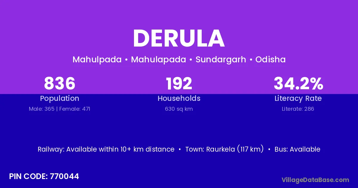
Derula village is located in the Mahulapada Tehsil of the Sundargarh district in Odisha .
Block / Tehsil → Mahulapada
District → Sundargarh
State → Odisha
According to Census 2011 information, the village code of Derula village is 770044.
Derula village has a total population of 836 people, of which 365 are males and 471 are females.
The literacy rate of Derula village is 34.21%. Male literacy stands at 34.79% and female literacy at 33.76%.
There are approximately 192 households in Derula village.
Raurkela (117 km) is the nearest town to Derula village for major economic activities and is located approximately 117 km away.
The population of Derula village is distributed between literate and illiterate residents as follows:
| Particulars | Male | Female | Total |
|---|---|---|---|
| Literate | 127 | 159 | 286 |
| Illiterate | 238 | 312 | 550 |
| Total | 365 | 471 | 836 |
Source: Census 2011
| Village | District |
|---|---|
| Angul | Bargarh |
| Angul | Sundargarh |
| Budhakhaman | Balangir |
| Budhakhaman | Debagarh |
| Budhakhaman | Subarnapur |
| Budhakhaman | Sundargarh |
| Daleisara | Sundargarh |
| Dhokamunda | Sundargarh |
| Hatisoul | Sundargarh |
| Keta | Sundargarh |
| Kiri | Chamba |
| Kiri | Shimla |
| Kiri | Pashchimi Singhbhum |
| Kiri | Sundargarh |
| Kiri | Ludhiana |
| Kundula | Sundargarh |
| Kunu | Kathua |
| Kunu | Sundargarh |
| Sihidiha | Sundargarh |
| Trijanga | Sundargarh |
No reviews yet. Be the first to review this village!
Available within 10+ km distance
Available within 10+ km distance
Available within 5 - 10 km distance