Welcome Back

Forgot password?
Don't have an account?
🏘️ Menu
Bhilwara District 0.0 / 5 (0)

Atawara Village Detailed Information

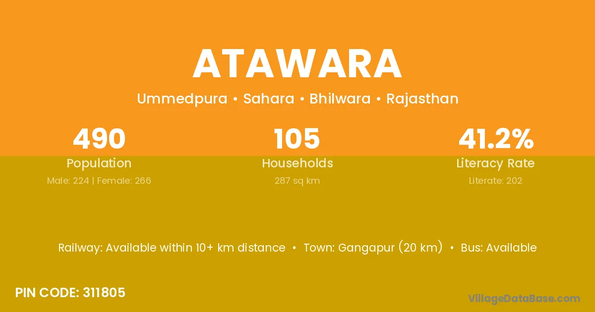
Atawara village is located in the Sahara Tehsil of the Bhilwara district in Rajasthan .

About Atawara Village

Block / Tehsil → Sahara

District → Bhilwara

State → Rajasthan

According to Census 2011 information, the village code of Atawara village is 311805.

Atawara village has a total population of 490 people, of which 224 are males and 266 are females.

The literacy rate of Atawara village is 41.22%. Male literacy stands at 53.13% and female literacy at 31.20%.

There are approximately 105 households in Atawara village.

Gangapur (20 km) is the nearest town to Atawara village for major economic activities and is located approximately 20 km away.

Population of Atawara Village

The population of Atawara village is distributed between literate and illiterate residents as follows:

Population distribution of Atawara village by literacy and gender
Particulars Male Female Total
Literate 119 83 202
Illiterate 105 183 288
Total 224 266 490

Source: Census 2011

Nearby Villages

List of nearby villages around Atawara village
Village District
Ummedpura Dhar
Arniya Indore
Ummedpura Jhabua
Ummedpura Neemuch
Ummedpura Neemuch
Ummedpura Rajgarh
Arniya Ratlam
Ummedpura Ratlam
Arniya Shajapur
Ummedpura Shivpuri
Ummedpura Ajmer
Ummedpura Banswara
Arniya Banswara
Ummedpura Banswara
Neemkhera Baran
Ummedpura Baran
Ummedpura Barmer
Neemkhera Bharatpur
Ummedpura Bhilwara
Ummedpura Bhilwara
Ummedpura Bhilwara
Ummedpura Bhilwara
Palran Bhilwara
Arniya Bhilwara
Arnota Bhilwara
Koshithal Bhilwara
Neemkhera Bhilwara
Palran Bhilwara
Surat Singh Ka Khera Bhilwara
Thekla Bhilwara
Ummedpura Bhilwara
Ummedpura Bhilwara
Arniya Bundi
Ummedpura Chittaurgarh
Koshithal Chittaurgarh
Ummedpura Chittaurgarh
Arniya Chittaurgarh
Ummedpura Chittaurgarh
Arniya Chittaurgarh
Ummedpura Chittaurgarh
Arniya Chittaurgarh
Arniya Dausa
Ummedpura Dungarpur
Arniya Jaipur
Arniya Jhalawar
Ummedpura Jhalawar
Arniya Jhalawar
Arniya Jhalawar
Ummedpura Karauli
Ummedpura Kota
Neemkhera Kota
Ummedpura Kota
Ummedpura Kota
Ummedpura Kota
Arniya Kota
Ummedpura Pratapgarh
Arniya Pratapgarh
Ummedpura Pratapgarh
Arniya Rajsamand
Ummedpura Rajsamand
Arniya Sawai Madhopur
Arniya Sikar
Arniya Tonk
Arniya Tonk
Arniya Udaipur
Arniya Udaipur
Ummedpura Udaipur
Arnota Agra
Neemkhera Lalitpur

Frequently Asked Questions

Atawara village is located in the Sahara Tehsil of the Bhilwara district in Rajasthan.
The total population is 490 people.
224 males and 266 females.
The literacy rate is 41.22%.
Male literacy rate is 53.13%, and female literacy rate is 31.20%.
There are approximately 105 houses in Atawara village.
Gangapur (20 km) is the nearest town, located approximately 20 km away.

Reviews and Ratings

0.0 / 5 (0 reviews)

Reviews

No reviews yet. Be the first to review this village!

Atawara Village Statistics

Population
490
Area
287 km²
Households
105
Nearest Town :
Gangapur (20 km)

Quick Information

State / UT : Rajasthan
Pincode : 311805
Total Area : 287 km²
Population : 490
Households : 105
Gram Panchayat : Ummedpura
Nearest Town : Gangapur (20 km)

Connectivity of Atawara

🚂 Railway Station

Available within 10+ km distance

🚌 Public Bus Service

Available within 5 - 10 km distance

🚌 Private Bus Service

Available within 5 - 10 km distance

Need Help?

Contact local tourism office for assistance