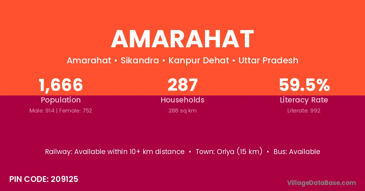
Amarahat village is located in the Sikandra Tehsil of the Kanpur Dehat district in Uttar Pradesh .
Block / Tehsil → Sikandra
District → Kanpur Dehat
State → Uttar Pradesh
According to Census 2011 information, the village code of Amarahat village is 209125.
Amarahat village has a total population of 1,666 people, of which 914 are males and 752 are females.
The literacy rate of Amarahat village is 59.54%. Male literacy stands at 66.52% and female literacy at 51.06%.
There are approximately 287 households in Amarahat village.
Oriya (15 km) is the nearest town to Amarahat village for major economic activities and is located approximately 15 km away.
The population of Amarahat village is distributed between literate and illiterate residents as follows:
| Particulars | Male | Female | Total |
|---|---|---|---|
| Literate | 608 | 384 | 992 |
| Illiterate | 306 | 368 | 674 |
| Total | 914 | 752 | 1,666 |
Source: Census 2011
| Village | District |
|---|---|
| Bachhoti Kachhar | Kanpur Dehat |
| Bharpura | Samastipur |
| Bharpura | Kanpur Dehat |
| Bharpura | Kanshiram Nagar |
| Bharpura | Mirzapur |
| Budhera Derapur | Kanpur Dehat |
| Gauhani Bangar | Kanpur Dehat |
| Gauhani Kachhar | Kanpur Dehat |
| Gauri Hasanpur | Kanpur Dehat |
| Hari Kishanpur | Azamgarh |
| Hari Kishanpur | Kanpur Dehat |
| Kariyapur Derapur | Kanpur Dehat |
| Khoaja Phool | Kanpur Dehat |
| Mahatauli | Kanpur Dehat |
| Sihura | Kanpur Dehat |
| Sihura | Unnao |
No reviews yet. Be the first to review this village!
Available within 10+ km distance
Available within 5 - 10 km distance
Available within 5 - 10 km distance