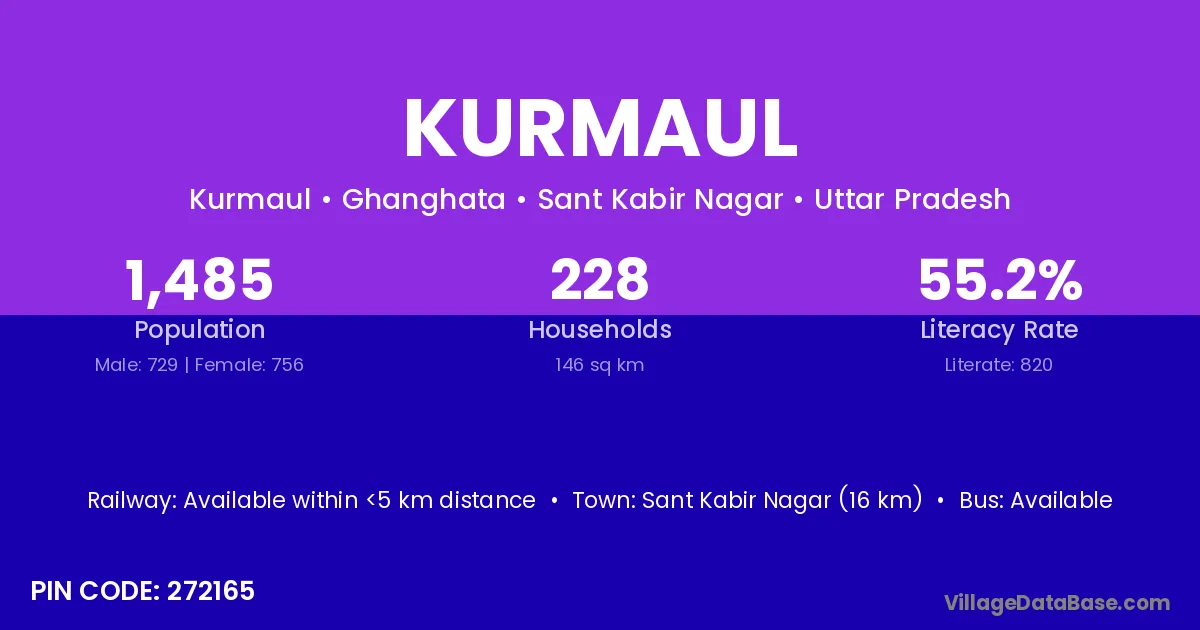
Kurmaul village is located in the Ghanghata Tehsil of the Sant Kabir Nagar district in Uttar Pradesh .
Block / Tehsil → Ghanghata
District → Sant Kabir Nagar
State → Uttar Pradesh
According to Census 2011 information, the village code of Kurmaul village is 272165.
Kurmaul village has a total population of 1,485 people, of which 729 are males and 756 are females.
The literacy rate of Kurmaul village is 55.22%. Male literacy stands at 64.47% and female literacy at 46.30%.
There are approximately 228 households in Kurmaul village.
Sant Kabir Nagar (16 km) is the nearest town to Kurmaul village for major economic activities and is located approximately 16 km away.
The population of Kurmaul village is distributed between literate and illiterate residents as follows:
| Particulars | Male | Female | Total |
|---|---|---|---|
| Literate | 470 | 350 | 820 |
| Illiterate | 259 | 406 | 665 |
| Total | 729 | 756 | 1,485 |
Source: Census 2011
| Village | District |
|---|---|
| Ban Kauli Kalan | Sant Kabir Nagar |
| Bhiughat | Sant Kabir Nagar |
| Chaksad | Gonda |
| Chaksad | Sant Kabir Nagar |
| Dhan Ghata | Sant Kabir Nagar |
| Lahurey Gaon | Sant Kabir Nagar |
| Mahthi | Samastipur |
| Mahthi | Sant Kabir Nagar |
| Nainahia Jot | Sant Kabir Nagar |
| Nainiha Naik | Sant Kabir Nagar |
| Naun Kala | Sant Kabir Nagar |
| Naunjot | Sant Kabir Nagar |
| Thakura Dandi | Sant Kabir Nagar |
No reviews yet. Be the first to review this village!
Available within <5 km distance
Available within <5 km distance
Available within <5 km distance