Joshimath: A Town and Tehsil in Chamoli district
District → Chamoli
State → Uttarakhand
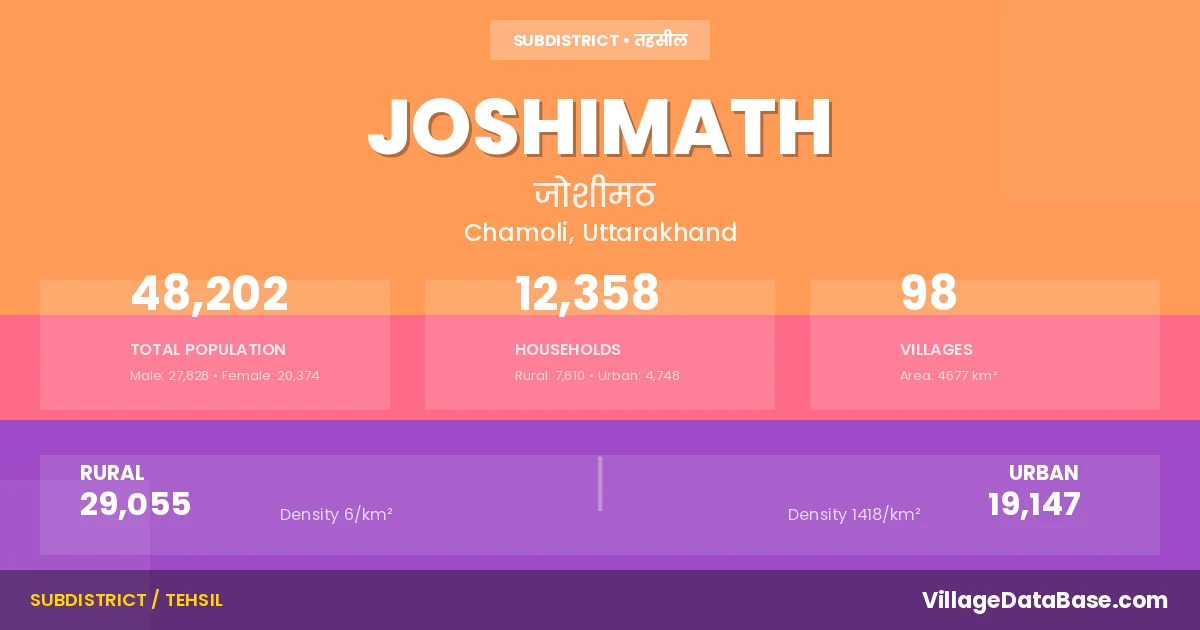
Joshimath is a town and Tehsil in the Chamoli district of the Uttarakhand. In India, a Tehsil is a subdivision of a district responsible for the administration and revenue collection of a specific area within the district. Tehsils play a crucial role in the local governance structure, contributing significantly to the development and administration of their communities.
According to the 2011 census The total area of Joshimath Tehsil is 4677 km², with a population of 48202 people. The population density is 10 inhabitants per square kilometre, and there are approximately 12358 houses in the sub district.
Joshimath Tehsil comprises about 98 villages. Below is a list of these villages along with information about their respective gram panchayats and the nearest town:
| # | Village Name | Gram Panchayat | Nearest Town |
|---|---|---|---|
| 1 | Aira | Merag | Joshimath (5 km) |
| 2 | Arurhi Paturi | Lam Bagar | Joshimath (25 km) |
| 3 | Auli Laga Joshimath | Joshimath (15 km) | |
| 4 | Auli Laga Salude | Joshimath (18 km) | |
| 5 | Badal Gaitha | Tapovan | Joshimath (15 km) |
| 6 | Bampa | Bampa | Joshimath (80 km) |
| 7 | Bara Gaon | Baragaon | Joshimath (10 km) |
| 8 | Bhalgaon | Bhalagaon | Joshimath (31 km) |
| 9 | Bhangyul | Bhangyul | Joshimath (18 km) |
| 10 | Bharkichak Urgam | Bharki | Joshimath (25 km) |
| 11 | Bheta Chak Urgam | Bhenta | Joshimath (20 km) |
| 12 | Bhyudar | Bhyundar | Joshimath (29 km) |
| 13 | Bilagar | Tapovan | Joshimath (15 km) |
| 14 | Chaien | Chain | Joshimath (13 km) |
| 15 | Chamoli | Joshimath (50 km) | |
| 16 | Chamtoli | Kundi Khola | Joshimath (13 km) |
| 17 | Darmi | Ganai | Joshimath (28 km) |
| 18 | Dhak | Dhak | Joshimath (12 km) |
| 19 | Dronagiri | Dronagiri | Joshimath (66 km) |
| 20 | Dumak | Dumak | Gopeshwar (32 km) |
| 21 | Dwing | Dwing Tapaun | Joshimath (23 km) |
| 22 | F 1 | Joshimath (31 km) | |
| 23 | Fagti | Tolma | Joshimath (34 km) |
| 24 | Farkiagaon | Farkiya | Gopeshwar (75 km) |
| 25 | Gahar | Bhangyul | Joshimath (19 km) |
| 26 | Gamsali | Gamsali | Joshimath (85 km) |
| 27 | Ganai | Ganai | Joshimath (22 km) |
| 28 | Garpak | Dronagiri | Joshimath (66 km) |
| 29 | Gaunkh Laga Sailang | Selang | Joshimath (3 km) |
| 30 | Gulabkoti | Gulab Koti | Joshimath (18 km) |
| 31 | Gurguti | Mehargaon | Joshimath (90 km) |
| 32 | Hailang | Helang | Joshimath (13 km) |
| 33 | Inara | Baragaon | Joshimath (10 km) |
| 34 | Jakhola | Jakhola | Joshimath (32 km) |
| 35 | Jalam | Jelam | Joshimath (65 km) |
| 36 | Jalgwar | Pakhi | Joshimath (25 km) |
| 37 | Joshimath | Joshimath (30 km) | |
| 38 | Jugaju Chak Lata | Reini | Joshimath (26 km) |
| 39 | Jumma | Jelam | Joshimath (55 km) |
| 40 | Juwagwar | Reini | Joshimath (26 km) |
| 41 | Kaga Laga Dronagiri | Kaga | Joshimath (62 km) |
| 42 | Kailashpur | Kailashpur | Joshimath (70 km) |
| 43 | Kalgoth | Kalgoth | Joshimath (50 km) |
| 44 | Karachhon | Karchhon | Joshimath (18 km) |
| 45 | Karchi | Regdi | Joshimath (15 km) |
| 46 | Khancha Malla | Merag | Joshimath (3 km) |
| 47 | Khancha Talla | Merag | Joshimath (3 km) |
| 48 | Khiron | Lam Bagar | Joshimath (33 km) |
| 49 | Kimana | Kimana | Joshimath (32 km) |
| 50 | Kosa | Kosha | Joshimath (50 km) |
| 51 | Kundikhola | Kundi Khola | Joshimath (12 km) |
| 52 | Kuraipani | Tolma | Joshimath (12 km) |
| 53 | Lamtoli | Dronagiri | Joshimath (65 km) |
| 54 | Langsi | Langasi | Joshimath (18 km) |
| 55 | Lanji | Pokhani | Joshimath (24 km) |
| 56 | Lata | Lata | Joshimath (30 km) |
| 57 | Longsagari | Tolma | Joshimath (35 km) |
| 58 | Lyari Thana | Lyari Theina | Joshimath (27 km) |
| 59 | Mahargaon | Mehargaon | Joshimath (70 km) |
| 60 | Malari | Malari | Joshimath (75 km) |
| 61 | Mana | Mana | Badrinath (3 km) |
| 62 | Marwadi Chak Pakhi | Pakhi | Joshimath (31 km) |
| 63 | Mirg | Merag | Joshimath (6 km) |
| 64 | Molta | Molta | Joshimath (33 km) |
| 65 | Morana Chak Subhai | Reini | Joshimath (23 km) |
| 66 | Niti | Neeti | Joshimath (80 km) |
| 67 | Noligwar | Ganai | Joshimath (28 km) |
| 68 | Pagnau | Pagno | Joshimath (25 km) |
| 69 | Pagrasu | Tolma | Joshimath (34 km) |
| 70 | Pail Chak Bhyudar | Bhyundar | Joshimath (26 km) |
| 71 | Paini | Paini | Joshimath (7 km) |
| 72 | Pakhi | Pakhi | Joshimath (30 km) |
| 73 | Palla | Jakhola | Joshimath (35 km) |
| 74 | Pandukaswar | Pandukeshar | Joshimath (23 km) |
| 75 | Pang Chak Lata | Reini | Joshimath (23 km) |
| 76 | Payya Chormi | Baragaon | Joshimath (10 km) |
| 77 | Pokhani Urf Pokhari | Pokhani | Joshimath (35 km) |
| 78 | Raigari | Regdi | Joshimath (15 km) |
| 79 | Raini Chak Lata | Reini | Joshimath (24 km) |
| 80 | Raini Chak Subhai | Rani Chak Subhai | Joshimath (24 km) |
| 81 | Rewal Chak Kurkuti | Farkiya | Joshimath (95 km) |
| 82 | Ringi | Ringi | Joshimath (18 km) |
| 83 | Sailang | Selang | Joshimath (5 km) |
| 84 | Salna Chak Urgam | Lyari Theina | Joshimath (23 km) |
| 85 | Salud Dugra | Salud Dungra | Joshimath (10 km) |
| 86 | Subhai | Subhai | Joshimath (31 km) |
| 87 | Sukhi | Bhalagaon | Joshimath (24 km) |
| 88 | Tangni Malli | Tangani Malli | Joshimath (31 km) |
| 89 | Tangni Talli | Tangani Talli | Gopeshwar (45 km) |
| 90 | Tapon | Dwing Tapaun | Joshimath (21 km) |
| 91 | Thaing | Theing | Joshimath (25 km) |
| 92 | Tirosi | Dwing Tapaun | Joshimath (33 km) |
| 93 | Toli Laga Chiae | Chain | Joshimath (20 km) |
| 94 | Tolma | Tolma | Joshimath (33 km) |
| 95 | Topovan | Tapovan | Joshimath (15 km) |
| 96 | Tugasi | Regdi | Joshimath (20 km) |
| 97 | Uchougaur | Kalgoth | Joshimath (40 km) |
| 98 | Urgam | Urgam | Joshimath (26 km) |
The population is distributed between urban and rural areas as follows:
| Particulars | Rural | Urban | Total |
|---|---|---|---|
| Total Population | 29055 | 19147 | 48202 |
| Male Population | 15786 | 12042 | 27828 |
| Female Population | 13269 | 7105 | 20374 | Population Density | 6 / km² | 1418 / km² | 10 / km² |
The distribution of households in the Joshimath is:
| Rural Households | Urban Households | Total Households |
|---|---|---|
| 7610 | 4748 | 12358 |
Q: What is Joshimath?
A: Joshimath is a town and in the Chamoli district of the Uttarakhand.
Q: What is the total area of Joshimath Tehsil?
A: The total area of Joshimath Tehsil is 4677 km².
Q: What is the population of Joshimath Tehsil according to the 2011 census?
A: According to the 2011 census, the population of Joshimath Tehsil is 48202.
Q: What is the population density of Joshimath Tehsil?
A: The population density of Joshimath Tehsil is 10 inhabitants per square kilometre.
Q: How many houses are there in Joshimath Tehsil?
A: There are approximately 12358 houses in Joshimath Tehsil.
Q: How many villages are there in Joshimath Tehsil?
A: There are about 98 villages in Joshimath Tehsil.
Q: Which is the largest village by population in Joshimath Tehsil?
A: The largest village by population in Joshimath Tehsil is Malari, with 1933 people.
Q: Which is the smallest village by population in Joshimath Tehsil?
A: The smallest village by population in Joshimath Tehsil is Badal Gaitha, with 0 people.
Q: Which is the largest village by area in Joshimath Tehsil?
A: The largest village by area in Joshimath Tehsil is Mana, with 88978 km².
Q: Which is the smallest village by area in Joshimath Tehsil?
A: The smallest village by area in Joshimath Tehsil is Chamoli, with 0 km².
Q: What is the male population of Joshimath Tehsil?
A: The male population of Joshimath Tehsil is 27828.
Q: What is the female population of Joshimath Tehsil?
A: The female population of Joshimath Tehsil is 20374.
Q: How many villages in Joshimath Tehsil have a population of less than 100?
A: There are 33 villages in Joshimath Tehsil with a population of less than 100.
Q: How many villages in Joshimath Tehsil have a population between 100 and 499?
A: There are 51 villages in Joshimath Tehsil with a population between 100 and 499.
Q: How many villages in Joshimath Tehsil have a population between 500 and 999?
A: There are 8 villages in Joshimath Tehsil with a population between 500 and 999.
Q: How many villages in Joshimath Tehsil have a population between 1000 and 1999?
A: There are 6 villages in Joshimath Tehsil with a population between 1000 and 1999.
| Total Population | Villages in Sub District Of Joshimath |
|---|---|
| Less than 100 | 33 |
| 100-499 | 51 |
| 500-999 | 8 |
| 1000-1999 | 6 |