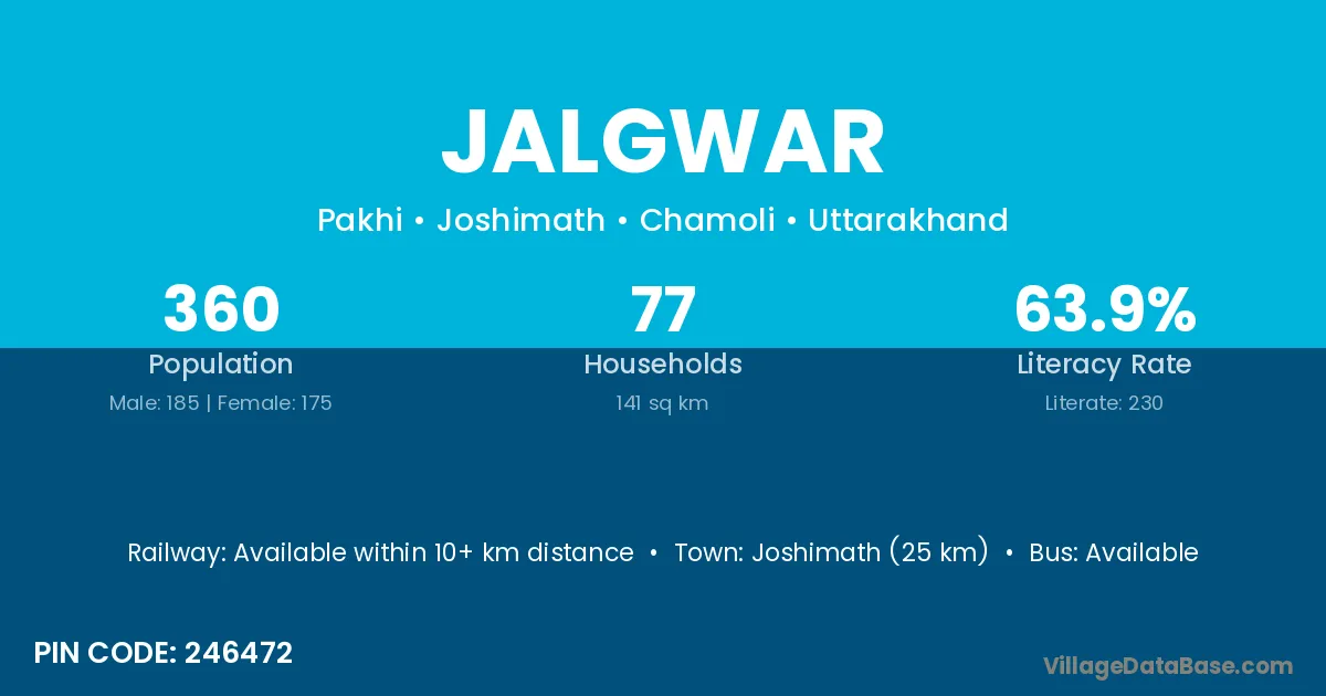
Jalgwar village is located in the Joshimath Tehsil of the Chamoli district in Uttarakhand .
Block / Tehsil → Joshimath
District → Chamoli
State → Uttarakhand
According to Census 2011 information, the village code of Jalgwar village is 246472.
Jalgwar village has a total population of 360 people, of which 185 are males and 175 are females.
The literacy rate of Jalgwar village is 63.89%. Male literacy stands at 75.14% and female literacy at 52.00%.
There are approximately 77 households in Jalgwar village.
Joshimath (25 km) is the nearest town to Jalgwar village for major economic activities and is located approximately 25 km away.
The population of Jalgwar village is distributed between literate and illiterate residents as follows:
| Particulars | Male | Female | Total |
|---|---|---|---|
| Literate | 139 | 91 | 230 |
| Illiterate | 46 | 84 | 130 |
| Total | 185 | 175 | 360 |
Source: Census 2011
| Village | District |
|---|---|
| Darmi | Aurangabad |
| Darmi | Garhwa |
| Darmi | Chamoli |
| Gulabkoti | Chamoli |
| Langsi | Chamoli |
| Marwadi Chak Pakhi | Chamoli |
| Molta | Chamoli |
| Noligwar | Chamoli |
| Pagnau | Chamoli |
| Pakhi | Lower Subansiri |
| Pakhi | Darbhanga |
| Pakhi | Hamirpur |
| Pakhi | Chamoli |
| Tangni Malli | Chamoli |
| Tangni Talli | Chamoli |
| Tapon | Chamoli |
No reviews yet. Be the first to review this village!
Available within 10+ km distance
Available within <5 km distance
Available within <5 km distance