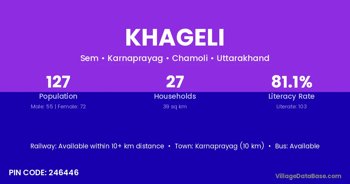
Khageli village is located in the Karnaprayag Tehsil of the Chamoli district in Uttarakhand .
Block / Tehsil → Karnaprayag
District → Chamoli
State → Uttarakhand
According to Census 2011 information, the village code of Khageli village is 246446.
Khageli village has a total population of 127 people, of which 55 are males and 72 are females.
The literacy rate of Khageli village is 81.10%. Male literacy stands at 89.09% and female literacy at 75.00%.
There are approximately 27 households in Khageli village.
Karnaprayag (10 km) is the nearest town to Khageli village for major economic activities and is located approximately 10 km away.
The population of Khageli village is distributed between literate and illiterate residents as follows:
| Particulars | Male | Female | Total |
|---|---|---|---|
| Literate | 49 | 54 | 103 |
| Illiterate | 6 | 18 | 24 |
| Total | 55 | 72 | 127 |
Source: Census 2011
| Village | District |
|---|---|
| Bhatoli Lagga Top | Chamoli |
| Karakot | Chamoli |
| Karakot | Tehri Garhwal |
| Karakot | Tehri Garhwal |
| Khageta Laga Top | Chamoli |
| Khandura | Chamoli |
| Koni Laga Khageli | Chamoli |
| Kwagar Lagga Top | Chamoli |
| Laloti | Chamoli |
| Ratura | Chamoli |
| Sem | Jalaun |
| Sem | Chamoli |
| Sem | Chamoli |
| Sem | Rudraprayag |
| Sem | Tehri Garhwal |
| Sem | Tehri Garhwal |
| Swarka | Chamoli |
| Top | Patna |
| Top | Hamirpur |
| Top | Kolhapur |
| Top | Chamoli |
No reviews yet. Be the first to review this village!
Available within 10+ km distance
Available within <5 km distance
Available within <5 km distance