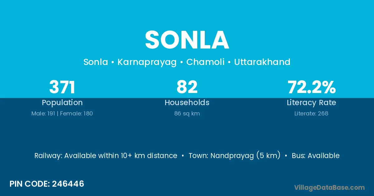
Sonla village is located in the Karnaprayag Tehsil of the Chamoli district in Uttarakhand .
Block / Tehsil → Karnaprayag
District → Chamoli
State → Uttarakhand
According to Census 2011 information, the village code of Sonla village is 246446.
Sonla village has a total population of 371 people, of which 191 are males and 180 are females.
The literacy rate of Sonla village is 72.24%. Male literacy stands at 83.77% and female literacy at 60.00%.
There are approximately 82 households in Sonla village.
Nandprayag (5 km) is the nearest town to Sonla village for major economic activities and is located approximately 5 km away.
The population of Sonla village is distributed between literate and illiterate residents as follows:
| Particulars | Male | Female | Total |
|---|---|---|---|
| Literate | 160 | 108 | 268 |
| Illiterate | 31 | 72 | 103 |
| Total | 191 | 180 | 371 |
Source: Census 2011
| Village | District |
|---|---|
| Bantoli | Gumla |
| Bantoli | Bageshwar |
| Bantoli | Chamoli |
| Bantoli | Champawat |
| Bantoli | Pithoragarh |
| Biroli Laga Ghinta | Chamoli |
| Chamali | Chamoli |
| Chamali | Garhwal |
| Chamali | Garhwal |
| Chamali | Garhwal |
| Dugalwali | Chamoli |
| Hadkoti | Chamoli |
| Mangroli | Hamirpur |
| Mangroli | Datia |
| Mangroli | Gautam Buddha Nagar |
| Mangroli | Chamoli |
| Nauli Talli | Chamoli |
| Rambori | Chamoli |
| Sem | Jalaun |
| Sem | Chamoli |
| Sem | Chamoli |
| Sem | Rudraprayag |
| Sem | Tehri Garhwal |
| Sem | Tehri Garhwal |
| Tefna | Chamoli |
| Umrakot Urf Baidanu | Chamoli |
No reviews yet. Be the first to review this village!
Available within 10+ km distance
Available within village
Available within village