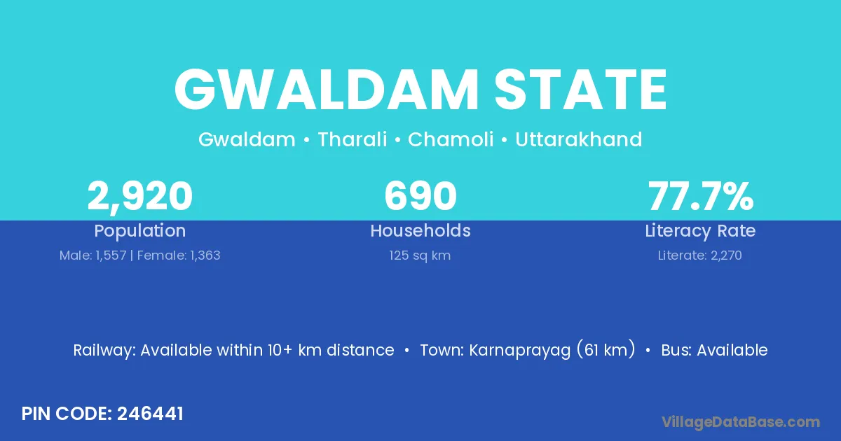
Gwaldam State village is located in the Tharali Tehsil of the Chamoli district in Uttarakhand .
Block / Tehsil → Tharali
District → Chamoli
State → Uttarakhand
According to Census 2011 information, the village code of Gwaldam State village is 246441.
Gwaldam State village has a total population of 2,920 people, of which 1,557 are males and 1,363 are females.
The literacy rate of Gwaldam State village is 77.74%. Male literacy stands at 85.10% and female literacy at 69.33%.
There are approximately 690 households in Gwaldam State village.
Karnaprayag (61 km) is the nearest town to Gwaldam State village for major economic activities and is located approximately 61 km away.
The population of Gwaldam State village is distributed between literate and illiterate residents as follows:
| Particulars | Male | Female | Total |
|---|---|---|---|
| Literate | 1,325 | 945 | 2,270 |
| Illiterate | 232 | 418 | 650 |
| Total | 1,557 | 1,363 | 2,920 |
Source: Census 2011
| Village | District |
|---|---|
| Baisara | Bara Banki |
| Baisara | Chamoli |
| Baman Bera | Chamoli |
| Beradhar | Udaipur |
| Beradhar | Chamoli |
| Bhaduwa Simar Laga Asangara | Chamoli |
| Chidanga Khalsa | Chamoli |
| Chidanga State | Chamoli |
| Jola | Mandi |
| Jola | Sirmaur |
| Jola | Godda |
| Jola | Bid |
| Jola | Sawai Madhopur |
| Jola | Tonk |
| Jola | Chamoli |
| Kandai | Anjaw |
| Kandai | Durg |
| Kandai | Durg |
| Kandai | Durg |
| Kandai | Balaghat |
| Kandai | Guna |
| Kandai | Madurai |
| Kandai | Chamoli |
| Kandai | Chamoli |
| Kandai | Chamoli |
| Kandai | Chamoli |
| Kandai | Garhwal |
| Kandai | Garhwal |
| Kandai | Garhwal |
| Kandai | Garhwal |
| Kandai | Garhwal |
| Karbali Chak Beradhar | Chamoli |
| Loda | Karauli |
| Loda | Udaipur |
| Loda | Chamoli |
| Trikot | Chamoli |
| Trikot | Chamoli |
| Trikot | Tehri Garhwal |
No reviews yet. Be the first to review this village!
Available within 10+ km distance
Available within village
Available within village