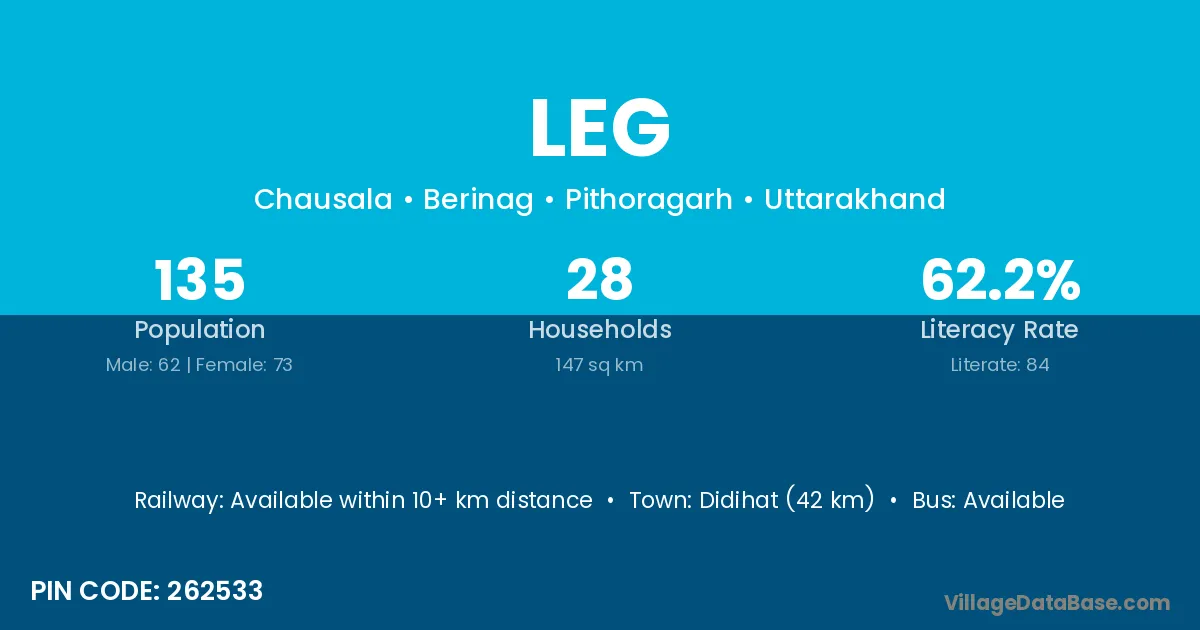
Leg village is located in the Berinag Tehsil of the Pithoragarh district in Uttarakhand .
Block / Tehsil → Berinag
District → Pithoragarh
State → Uttarakhand
According to Census 2011 information, the village code of Leg village is 262533.
Leg village has a total population of 135 people, of which 62 are males and 73 are females.
The literacy rate of Leg village is 62.22%. Male literacy stands at 82.26% and female literacy at 45.21%.
There are approximately 28 households in Leg village.
Didihat (42 km) is the nearest town to Leg village for major economic activities and is located approximately 42 km away.
The population of Leg village is distributed between literate and illiterate residents as follows:
| Particulars | Male | Female | Total |
|---|---|---|---|
| Literate | 51 | 33 | 84 |
| Illiterate | 11 | 40 | 51 |
| Total | 62 | 73 | 135 |
Source: Census 2011
| Village | District |
|---|---|
| Balyaoo | Pithoragarh |
| Bokal Katiya | Pithoragarh |
| Chausala | Amravati |
| Chausala | Amravati |
| Chausala | Bid |
| Chausala | Washim |
| Chausala | Pithoragarh |
| Dasoli | Bulandshahr |
| Dasoli | Pithoragarh |
| Dasoli | Tehri Garhwal |
| Daunu | Pithoragarh |
| Gwir Lagga Chausala | Pithoragarh |
| Kotgari | Pithoragarh |
| Kotgari | Uttarkashi |
| Masuriya | Korba |
| Masuriya | Deoghar |
| Masuriya | Hazaribagh |
| Masuriya | Dewas |
| Masuriya | Jhabua |
| Masuriya | Pithoragarh |
| Payra | Damoh |
| Payra | Bundi |
| Payra | Jhalawar |
| Payra | Pratapgarh |
| Payra | Udaipur |
| Payra | Pithoragarh |
| Sigalti | Pithoragarh |
| Tusrera | Pithoragarh |
No reviews yet. Be the first to review this village!
Available within 10+ km distance
Available within <5 km distance
Available within <5 km distance