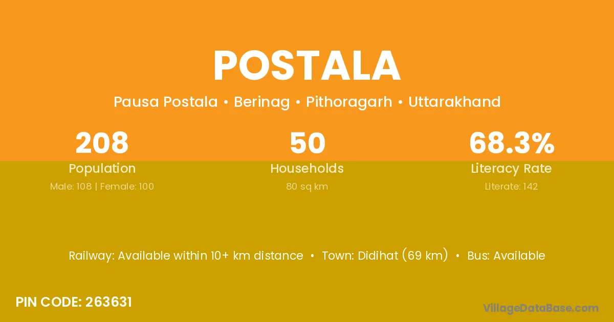
Postala village is located in the Berinag Tehsil of the Pithoragarh district in Uttarakhand .
Block / Tehsil → Berinag
District → Pithoragarh
State → Uttarakhand
According to Census 2011 information, the village code of Postala village is 263631.
Postala village has a total population of 208 people, of which 108 are males and 100 are females.
The literacy rate of Postala village is 68.27%. Male literacy stands at 75.00% and female literacy at 61.00%.
There are approximately 50 households in Postala village.
Didihat (69 km) is the nearest town to Postala village for major economic activities and is located approximately 69 km away.
The population of Postala village is distributed between literate and illiterate residents as follows:
| Particulars | Male | Female | Total |
|---|---|---|---|
| Literate | 81 | 61 | 142 |
| Illiterate | 27 | 39 | 66 |
| Total | 108 | 100 | 208 |
Source: Census 2011
| Village | District |
|---|---|
| Bhati Gaon | Garhwal |
| Bhati Gaon | Pithoragarh |
| Bora Khet | Pithoragarh |
| Chhana | Bageshwar |
| Chhana | Pithoragarh |
| Jhalada | Pithoragarh |
| Khitauli | Katni |
| Khitauli | Firozabad |
| Khitauli | Kanshiram Nagar |
| Khitauli | Mahamaya Nagar |
| Khitauli | Pithoragarh |
| Pousa | Pithoragarh |
| Pungar Kholi | Pithoragarh |
| Suklyari | Pithoragarh |
| Tamoli Gwir | Pithoragarh |
| Thanga | Sirmaur |
| Thanga | Bishnupur |
| Thanga | Bageshwar |
| Thanga | Pithoragarh |
| Ukhera | Pithoragarh |
No reviews yet. Be the first to review this village!
Available within 10+ km distance
Available within 5 - 10 km distance
Available within 5 - 10 km distance