Darma village is located in the Munsiari Tehsil of the Pithoragarh district in Uttarakhand .
Block / Tehsil → Munsiari
District → Pithoragarh
State → Uttarakhand
According to Census 2011 information, the village code of Darma village is 262555.
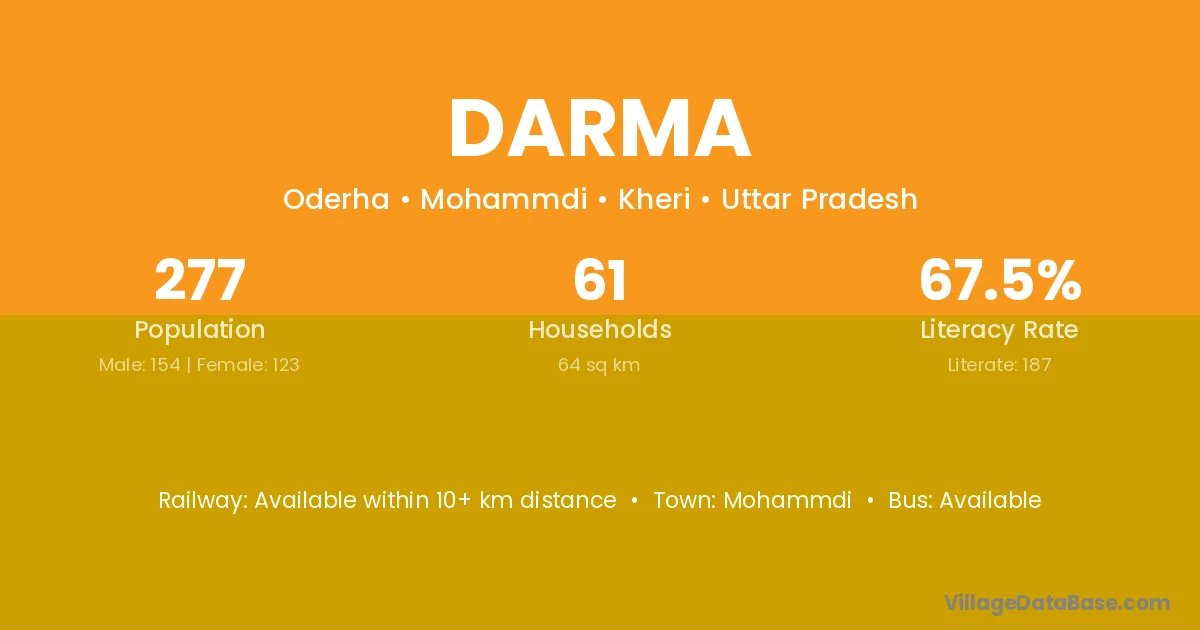
Darma village has a total population of 276 people, of which 123 are males and 153 are females.
The literacy rate of Darma village is 67.75%. Male literacy stands at 82.93% and female literacy at 55.56%.
There are approximately 64 households in Darma village.
Didihat (55 km) is the nearest town to Darma village for major economic activities and is located approximately 55 km away.
The population of Darma village is distributed between literate and illiterate residents as follows:
| Particulars | Male | Female | Total |
|---|---|---|---|
| Literate | 102 | 85 | 187 |
| Illiterate | 21 | 68 | 89 |
| Total | 123 | 153 | 276 |
Source: Census 2011
| Village | District |
|---|---|
| Alam | Pithoragarh |
| Dhauliua Dunga | Pithoragarh |
| Dhuratoli | Pithoragarh |
| Khartoli | Morigaon |
| Khartoli | Pithoragarh |
| Lodi | Nabarangapur |
| Lodi | Pithoragarh |
| Mani Dhami | Pithoragarh |
| Mawani Dawani | Pithoragarh |
| Seeling | Pithoragarh |
| Sera | Kurung Kumey |
| Sera | Upper Subansiri |
| Sera | Banas Kantha |
| Sera | Solan |
| Sera | Ratlam |
| Sera | Ratlam |
| Sera | Udaipur |
| Sera | Chamoli |
| Sera | Chamoli |
| Sera | Chamoli |
| Sera | Pithoragarh |
| Sera | Pithoragarh |
| Sera | Pithoragarh |
| Sera | Rudraprayag |
| Sera | Tehri Garhwal |
| Sera | Tehri Garhwal |
| Sirtola | Pithoragarh |
| Sirtola | Pithoragarh |
| Uchhaiti | Pithoragarh |
No reviews yet. Be the first to review this village!
Available within 10+ km distance
Available within 10+ km distance
Available within 10+ km distance