Gorubathan: A Town and Subdivision in Darjiling district
District → Darjiling
State → West Bengal
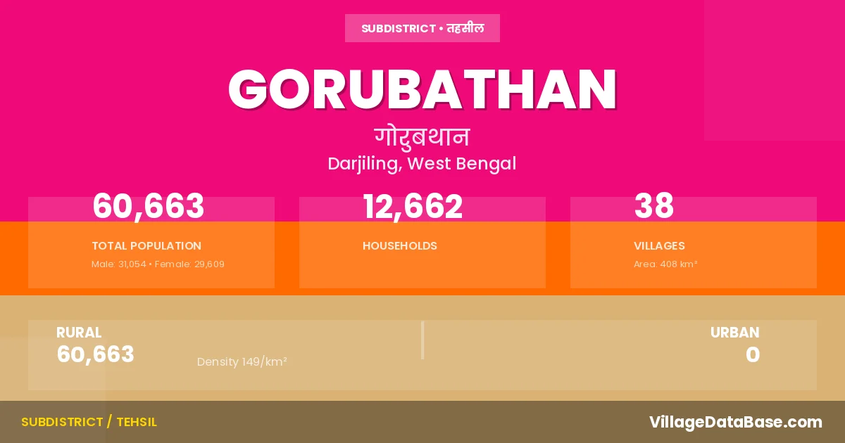
Gorubathan is a town and Subdivision in the Darjiling district of the West Bengal. In India, a Subdivision is a subdivision of a district responsible for the administration and revenue collection of a specific area within the district. Subdivisions play a crucial role in the local governance structure, contributing significantly to the development and administration of their communities.
According to the 2011 census The total area of Gorubathan Subdivision is 408 km², with a population of 60663 people. The population density is 149 inhabitants per square kilometre, and there are approximately 12662 houses in the sub district.
Gorubathan Subdivision comprises about 38 villages. Below is a list of these villages along with information about their respective gram panchayats and the nearest town:
| # | Village Name | Gram Panchayat | Nearest Town |
|---|---|---|---|
| 1 | Ambeok Forest | Garubathan Ii | Gorubathan |
| 2 | Ambeok Tea Garden | Dalim | Mal Bazar (10 km) |
| 3 | Chichu Forest | Rongo | Gorubathan |
| 4 | Dalingkot Forest | Dalim | Mal Bazar (10 km) |
| 5 | Dalingma Khasmahal | Dalim | Mal Bazar (10 km) |
| 6 | Darjiling Hilldoars Tea Garden | Aahaley | Mal Bazar (10 km) |
| 7 | Eastnar Forest | Garubathan Ii | Gorubathan |
| 8 | Gorubathan Khasmahal | Aahaley | Mal Bazar (10 km) |
| 9 | Kumai Forest | Kumai | Mal Bazar (40 km) |
| 10 | Kumai Khasmahal | Kumai | Mal Bazar (10 km) |
| 11 | Kumai Tea Garden | Kumai | Mal Bazar (10 km) |
| 12 | Lehti Forest | Pokhreybong | Mal Bazar (10 km) |
| 13 | Lower Fagu Tea Garden | Aahaley | Mal Bazar (10 km) |
| 14 | Mal Forest | Garubathan I | Mal Bazar (18 km) |
| 15 | Mal Khasmahal | Garubathan I | Mal Bazar (10 km) |
| 16 | Manabari Khasmahal | Pokhreybong | Gorubathan |
| 17 | Mo Forest | Rongo | Gorubathan |
| 18 | Nim Khasmahal | Nim | Mal Bazar (10 km) |
| 19 | Noam Forest | Pokhreybong | Oddlabari (10 km) |
| 20 | Pagrang Bong Khasmahal | Pokhreybong | Oddlabari (10 km) |
| 21 | Pankasari Forest | Garubathan Ii | Mal Bazar (10 km) |
| 22 | Pankhasari Khasmahal | Garubathan Ii | Mal Bazar (10 km) |
| 23 | Paren Forest | Rongo | Mal Bazar (40 km) |
| 24 | Pashiting Khasmahal | Nim | Mal Bazar (10 km) |
| 25 | Paten Godak Khasmahal | Patengodak | Kalimpong (11 km) |
| 26 | Pogu Forest | Pokhreybong | Malbazar (22 km) |
| 27 | Rango Forest | Rongo | Mal Bazar (40 km) |
| 28 | Rechila Chak Khasmahal | Rongo | Gorubathan |
| 29 | Rechila Forest | Rongo | Gorubathan |
| 30 | Ruka Forest | Rongo | Gorubathan |
| 31 | Sakam Forest | Aahaley | Gorubathan |
| 32 | Samabiyong Tea Garden | Nim | Mal Bazar (10 km) |
| 33 | Samsing Khasmahal | Samsing | Mal Bajar (10 km) |
| 34 | Thousum Forest | Rongo | Gorubathan |
| 35 | Today Tangta Khasmahal | Todeytangta | Mal Bazar (10 km) |
| 36 | Turibari Khasmahal | Pokhreybong | Gorubathan |
| 37 | Upper Fagu Tea Garden | Nim | Mal Bazar (10 km) |
| 38 | Westnar Forest | Kumai | Gorubathan |
The population is distributed between urban and rural areas as follows:
| Particulars | Rural | Urban | Total |
|---|---|---|---|
| Total Population | 60663 | 0 | 60663 |
| Male Population | 31054 | 0 | 31054 |
| Female Population | 29609 | 0 | 29609 | Population Density | 149 / km² | 149 / km² |
The distribution of households in the Gorubathan is:
| Rural Households | Urban Households | Total Households |
|---|---|---|
| 12662 | 0 | 12662 |
Q: What is Gorubathan?
A: Gorubathan is a town and in the Darjiling district of the West Bengal.
Q: What is the total area of Gorubathan Subdivision?
A: The total area of Gorubathan Subdivision is 408 km².
Q: What is the population of Gorubathan Subdivision according to the 2011 census?
A: According to the 2011 census, the population of Gorubathan Subdivision is 60663.
Q: What is the population density of Gorubathan Subdivision?
A: The population density of Gorubathan Subdivision is 149 inhabitants per square kilometre.
Q: How many houses are there in Gorubathan Subdivision?
A: There are approximately 12662 houses in Gorubathan Subdivision.
Q: How many villages are there in Gorubathan Subdivision?
A: There are about 38 villages in Gorubathan Subdivision.
Q: Which is the largest village by population in Gorubathan Subdivision?
A: The largest village by population in Gorubathan Subdivision is Rango Forest, with 9131 people.
Q: Which is the smallest village by population in Gorubathan Subdivision?
A: The smallest village by population in Gorubathan Subdivision is Ambeok Forest, with 0 people.
Q: Which is the largest village by area in Gorubathan Subdivision?
A: The largest village by area in Gorubathan Subdivision is Eastnar Forest, with 3163 km².
Q: Which is the smallest village by area in Gorubathan Subdivision?
A: The smallest village by area in Gorubathan Subdivision is Manabari Khasmahal, with 3 km².
Q: What is the population distribution between urban and rural areas in Gorubathan Subdivision?
A: The population distribution in Gorubathan Subdivision is entirely rural, with a total rural population of 60663.
Q: What is the male population of Gorubathan Subdivision?
A: The male population of Gorubathan Subdivision is 31054.
Q: What is the female population of Gorubathan Subdivision?
A: The female population of Gorubathan Subdivision is 29609.
Q: How is the household distribution in Gorubathan Subdivision?
A: The household distribution in Gorubathan Subdivision is entirely rural, with a total of 12662 households.
Q: How many villages in Gorubathan Subdivision have a population of less than 100?
A: There are 11 villages in Gorubathan Subdivision with a population of less than 100.
Q: How many villages in Gorubathan Subdivision have a population between 100 and 499?
A: There are 6 villages in Gorubathan Subdivision with a population between 100 and 499.
Q: How many villages in Gorubathan Subdivision have a population between 500 and 999?
A: There are 2 villages in Gorubathan Subdivision with a population between 500 and 999.
Q: How many villages in Gorubathan Subdivision have a population between 1000 and 1999?
A: There are 9 villages in Gorubathan Subdivision with a population between 1000 and 1999.
Q: How many villages in Gorubathan Subdivision have a population between 2000 and 2999?
A: There is 2 village in Gorubathan Subdivision with a population between 2000 and 2999.
Q: How many villages in Gorubathan Subdivision have a population between 3000 and 3999?
A: There is 4 village in Gorubathan Subdivision with a population between 3000 and 3999.
Q: How many villages in Gorubathan Subdivision have a population of 5000 and above?
A: There is 4 village in Gorubathan Subdivision with a population of 5000 and above.
| Total Population | Villages in Sub District Of Gorubathan |
|---|---|
| Less than 100 | 11 |
| 100-499 | 6 |
| 500-999 | 2 |
| 1000-1999 | 9 |
| 2000-2999 | 2 |
| 3000-3999 | 4 |
| 5000 And Above | 4 |