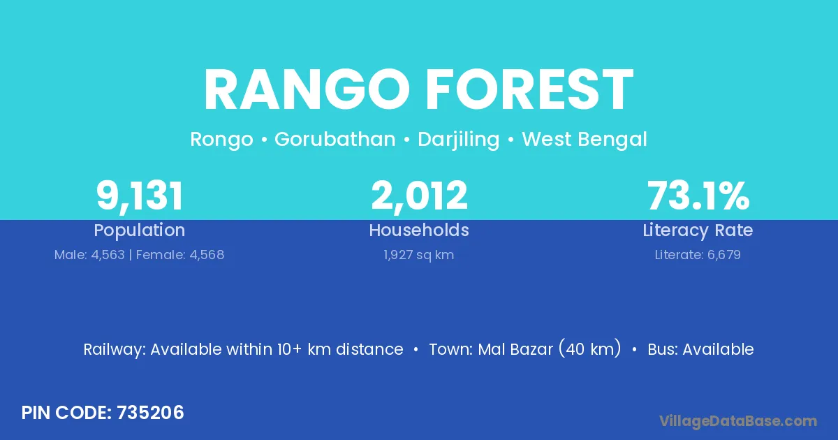
Rango Forest village is located in the Gorubathan Subdivision of the Darjiling district in West Bengal .
Block / Subdivision → Gorubathan
District → Darjiling
State → West Bengal
According to Census 2011 information, the village code of Rango Forest village is 735206.
Rango Forest village has a total population of 9,131 people, of which 4,563 are males and 4,568 are females.
The literacy rate of Rango Forest village is 73.15%. Male literacy stands at 79.51% and female literacy at 66.79%.
There are approximately 2,012 households in Rango Forest village.
Mal Bazar (40 km) is the nearest town to Rango Forest village for major economic activities and is located approximately 40 km away.
The population of Rango Forest village is distributed between literate and illiterate residents as follows:
| Particulars | Male | Female | Total |
|---|---|---|---|
| Literate | 3,628 | 3,051 | 6,679 |
| Illiterate | 935 | 1,517 | 2,452 |
| Total | 4,563 | 4,568 | 9,131 |
Source: Census 2011
| Village | District |
|---|---|
| Chichu Forest | Darjiling |
| Eastnar Forest | Darjiling |
| Kumai Khasmahal | Darjiling |
| Kumai Tea Garden | Darjiling |
| Mo Forest | Darjiling |
| Paren Forest | Darjiling |
| Paten Godak Khasmahal | Darjiling |
| Ruka Forest | Darjiling |
| Samsing Khasmahal | Darjiling |
| Thousum Forest | Darjiling |
| Today Tangta Khasmahal | Darjiling |
No reviews yet. Be the first to review this village!
Available within 10+ km distance
Available within 10+ km distance
Available within <5 km distance