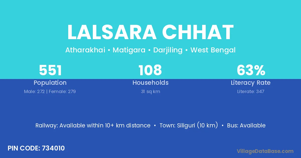
Lalsara Chhat village is located in the Matigara Subdivision of the Darjiling district in West Bengal .
Block / Subdivision → Matigara
District → Darjiling
State → West Bengal
According to Census 2011 information, the village code of Lalsara Chhat village is 734010.
Lalsara Chhat village has a total population of 551 people, of which 272 are males and 279 are females.
The literacy rate of Lalsara Chhat village is 62.98%. Male literacy stands at 70.59% and female literacy at 55.56%.
There are approximately 108 households in Lalsara Chhat village.
Siliguri (10 km) is the nearest town to Lalsara Chhat village for major economic activities and is located approximately 10 km away.
The population of Lalsara Chhat village is distributed between literate and illiterate residents as follows:
| Particulars | Male | Female | Total |
|---|---|---|---|
| Literate | 192 | 155 | 347 |
| Illiterate | 80 | 124 | 204 |
| Total | 272 | 279 | 551 |
Source: Census 2011
| Village | District |
|---|---|
| Bataliguri | Darjiling |
| Dumriguri Chhat | Darjiling |
| Gouri | Saraikela Kharsawan |
| Gouri | Gajapati |
| Gouri | Adilabad |
| Gouri | Adilabad |
| Gouri | Ballia |
| Gouri | Ballia |
| Gouri | Deoria |
| Gouri | Fatehpur |
| Gouri | Darjiling |
| Jugibhita | Darjiling |
| Jugibhita | Jalpaiguri |
| Kawakhari | Darjiling |
| Lachka | Darjiling |
| Nengtichhara | Darjiling |
| Nimai | Darjiling |
| Panchakulguri | Darjiling |
| Pataner Chhat | Darjiling |
| Rangia | Panna |
| Rangia | Darjiling |
No reviews yet. Be the first to review this village!
Available within 10+ km distance
Available within 5 - 10 km distance
Available within 5 - 10 km distance