Amta I: A Town and Subdivision in Haora district
District → Haora
State → West Bengal
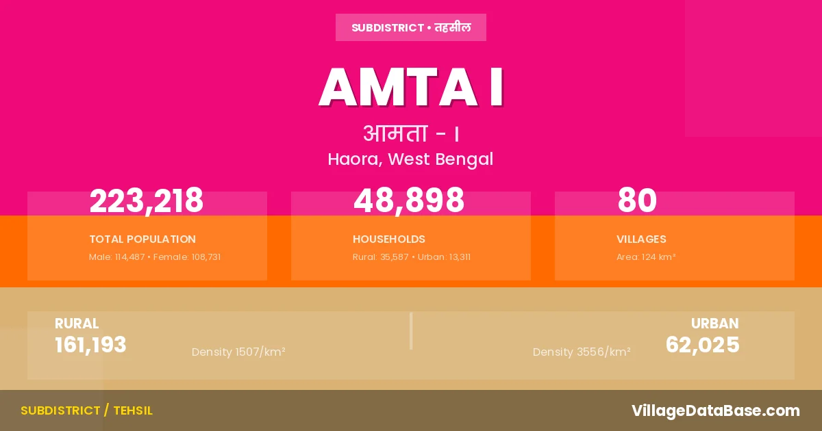
Amta I is a town and Subdivision in the Haora district of the West Bengal. In India, a Subdivision is a subdivision of a district responsible for the administration and revenue collection of a specific area within the district. Subdivisions play a crucial role in the local governance structure, contributing significantly to the development and administration of their communities.
According to the 2011 census The total area of Amta I Subdivision is 124 km², with a population of 223218 people. The population density is 1,795 inhabitants per square kilometre, and there are approximately 48898 houses in the sub district.
Amta I Subdivision comprises about 80 villages. Below is a list of these villages along with information about their respective gram panchayats and the nearest town:
| # | Village Name | Gram Panchayat | Nearest Town |
|---|---|---|---|
| 1 | Amta | Amta | Amta I |
| 2 | Anule | Anulia | Uluberia (25 km) |
| 3 | Balichak | Balichak | Uluberia (35 km) |
| 4 | Baneshwarpur | Anulia | Uluberia (25 km) |
| 5 | Banuchak | Balichak | Uluberia (36 km) |
| 6 | Bara Mahara | Khosalpur | Amta (5 km) |
| 7 | Barue | Kanpur | Howrah (40 km) |
| 8 | Basantapur | Basantapur | Amta I |
| 9 | Begua | Balichak | Uluberia (25 km) |
| 10 | Bhandar Gachha | Bhandargachha | Amta I |
| 11 | Bhetkepara | Basantapur | Howrah (40 km) |
| 12 | Bhojan | Balichak | Uluberia (24 km) |
| 13 | Chakpota | Raspur | Howrah (30 km) |
| 14 | Chaksadar | Khardah | Amta I |
| 15 | Chaltakhali | Khosalpur | Amta (9 km) |
| 16 | Chalunia | Anulia | Uluberia (30 km) |
| 17 | Chandrapur | Chandrapur | Amta I |
| 18 | Chatra | Chandrapur | Uluberia (13 km) |
| 19 | Chhota Mahara | Sirajbati | Amta (2 km) |
| 20 | Dadpur | Bhandargachha | Uluberia (14 km) |
| 21 | Dakshin Harishpur | Chandrapur | Uluberia (12 km) |
| 22 | Dakshin Ramchandrapur | Heerapur | Uluberia (14 km) |
| 23 | Damodar Nadirchar | Amta | Uluberia (17 km) |
| 24 | Darapur | Anulia | Uluberia (30 km) |
| 25 | Debandi | Anulia | Uluberia. (25 km) |
| 26 | Deora | Udang Ii | Amta I |
| 27 | Dhurkhali | Balichak | Uluberia (31 km) |
| 28 | Fatepur | Udang I | Uluberia (24 km) |
| 29 | Ghoradaha | Kanpur | Howrah (40 km) |
| 30 | Ghoshpur | Amta | Uluberia (15 km) |
| 31 | Ghuteghari | Kanpur | Howrah (45 km) |
| 32 | Gobinda Chak | Khardah | Uluberia (15 km) |
| 33 | Guzarpur | Amta | Uluberia (16 km) |
| 34 | Habla | Basantapur | Howrah (45 km) |
| 35 | Hafez Chak | Khardah | Uluberia (8 km) |
| 36 | Janjali Chak | Khardah | Uluberia (12 km) |
| 37 | Jotkalyan | Sirajbati | Amta (1 km) |
| 38 | Jotsadar | Khosalpur | Amta I |
| 39 | Kadua | Kandua | Uluberia (25 km) |
| 40 | Kalikata | Raspur | Uluberia (32 km) |
| 41 | Kanpur | Kanpur | Amta I |
| 42 | Kashtasangara | Khosalpur | Amta (5 km) |
| 43 | Kasra | Khosalpur | Amta (5 km) |
| 44 | Kazir Chak | Khardah | Uluberia (15 km) |
| 45 | Khaira | Hatgachha I | Uluberia (30 km) |
| 46 | Khardaha | Khardah | Uluberia (20 km) |
| 47 | Khasnan | Udang I | Uluberia (24 km) |
| 48 | Khosalpur | Khosalpur | Amta (5 km) |
| 49 | Kotalpara | Raspur | Howrah (32 km) |
| 50 | Kumar Chak | Khardah | Uluberia (15 km) |
| 51 | Kumaria | Raspur | Uluberia (32 km) |
| 52 | Kurit | Khosalpur | Amta (5 km) |
| 53 | Madaria | Sirajbati | Uluberia (17 km) |
| 54 | Madhyakul | Khardah | Uluberia. (18 km) |
| 55 | Mahishgoha | Chandrapur | Uluberia (15 km) |
| 56 | Mallagram | Sirajbati | Amta (1 km) |
| 57 | Manikara | Kanpur | Howrah (40 km) |
| 58 | Mato | Kanpur | Howrah (42 km) |
| 59 | Mollar Chak | Khardah | Uluberia (15 km) |
| 60 | Panpur | Bhandargachha | Uluberia (14 km) |
| 61 | Pearapur | Basantapur | Howrah (44 km) |
| 62 | Purash | Kanpur | Howrah (40 km) |
| 63 | Purba Bajepratap | Balichak | Uluberia (34 km) |
| 64 | Purba Gazipur | Dhandali | Uluberia (22 km) |
| 65 | Putkhali | Raspur | Uluberia (32 km) |
| 66 | Ramchandrapur Dwityakhanda | Sankrail | Uluberia (25 km) |
| 67 | Ranapara | Udang Ii | Uluberia (30 km) |
| 68 | Raspur | Raspur | Howrah (47 km) |
| 69 | Ratanpota | Khosalpur | Amta (10 km) |
| 70 | Sahapur | Kanpur | Amta I |
| 71 | Saibana | Balichak | Uluberia (27 km) |
| 72 | Sameshwar | Raspur | Uluberia (32 km) |
| 73 | Sarpai | Balichak | Uluberia (25 km) |
| 74 | Sarpota | Anulia | Uluberia (25 km) |
| 75 | Serajbati | Sirajbati | Uluberia (17 km) |
| 76 | Serpur | Bhandargachha | Uluberia (12 km) |
| 77 | Sonamui | Khardah | Uluberia (22 km) |
| 78 | Tentuliapara | Khardah | Uluberia (22 km) |
| 79 | Udang | Udang I | Amta I |
| 80 | Uttar Ramchandrapur | Maheshpur | Uluberia. (25 km) |
The population is distributed between urban and rural areas as follows:
| Particulars | Rural | Urban | Total |
|---|---|---|---|
| Total Population | 161193 | 62025 | 223218 |
| Male Population | 82709 | 31778 | 114487 |
| Female Population | 78484 | 30247 | 108731 | Population Density | 1507 / km² | 3556 / km² | 1,795 / km² |
The distribution of households in the Amta I is:
| Rural Households | Urban Households | Total Households |
|---|---|---|
| 35587 | 13311 | 48898 |
Q: What is Amta I?
A: Amta I is a town and in the Haora district of the West Bengal.
Q: What is the total area of Amta I Subdivision?
A: The total area of Amta I Subdivision is 124 km².
Q: What is the population of Amta I Subdivision according to the 2011 census?
A: According to the 2011 census, the population of Amta I Subdivision is 223218.
Q: What is the population density of Amta I Subdivision?
A: The population density of Amta I Subdivision is 1,795 inhabitants per square kilometre.
Q: How many houses are there in Amta I Subdivision?
A: There are approximately 48898 houses in Amta I Subdivision.
Q: How many villages are there in Amta I Subdivision?
A: There are about 80 villages in Amta I Subdivision.
Q: Which is the largest village by population in Amta I Subdivision?
A: The largest village by population in Amta I Subdivision is Purba Gazipur, with 6720 people.
Q: Which is the smallest village by population in Amta I Subdivision?
A: The smallest village by population in Amta I Subdivision is Amta, with 0 people.
Q: Which is the largest village by area in Amta I Subdivision?
A: The largest village by area in Amta I Subdivision is Bhetkepara, with 343 km².
Q: Which is the smallest village by area in Amta I Subdivision?
A: The smallest village by area in Amta I Subdivision is Amta, with 0 km².
Q: What is the male population of Amta I Subdivision?
A: The male population of Amta I Subdivision is 114487.
Q: What is the female population of Amta I Subdivision?
A: The female population of Amta I Subdivision is 108731.
Q: How many villages in Amta I Subdivision have a population of less than 100?
A: There are 10 villages in Amta I Subdivision with a population of less than 100.
Q: How many villages in Amta I Subdivision have a population between 100 and 499?
A: There are 4 villages in Amta I Subdivision with a population between 100 and 499.
Q: How many villages in Amta I Subdivision have a population between 500 and 999?
A: There are 7 villages in Amta I Subdivision with a population between 500 and 999.
Q: How many villages in Amta I Subdivision have a population between 1000 and 1999?
A: There are 24 villages in Amta I Subdivision with a population between 1000 and 1999.
Q: How many villages in Amta I Subdivision have a population between 2000 and 2999?
A: There is 13 village in Amta I Subdivision with a population between 2000 and 2999.
Q: How many villages in Amta I Subdivision have a population between 3000 and 3999?
A: There is 16 village in Amta I Subdivision with a population between 3000 and 3999.
Q: How many villages in Amta I Subdivision have a population between 4000 and 4999?
A: There is 4 village in Amta I Subdivision with a population between 4000 and 4999.
Q: How many villages in Amta I Subdivision have a population of 5000 and above?
A: There is 2 village in Amta I Subdivision with a population of 5000 and above.
| Total Population | Villages in Sub District Of Amta I |
|---|---|
| Less than 100 | 10 |
| 100-499 | 4 |
| 500-999 | 7 |
| 1000-1999 | 24 |
| 2000-2999 | 13 |
| 3000-3999 | 16 |
| 4000-4999 | 4 |
| 5000 And Above | 2 |