Uluberia I: A Town and Subdivision in Haora district
District → Haora
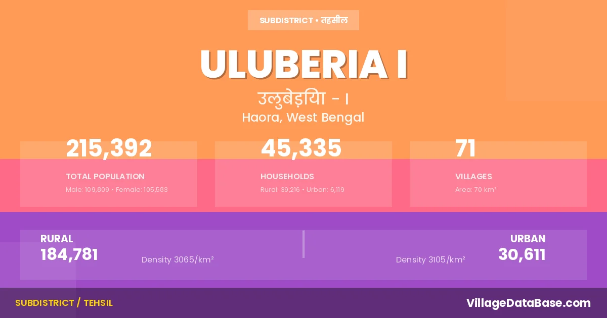
State → West Bengal
Uluberia I is a town and Subdivision in the Haora district of the West Bengal. In India, a Subdivision is a subdivision of a district responsible for the administration and revenue collection of a specific area within the district. Subdivisions play a crucial role in the local governance structure, contributing significantly to the development and administration of their communities.
According to the 2011 census The total area of Uluberia I Subdivision is 70 km², with a population of 215392 people. The population density is 3,071 inhabitants per square kilometre, and there are approximately 45335 houses in the sub district.
Uluberia I Subdivision comprises about 71 villages. Below is a list of these villages along with information about their respective gram panchayats and the nearest town:
| # | Village Name | Gram Panchayat | Nearest Town |
|---|---|---|---|
| 1 | Alipukur | Kalinagar | Uluberia I |
| 2 | Amritasal | Tapna | Uluberia (11 km) |
| 3 | Amsa | Bahira | Uluberia (8 km) |
| 4 | Amtala | Hatgachha Ii | Uluberia I |
| 5 | Baggachha | Bahira | Uluberia (6 km) |
| 6 | Bahira | Bahira | Uluberia (6 km) |
| 7 | Baikhali | Dhulasimla | Uluberia (8 km) |
| 8 | Balarampur | Antila | Uluneria (11 km) |
| 9 | Bar Mongrajpur | Hatgachha I | Uluberia (14 km) |
| 10 | Bara Gachha | Baragachhia I | Uluberia (8 km) |
| 11 | Baragohal | Maheshpur | Uluberia (8 km) |
| 12 | Barmouberia | Maheshpur | Uluberia (13 km) |
| 13 | Bauria | Uluberia (17 km) | |
| 14 | Beraberia | Hatgachha Ii | Uluberia I |
| 15 | Bhekutal | Tapna | Ulueria (12 km) |
| 16 | Birpur | Bahira | Uluberia (6 km) |
| 17 | Birsibpur | Maheshpur | Uluberia (8 km) |
| 18 | Bishweshwarpur | Tapna | Uluberria (14 km) |
| 19 | Chandipur | Belari | Uluberia I |
| 20 | Dadpur | Dhulasimla | Uluberia (8 km) |
| 21 | Dahuka Nischindipur | Hatgachha Ii | Uluberia (14 km) |
| 22 | Dakshin Ramchandrapur | Heerapur | Uluberia (15 km) |
| 23 | Dalsalap | Maheshpur | Uluberia (8 km) |
| 24 | Damodarpur | Bahira | Uluberia (6 km) |
| 25 | Dhulasimla | Dhulasimla | Uluberia I |
| 26 | Gadaipur | Hatgachha Ii | Uluberia (17 km) |
| 27 | Gauripur | Heerapur | Uluberia (10 km) |
| 28 | Gharsalap | Bahira | Uluberia (6 km) |
| 29 | Ghatampur | Maheshpur | Uluberia (10 km) |
| 30 | Gudar | Bahira | Uluberia (5 km) |
| 31 | Harinarayan Chak | Chandipur | Uluberia (6 km) |
| 32 | Hatgachha | Jorhat | Uluberia (13 km) |
| 33 | Hiraganja | Heerapur | Uluberia (12 km) |
| 34 | Hirapur | Heerapur | Uluberia I |
| 35 | Janbar | Chandipur | Uluberia (9 km) |
| 36 | Jaynagar | Chandipur | Uluberia (12 km) |
| 37 | Jayrampur | Chandipur | Uluberia (13 km) |
| 38 | Kaijuri | Maheshpur | Uluberia I |
| 39 | Kajiakhali | Heerapur | Uluberia (9 km) |
| 40 | Kalinagar | Kalinagar | Uluberia (2 km) |
| 41 | Kansona | Hatgachha I | Uluberia (12 km) |
| 42 | Kashmul | Tapna | Uluberia (15 km) |
| 43 | Kashyappur | Chandipur | Uluberia (10 km) |
| 44 | Kasipur | Dhulasimla | Uluberia (8 km) |
| 45 | Khan Jadapur | Bantul Baidyanathpur | Uluberia (6 km) |
| 46 | Kharia | Balichak | Uluberia (13 km) |
| 47 | Kulgachhi | Chandipur | Uluberia (9 km) |
| 48 | Lalitagari | Hatgachha I | Uluberia (12 km) |
| 49 | Lohanagar | Hatgachha I | Uluneria (12 km) |
| 50 | Madai | Heerapur | Uluberia (16 km) |
| 51 | Madhabpur | Chandipur | Uluberia (11 km) |
| 52 | Mahespur | Maheshpur | Uluberia (5 km) |
| 53 | Mahisali | Bahira | Uluberia (6 km) |
| 54 | Malanchabere | Maheshpur | Uluberia (6 km) |
| 55 | Manikpur | Chandipur | Uluberia (9 km) |
| 56 | Maubesia | Dhulasimla | Uluberia (7 km) |
| 57 | Mayanapur | Hatgachha I | Uluberia (13 km) |
| 58 | Mongrajpur | Hatgachha I | Uluberia (14 km) |
| 59 | Musapur | Bahira | Uluberia (4 km) |
| 60 | Palpara | Dhulasimla | Uluberia (8 km) |
| 61 | Panchberia Barberia | Maheshpur | Uluberia (12 km) |
| 62 | Pirpur | Chandipur | Uluberia (11 km) |
| 63 | Prasadpur | Chandipur | Uluberia (10 km) |
| 64 | Rangmahal | Dhulasimla | Uluberia (9 km) |
| 65 | Rauta | Maheshpur | Uluberia (5 km) |
| 66 | Samruk | Tapna | Uluberia (15 km) |
| 67 | Srikrishnapur | Chandipur | Uluberia (9 km) |
| 68 | Tapna | Tapna | Uluberia (10 km) |
| 69 | Tildari | Maheshpur | Uluberia (8 km) |
| 70 | Tiorpara | Dhulasimla | Uluberia (11 km) |
| 71 | Uttar Ramchandrapur | Anulia | Uluberia (8 km) |
The population is distributed between urban and rural areas as follows:
| Particulars | Rural | Urban | Total |
|---|---|---|---|
| Total Population | 184781 | 30611 | 215392 |
| Male Population | 94250 | 15559 | 109809 |
| Female Population | 90531 | 15052 | 105583 | Population Density | 3065 / km² | 3105 / km² | 3,071 / km² |
The distribution of households in the Uluberia I is:
| Rural Households | Urban Households | Total Households |
|---|---|---|
| 39216 | 6119 | 45335 |
Q: What is Uluberia I?
A: Uluberia I is a town and in the Haora district of the West Bengal.
Q: What is the total area of Uluberia I Subdivision?
A: The total area of Uluberia I Subdivision is 70 km².
Q: What is the population of Uluberia I Subdivision according to the 2011 census?
A: According to the 2011 census, the population of Uluberia I Subdivision is 215392.
Q: What is the population density of Uluberia I Subdivision?
A: The population density of Uluberia I Subdivision is 3,071 inhabitants per square kilometre.
Q: How many houses are there in Uluberia I Subdivision?
A: There are approximately 45335 houses in Uluberia I Subdivision.
Q: How many villages are there in Uluberia I Subdivision?
A: There are about 71 villages in Uluberia I Subdivision.
Q: Which is the largest village by population in Uluberia I Subdivision?
A: The largest village by population in Uluberia I Subdivision is Kalinagar, with 11358 people.
Q: Which is the smallest village by population in Uluberia I Subdivision?
A: The smallest village by population in Uluberia I Subdivision is Alipukur, with 0 people.
Q: Which is the largest village by area in Uluberia I Subdivision?
A: The largest village by area in Uluberia I Subdivision is Kalinagar, with 400 km².
Q: Which is the smallest village by area in Uluberia I Subdivision?
A: The smallest village by area in Uluberia I Subdivision is Alipukur, with 0 km².
Q: What is the male population of Uluberia I Subdivision?
A: The male population of Uluberia I Subdivision is 109809.
Q: What is the female population of Uluberia I Subdivision?
A: The female population of Uluberia I Subdivision is 105583.
Q: How many villages in Uluberia I Subdivision have a population of less than 100?
A: There are 5 villages in Uluberia I Subdivision with a population of less than 100.
Q: How many villages in Uluberia I Subdivision have a population between 500 and 999?
A: There are 4 villages in Uluberia I Subdivision with a population between 500 and 999.
Q: How many villages in Uluberia I Subdivision have a population between 1000 and 1999?
A: There are 18 villages in Uluberia I Subdivision with a population between 1000 and 1999.
Q: How many villages in Uluberia I Subdivision have a population between 2000 and 2999?
A: There is 21 village in Uluberia I Subdivision with a population between 2000 and 2999.
Q: How many villages in Uluberia I Subdivision have a population between 3000 and 3999?
A: There is 12 village in Uluberia I Subdivision with a population between 3000 and 3999.
Q: How many villages in Uluberia I Subdivision have a population between 4000 and 4999?
A: There is 7 village in Uluberia I Subdivision with a population between 4000 and 4999.
Q: How many villages in Uluberia I Subdivision have a population of 5000 and above?
A: There is 4 village in Uluberia I Subdivision with a population of 5000 and above.
| Total Population | Villages in Sub District Of Uluberia I |
|---|---|
| Less than 100 | 5 |
| 500-999 | 4 |
| 1000-1999 | 18 |
| 2000-2999 | 21 |
| 3000-3999 | 12 |
| 4000-4999 | 7 |
| 5000 And Above | 4 |