Welcome Back

Forgot password?
Don't have an account?
🏘️ Menu
Haora District 0.0 / 5 (0)

Amtala Village Detailed Information

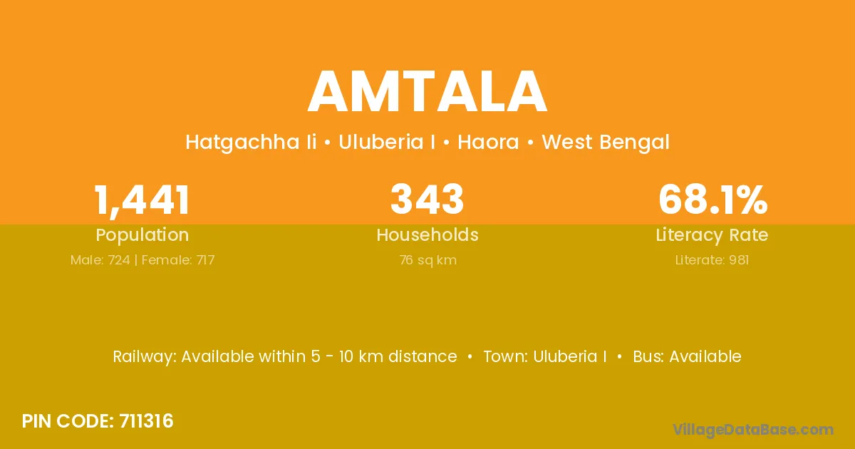
Amtala village is located in the Uluberia I Subdivision of the Haora district in West Bengal .

About Amtala Village

Block / Subdivision → Uluberia I

District → Haora

State → West Bengal

According to Census 2011 information, the village code of Amtala village is 711316.

Amtala village has a total population of 1,441 people, of which 724 are males and 717 are females.

The literacy rate of Amtala village is 68.08%. Male literacy stands at 71.96% and female literacy at 64.16%.

There are approximately 343 households in Amtala village.

Uluberia I is the nearest town to Amtala village for major economic activities

Population of Amtala Village

The population of Amtala village is distributed between literate and illiterate residents as follows:

Population distribution of Amtala village by literacy and gender
Particulars Male Female Total
Literate 521 460 981
Illiterate 203 257 460
Total 724 717 1,441

Source: Census 2011

Nearby Villages

List of nearby villages around Amtala village
Village District
Amritasal Haora
Bar Mongrajpur Haora
Bauria Dumka
Bauria Mahrajganj
Bauria Haora
Beraberia Haora
Beraberia North Twenty Four Parganas
Beraberia Purba Medinipur
Beraberia North Twenty Four Parganas
Beraberia Purba Medinipur
Bhekutal Haora
Bishweshwarpur Haora
Bishweshwarpur South Twenty Four Parganas
Dahuka Nischindipur Haora
Gadaipur Buxar
Gadaipur Buxar
Gadaipur Patna
Gadaipur Gurgaon
Gadaipur Jalandhar
Gadaipur Jalandhar
Gadaipur Ballia
Gadaipur Ghazipur
Gadaipur Ghazipur
Gadaipur Hardoi
Gadaipur Kanpur Dehat
Gadaipur Haora
Gadaipur Murshidabad
Gadaipur Paschim Medinipur
Gadaipur Murshidabad
Gadaipur Paschim Medinipur
Mongrajpur Haora
Rangmahal Baksa
Rangmahal Kamrup
Rangmahal Haora
Samruk Haora

Frequently Asked Questions

Amtala village is located in the Uluberia I Subdivision of the Haora district in West Bengal.
The total population is 1,441 people.
724 males and 717 females.
The literacy rate is 68.08%.
Male literacy rate is 71.96%, and female literacy rate is 64.16%.
There are approximately 343 houses in Amtala village.
Uluberia I is the nearest town, located approximately km away.

Reviews and Ratings

0.0 / 5 (0 reviews)

Reviews

No reviews yet. Be the first to review this village!

Amtala Village Statistics

Population
1441
Area
76 km²
Households
343
Nearest Town :
Uluberia I

Quick Information

State / UT : West Bengal
Pincode : 711316
Total Area : 76 km²
Population : 1441
Households : 343
Gram Panchayat : Hatgachha Ii
Nearest Town : Uluberia I

Connectivity of Amtala

🚂 Railway Station

Available within 5 - 10 km distance

🚌 Public Bus Service

Available within 10+ km distance

🚌 Private Bus Service

Available within 5 - 10 km distance

Need Help?

Contact local tourism office for assistance