Goghat I: A Town and Subdivision in Hugli district
District → Hugli
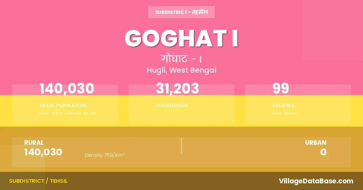
State → West Bengal
Goghat I is a town and Subdivision in the Hugli district of the West Bengal. In India, a Subdivision is a subdivision of a district responsible for the administration and revenue collection of a specific area within the district. Subdivisions play a crucial role in the local governance structure, contributing significantly to the development and administration of their communities.
According to the 2011 census The total area of Goghat I Subdivision is 184 km², with a population of 140030 people. The population density is 759 inhabitants per square kilometre, and there are approximately 31203 houses in the sub district.
Goghat I Subdivision comprises about 99 villages. Below is a list of these villages along with information about their respective gram panchayats and the nearest town:
| # | Village Name | Gram Panchayat | Nearest Town |
|---|---|---|---|
| 1 | Adra | Bhadur | Arambag (15 km) |
| 2 | Amadpur | Goghat | Arambagh (10 km) |
| 3 | Amdoba | Saora | Arambag (12 km) |
| 4 | Anandapur | Saora | Arambag (15 km) |
| 5 | Arazi Surjyapur | Bhadur | Arambagh (13 km) |
| 6 | Badla | Kumarsa | Arambagh (10 km) |
| 7 | Bajua | Raghubati | Arambag (14 km) |
| 8 | Bali | Bali | Arambag (12 km) |
| 9 | Balirchak | Bhadur | Goghat I |
| 10 | Ballabhbati | Kumarsa | Arambagh (5 km) |
| 11 | Bamunia | Goghat | Arambagh (10 km) |
| 12 | Bara Kumursa | Saora | Arambag (13 km) |
| 13 | Barama | Saora | Arambagh (13 km) |
| 14 | Barul | Raghubati | Arambagh (15 km) |
| 15 | Belekusuma | Saora | Arambag (17 km) |
| 16 | Beli | Bhadur | Arambagh (6 km) |
| 17 | Belibela | Kumarsa | Arambagh (4 km) |
| 18 | Bhabadighi | Goghat | Arambagh (16 km) |
| 19 | Bhadur | Bhadur | Arambag (13 km) |
| 20 | Bhanjapara | Bhadur | Arambagh (6 km) |
| 21 | Bijalkona | Raghubati | Arambag (16 km) |
| 22 | Birampur | Bhadur | Arambagh (10 km) |
| 23 | Brahmangram | Goghat | Arambagh (16 km) |
| 24 | Buintya | Goghat | Arambag (16 km) |
| 25 | Chak Hari | Kumarsa | Arambagh (10 km) |
| 26 | Chak Mamrej | Saora | Arambagh (15 km) |
| 27 | Chak Netara | Bhadur | Arambagh (8 km) |
| 28 | Chatra | Bhadur | Arambagh (6 km) |
| 29 | Dahiakanda | Goghat | Arambagh (15 km) |
| 30 | Dakshin Balarampur | Saora | Arambag (17 km) |
| 31 | Damodarpur | Bali | Arambag (20 km) |
| 32 | Darinakunda | Nakunda | Arambagh (16 km) |
| 33 | Dewan Chak | Nakunda | Ramjibanpur (10 km) |
| 34 | Dhulepur | Kumarsa | Arambagh (10 km) |
| 35 | Dighara | Bali | Arambagh (10 km) |
| 36 | Dumurpara | Nakunda | Arambag (19 km) |
| 37 | Ganeshbati | Raghubati | Arambagh (12 km) |
| 38 | Goalpara | Saora | Arambag (19 km) |
| 39 | Gobindapur | Bhadur | Arambagh (10 km) |
| 40 | Goghat | Goghat | Arambag (12 km) |
| 41 | Gohalisanra | Bali | Arambag (12 km) |
| 42 | Gohalpota | Nakunda | Arambagh (18 km) |
| 43 | Golpur | Raghubati | Arambagh (13 km) |
| 44 | Gopalbati | Goghat | Arambagh (10 km) |
| 45 | Hariharpur | Kumarsa | Arambagh (5 km) |
| 46 | Harischandrapur | Raghubati | Arambagh (18 km) |
| 47 | Jagatpur | Bali | Arambag (14 km) |
| 48 | Janakiballabhpur | Goghat | Goghat I |
| 49 | Jaykrishnapur | Kumarsa | Arambagh (10 km) |
| 50 | Jot Mahabat | Saora | Arambag (18 km) |
| 51 | Kalagachhia | Bali | Arambag (14 km) |
| 52 | Kamche | Goghat | Arambagh (11 km) |
| 53 | Kanaipur | Bali | Arambagh (12 km) |
| 54 | Kantali | Goghat | Arambagh (15 km) |
| 55 | Khanati | Goghat | Arambagh (10 km) |
| 56 | Khatgram | Raghubati | Arambag (17 km) |
| 57 | Khilgram | Bali | Arambagh (12 km) |
| 58 | Khorda Kanpur | Kumarsa | Arambagh (10 km) |
| 59 | Kota | Nakunda | Arambag (20 km) |
| 60 | Kulia | Nakunda | Arambag (10 km) |
| 61 | Kumursa | Kumarsa | Arambagh (10 km) |
| 62 | Kurmana | Goghat | Arambagh (10 km) |
| 63 | Lakshmipur | Bali | Arambagh (10 km) |
| 64 | Madanmohanpur | Goghat | Arambagh (15 km) |
| 65 | Madina | Raghubati | Arambagh (12 km) |
| 66 | Mandalghanti | Bhadur | Arambag (14 km) |
| 67 | Mathura | Kumarsa | Arambagh (5 km) |
| 68 | Methul | Bhadur | Arambagh (10 km) |
| 69 | Mirga | Bhadur | Arambagh (7 km) |
| 70 | Mirzzapur | Bali | Arambag (19 km) |
| 71 | Mohanpur | Saora | Arambagh (12 km) |
| 72 | Muktarpur | Saora | Arambag (17 km) |
| 73 | Nabasan | Goghat | Arambagh (12 km) |
| 74 | Nakunda | Nakunda | Arambagh (16 km) |
| 75 | Palpukur | Raghubati | Arambagh (17 km) |
| 76 | Patulsara | Kumarsa | Arambagh (4 km) |
| 77 | Penchera | Bali | Arambag (18 km) |
| 78 | Pirmallik | Raghubati | Arambagh (12 km) |
| 79 | Purbba Amarpur | Kumarsa | Arambagh (10 km) |
| 80 | Pyarinagar | Bhadur | Arambagh (14 km) |
| 81 | Radhaballabhpur | Bali | Arambag (18 km) |
| 82 | Raghubati | Raghubati | Arambagh (13 km) |
| 83 | Rajgram | Raghubati | Arambagh (12 km) |
| 84 | Ratanpur | Raghubati | Arambagh (12 km) |
| 85 | Rautara | Nakunda | Arambag (19 km) |
| 86 | Santa | Raghubati | Arambagh (14 km) |
| 87 | Santoshpur | Raghubati | Arambag (15 km) |
| 88 | Saora | Saora | Arambag (18 km) |
| 89 | Sekati | Bhadur | Arambag (15 km) |
| 90 | Shancha | Raghubati | Arambagh (13 km) |
| 91 | Shyambati | Kumarsa | Arambagh (10 km) |
| 92 | Sitanagar | Raghubati | Arambagh (12 km) |
| 93 | Sulut | Raghubati | Arambag (16 km) |
| 94 | Sunia | Goghat | Arambagh (13 km) |
| 95 | Surjyapur | Bhadur | Arambagh (10 km) |
| 96 | Syamballabpur | Bali | Arambag (20 km) |
| 97 | Teligram | Kumarsa | Arambagh (10 km) |
| 98 | Udayrajpur | Bali | Arambag (19 km) |
| 99 | Uttar Balarampur | Bhadur | Arambagh (8 km) |
The population is distributed between urban and rural areas as follows:
| Particulars | Rural | Urban | Total |
|---|---|---|---|
| Total Population | 140030 | 0 | 140030 |
| Male Population | 71804 | 0 | 71804 |
| Female Population | 68226 | 0 | 68226 | Population Density | 759 / km² | 759 / km² |
The distribution of households in the Goghat I is:
| Rural Households | Urban Households | Total Households |
|---|---|---|
| 31203 | 0 | 31203 |
Q: What is Goghat I?
A: Goghat I is a town and in the Hugli district of the West Bengal.
Q: What is the total area of Goghat I Subdivision?
A: The total area of Goghat I Subdivision is 184 km².
Q: What is the population of Goghat I Subdivision according to the 2011 census?
A: According to the 2011 census, the population of Goghat I Subdivision is 140030.
Q: What is the population density of Goghat I Subdivision?
A: The population density of Goghat I Subdivision is 759 inhabitants per square kilometre.
Q: How many houses are there in Goghat I Subdivision?
A: There are approximately 31203 houses in Goghat I Subdivision.
Q: How many villages are there in Goghat I Subdivision?
A: There are about 99 villages in Goghat I Subdivision.
Q: Which is the largest village by population in Goghat I Subdivision?
A: The largest village by population in Goghat I Subdivision is Goghat, with 5495 people.
Q: Which is the smallest village by population in Goghat I Subdivision?
A: The smallest village by population in Goghat I Subdivision is Balirchak, with 0 people.
Q: Which is the largest village by area in Goghat I Subdivision?
A: The largest village by area in Goghat I Subdivision is Kumursa, with 712 km².
Q: Which is the smallest village by area in Goghat I Subdivision?
A: The smallest village by area in Goghat I Subdivision is Balirchak, with 40 km².
Q: What is the population distribution between urban and rural areas in Goghat I Subdivision?
A: The population distribution in Goghat I Subdivision is entirely rural, with a total rural population of 140030.
Q: What is the male population of Goghat I Subdivision?
A: The male population of Goghat I Subdivision is 71804.
Q: What is the female population of Goghat I Subdivision?
A: The female population of Goghat I Subdivision is 68226.
Q: How is the household distribution in Goghat I Subdivision?
A: The household distribution in Goghat I Subdivision is entirely rural, with a total of 31203 households.
Q: How many villages in Goghat I Subdivision have a population of less than 100?
A: There are 2 villages in Goghat I Subdivision with a population of less than 100.
Q: How many villages in Goghat I Subdivision have a population between 100 and 499?
A: There are 18 villages in Goghat I Subdivision with a population between 100 and 499.
Q: How many villages in Goghat I Subdivision have a population between 500 and 999?
A: There are 21 villages in Goghat I Subdivision with a population between 500 and 999.
Q: How many villages in Goghat I Subdivision have a population between 1000 and 1999?
A: There are 37 villages in Goghat I Subdivision with a population between 1000 and 1999.
Q: How many villages in Goghat I Subdivision have a population between 2000 and 2999?
A: There is 14 village in Goghat I Subdivision with a population between 2000 and 2999.
Q: How many villages in Goghat I Subdivision have a population between 3000 and 3999?
A: There is 1 village in Goghat I Subdivision with a population between 3000 and 3999.
Q: How many villages in Goghat I Subdivision have a population between 4000 and 4999?
A: There is 5 village in Goghat I Subdivision with a population between 4000 and 4999.
Q: How many villages in Goghat I Subdivision have a population of 5000 and above?
A: There is 1 village in Goghat I Subdivision with a population of 5000 and above.
| Total Population | Villages in Sub District Of Goghat I |
|---|---|
| Less than 100 | 2 |
| 100-499 | 18 |
| 500-999 | 21 |
| 1000-1999 | 37 |
| 2000-2999 | 14 |
| 3000-3999 | 1 |
| 4000-4999 | 5 |
| 5000 And Above | 1 |