District → Hugli
Hugli is a district in the West Bengal of India. Covering a total area of 3149 km², Hugli is home to a population of 5519145 people as per the 2011 census. The district has a population density of 1753 inhabitants per square kilometre and comprises about 1287423 houses. district includes approximately 1842 villages.
For administrative purposes, the Hugli district is divided into Subdivisions, Blocks, Police Stations (PS), and Community Development Blocks (C.D.Blocks). In India, a C.D.Block represents the next level of administrative division after the Subdivision in many regions. Its important to note that in some Indian states, C.D.Blocks are synonymous with Subdivisions.
A C.D.Block is a designated rural area for administration and development in India. It is managed by a Block Development Officer (BDO) and encompasses several gram panchayats, which are local administrative units at the village level.
The largest Subdivision in Hugli district is Polba Dadpur, which spans an area of 290 km², while Serampur Uttarpara is the smallest Subdivision with an area of 33 km². Dhaniakhali is also the most populous Subdivision with 320534 people, whereas Goghat I is the least populous with 140030 people. There are 18 Subdivisions in Hugli district.
| # | Subdivisions(CD Block) | Area (km²) | Population (2011) | Density (km²) |
|---|---|---|---|---|
| 1 | Arambag | 276 | 285207 | 1,033 |
| 2 | Balagarh | 199 | 228998 | 1,152 |
| 3 | Chanditala I | 94 | 179825 | 1,914 |
| 4 | Chanditala II | 50 | 158396 | 3,174 |
| 5 | Chinsurah Magra | 65 | 244383 | 3,763 |
| 6 | Dhaniakhali | 277 | 320534 | 1,156 |
| 7 | Goghat I | 184 | 140030 | 759 |
| 8 | Goghat II | 190 | 160585 | 843 |
| 9 | Haripal | 185 | 261073 | 1,409 |
| 10 | Jangipara | 164 | 221578 | 1,354 |
| 11 | Khanakul I | 175 | 254434 | 1,457 |
| 12 | Khanakul II | 124 | 184734 | 1,494 |
| 13 | Pandua | 284 | 316197 | 1,114 |
| 14 | Polba Dadpur | 290 | 263555 | 909 |
| 15 | Pursura | 102 | 173437 | 1,699 |
| 16 | Serampur Uttarpara | 33 | 152266 | 4,592 |
| 17 | Singur | 165 | 276413 | 1,676 |
| 18 | Tarakeswar | 116 | 179148 | 1,540 |
The population is distributed between urban and rural areas as follows:
| Particulars | Rural | Urban | Total |
|---|---|---|---|
| Total Population | 3390646 | 2128499 | 5519145 |
| Male Population | 1722945 | 1091708 | 2814653 |
| Female Population | 1667701 | 1036791 | 2704492 | Population Density | 1202 / km² | 6469 / km² | 1753 / km² |
The distribution of households in the Hugli is:
| Rural Households | Urban Households | Total Households |
|---|---|---|
| 781480 | 505943 | 1287423 |
Showing 1 of 1 places
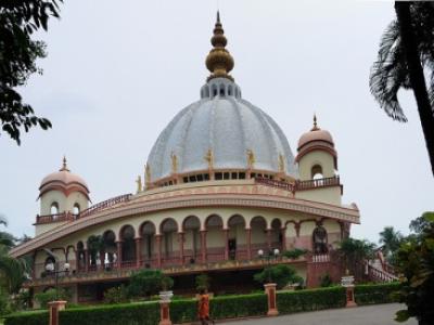
The Nadia, Mayapur is a prominent Temple dedicated to West Bengal located in Mayapur, Hugli, West Bengal, India. The be
Q: What is the total area of Hugli district?
A: The total area of Hugli district is 3149 km².
Q: What is the population of Hugli district according to the 2011 census?
A: According to the 2011 census, the population of Hugli district is 5519145.
Q: How many villages are there in Hugli district?
A: There are approximately 1842 villages in Hugli district.
Q: What is the population density of Hugli district?
A: The population density of Hugli district is 1753 inhabitants per square kilometre.
Q: How many houses are there in Hugli district?
A: There are about 1287423 houses in Hugli district.
Q: How is the Hugli district administratively divided?
A: For administrative purposes, Hugli district is divided into Subdivisions, Blocks, Police Stations (PS), and Community Development Blocks (C.D.Blocks).
Q: What is a C.D.Block in India?
A: A C.D.Block (Community Development Block) is a designated rural area for administration and development in India, managed by a Block Development Officer (BDO) and encompassing several gram panchayats.
Q: Which is the largest Subdivision in Hugli district by area?
A: The largest Subdivision in Hugli district by area is Polba Dadpur, which spans an area of 290 km².
Q: Which is the smallest Subdivision in Hugli district by area?
A: The smallest Subdivision in Hugli district by area is Serampur Uttarpara, with an area of 33 km².
Q: Which Subdivision in Hugli district has the largest population?
A: The Subdivision with the largest population in Hugli district is Dhaniakhali, with a population of 320534 people.
Q: Which Subdivision in Hugli district has the smallest population?
A: The Subdivision with the smallest population in Hugli district is , with a population of 140030 people.
Q: How many Subdivisions are there in Hugli district?
A: There are 18 Subdivisions in Hugli district.
Q: What is the male population of Hugli district?
A: The male population of Hugli district is 20,727.
Q: What is the female population of Hugli district?
A: The female population of Hugli district is 16,115.
Q: How many villages in Hugli district have a population of less than 100?
A: There are 107 villages in Hugli district with a population of less than 100.
Q: How many villages in Hugli district have a population between 100 and 499?
A: There are 219 villages in Hugli district with a population between 100 and 499.
Q: How many villages in Hugli district have a population between 500 and 999?
A: There are 397 villages in Hugli district with a population between 500 and 999.
Q: How many villages in Hugli district have a population between 1000 and 1999?
A: There are 629 villages in Hugli district with a population between 1000 and 1999.
Q: How many villages in Hugli district have a population between 2000 and 2999?
A: There is 282 village in Hugli district with a population between 2000 and 2999.
Q: How many villages in Hugli district have a population between 3000 and 3999?
A: There is 136 village in Hugli district with a population between 3000 and 3999.
Q: How many villages in Hugli district have a population between 4000 and 4999?
A: There is 71 village in Hugli district with a population between 4000 and 4999.
Q: How many villages in Hugli district have a population of 5000 and above?
A: There is 90 village in Hugli district with a population of 5000 and above.
| Total Population | Villages in Sub District Of Hugli |
|---|---|
| Less than 100 | 107 |
| 100-499 | 219 |
| 500-999 | 397 |
| 1000-1999 | 629 |
| 2000-2999 | 282 |
| 3000-3999 | 136 |
| 4000-4999 | 71 |
| 5000 And Above | 90 |