Goghat II: A Town and Subdivision in Hugli district
District → Hugli
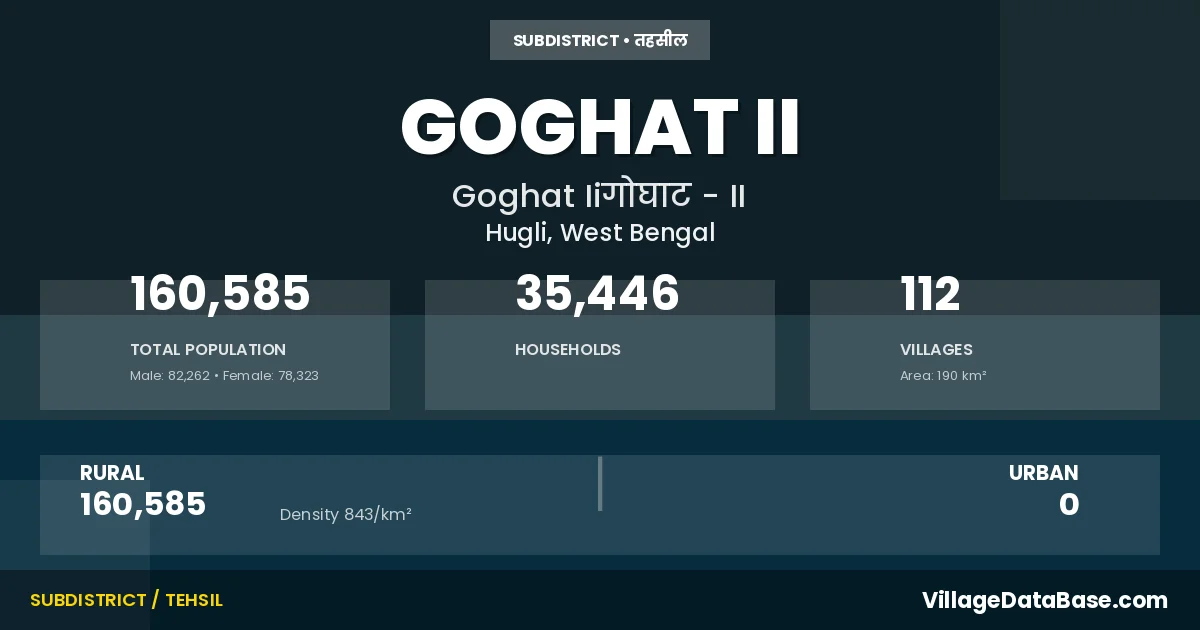
State → West Bengal
Goghat II is a town and Subdivision in the Hugli district of the West Bengal. In India, a Subdivision is a subdivision of a district responsible for the administration and revenue collection of a specific area within the district. Subdivisions play a crucial role in the local governance structure, contributing significantly to the development and administration of their communities.
According to the 2011 census The total area of Goghat II Subdivision is 190 km², with a population of 160585 people. The population density is 843 inhabitants per square kilometre, and there are approximately 35446 houses in the sub district.
Goghat II Subdivision comprises about 112 villages. Below is a list of these villages along with information about their respective gram panchayats and the nearest town:
| # | Village Name | Gram Panchayat | Nearest Town |
|---|---|---|---|
| 1 | Agai | Bengai | Arambagh (10 km) |
| 2 | Ambaula | Kumarganj | Arambagh (22 km) |
| 3 | Andua | Shyambazar | Arambagh (26 km) |
| 4 | Anupnagar | Paschimpara | Ranjibanpur (5 km) |
| 5 | Anur | Kamarpukur | Arambagh (20 km) |
| 6 | Arazi Kirttibaspur | Mandaran | Arambagh (19 km) |
| 7 | Ashpur | Kumarganj | Arambagh (24 km) |
| 8 | Babuimari | Mandaran | Goghat Ii |
| 9 | Baburampur | Paschimpara | Ramjibanpur (10 km) |
| 10 | Badanganj | Badanganj Falui I | Ramjibanpur (12 km) |
| 11 | Bahagal | Hazipur | Arambag (11 km) |
| 12 | Balitakunda | Kumarganj | Arambagh (23 km) |
| 13 | Bara Salabeltala | Badanganj Falui I | Ranjibanpur (11 km) |
| 14 | Beldiha | Shyambazar | Arambagh (29 km) |
| 15 | Belepara | Kamarpukur | Arambagh (18 km) |
| 16 | Belun | Kumarganj | Arambagh (20 km) |
| 17 | Bengai | Bengai | Arambagh (10 km) |
| 18 | Betbani | Mandaran | Arambagh (18 km) |
| 19 | Betra | Badanganj Falui Ii | Arambagh (10 km) |
| 20 | Bhagabanpur | Mandaran | Arambagh (20 km) |
| 21 | Bhurkunda | Kumarganj | Arambagh (21 km) |
| 22 | Chakran | Badanganj Falui Ii | Arambagh (10 km) |
| 23 | Chandpur | Hazipur | Arambag (11 km) |
| 24 | Dakshin Arjungaria | Hazipur | Ramjibanpur (5 km) |
| 25 | Dakshin Sainte | Mandaran | Arambag (23 km) |
| 26 | Dariahar | Hazipur | Ramjibanpur (5 km) |
| 27 | Dashghara | Kamarpukur | Arambagh (15 km) |
| 28 | Datpur | Hazipur | Arambag (11 km) |
| 29 | Daulatbati | Bengai | Arambagh (10 km) |
| 30 | Debkhanda | Hazipur | Arambag (11 km) |
| 31 | Dharmmapur | Shyambazar | Arambag (25 km) |
| 32 | Durgapur | Kamarpukur | Arambagh (19 km) |
| 33 | Dwariapur | Kamarpukur | Arambagh (20 km) |
| 34 | Dwaripara | Badanganj Falui Ii | Arambagh (10 km) |
| 35 | Fului | Badanganj Falui I | Arambagh (30 km) |
| 36 | Gar Mandaran | Mandaran | Arambagh (20 km) |
| 37 | Gauripur | Bengai | Arambagh (10 km) |
| 38 | Gotai | Bengai | Arambagh (10 km) |
| 39 | Gurulia Bhatsala | Paschimpara | Ranjibanpur (10 km) |
| 40 | Harihar | Hazipur | Arambag (11 km) |
| 41 | Harisabha | Kamarpukur | Atambagh (15 km) |
| 42 | Hazipur | Hazipur | Arambag (11 km) |
| 43 | Idalbati | Bengai | Arambagh (10 km) |
| 44 | Indira | Kamarpukur | Arambagh (15 km) |
| 45 | Jharia | Paschimpara | Arambagh (11 km) |
| 46 | Jharikhanda | Kumarganj | Arambagh (23 km) |
| 47 | Jitarpur | Kumarganj | Arambagh (24 km) |
| 48 | Jotchandi | Bengai | Arambagh (10 km) |
| 49 | Kajla | Mandaran | Arambagh (10 km) |
| 50 | Kamala | Kumarganj | Arambagh (24 km) |
| 51 | Kamarpukur | Kamarpukur | Arambagh (15 km) |
| 52 | Kantagarya | Mandaran | Arambag (19 km) |
| 53 | Kapsit | Kamarpukur | Arambagh (20 km) |
| 54 | Karnapur | Paschimpara | Ranjibanpur (10 km) |
| 55 | Kayapat | Badanganj Falui Ii | Arambagh (10 km) |
| 56 | Kayrakhali | Mandaran | Arambag (21 km) |
| 57 | Khatul | Bengai | Arambagh (10 km) |
| 58 | Khejurbandi | Shyambazar | Arambagh (22 km) |
| 59 | Kokandi | Badanganj Falui Ii | Arambagh (10 km) |
| 60 | Kotai | Kumarganj | Arambagh (18 km) |
| 61 | Krishnaganj | Badanganj Falui I | Ranjibanpur (13 km) |
| 62 | Krittibaspur | Mandaran | Arambagh (18 km) |
| 63 | Kuchedahari | Paschimpara | Ramjibanpur (10 km) |
| 64 | Kultala | Paschimpara | Ranjibanpur (5 km) |
| 65 | Kumarganj | Kumarganj | Arambagh (20 km) |
| 66 | Kurchigaria | Hazipur | Ramjibanpur (7 km) |
| 67 | Laluka | Mandaran | Arambagh (19 km) |
| 68 | Laskarpukur | Shyambazar | Arambagh (21 km) |
| 69 | Madhubati | Kamarpukur | Arambagh (15 km) |
| 70 | Mamudpur | Shyambazar | Arambagh (22 km) |
| 71 | Mandala | Hazipur | Arambag (11 km) |
| 72 | Masidbera | Kumarganj | Arambagh (23 km) |
| 73 | Maynadanga | Hazipur | Ramjibanpur (5 km) |
| 74 | Meherbanpur | Shyambazar | Arambagh (19 km) |
| 75 | Mulluk | Shyambazar | Arambagh (20 km) |
| 76 | Naldubi | Mandaran | Arambagh (18 km) |
| 77 | Naraharbati | Bengai | Arambagh (10 km) |
| 78 | Narasinbati | Bengai | Arambagh (10 km) |
| 79 | Paba | Hazipur | Ramjibanpur (5 km) |
| 80 | Pandugram | Shyambazar | Arambagh (25 km) |
| 81 | Paschim Amarpur | Kamarpukur | Arambagh (17 km) |
| 82 | Paschim Chakla | Kumarganj | Arambagh (24 km) |
| 83 | Paschim Para | Paschimpara | Ramjibanpur (5 km) |
| 84 | Pukhuria | Kamarpukur | Arambagh (20 km) |
| 85 | Pundahit | Kumarganj | Arambagh (20 km) |
| 86 | Punia | Kumarganj | Arambagh (26 km) |
| 87 | Purba Chakla | Kumarganj | Arambagh (22 km) |
| 88 | Raghunathpur | Kamarpukur | Arambagh (15 km) |
| 89 | Rangamati | Mandaran | Arambagh (10 km) |
| 90 | Rayan | Kumarganj | Arambagh (22 km) |
| 91 | Ria | Kumarganj | Arambagh (19 km) |
| 92 | Samantakhanda | Bengai | Arambagh (10 km) |
| 93 | Satberia | Kamarpukur | Arambagh (18 km) |
| 94 | Selampur | Badanganj Falui Ii | Arambagh (10 km) |
| 95 | Senai | Bengai | Arambagh (10 km) |
| 96 | Shalikona | Kumarganj | Arambagh (22 km) |
| 97 | Shaljhar | Bengai | Arambagh (10 km) |
| 98 | Shantipur | Paschimpara | Arambagh (10 km) |
| 99 | Shripur | Kamarpukur | Arambagh (15 km) |
| 100 | Shyambazar | Shyambazar | Arambagh (28 km) |
| 101 | Shyampur | Badanganj Falui Ii | Arambagh (10 km) |
| 102 | Sikil Beldiha | Badanganj Falui I | Ranjibanpur (11 km) |
| 103 | Sinrapur | Mandaran | Arambagh (20 km) |
| 104 | Subir Chak | Kamarpukur | Arambagh (19 km) |
| 105 | Sundarpur | Paschimpara | Arambagh (10 km) |
| 106 | Tarahat | Mandaran | Arambagh (21 km) |
| 107 | Tarui | Kamarpukur | Arambagh (16 km) |
| 108 | Tehure | Hazipur | Arambag (11 km) |
| 109 | Tilari | Badanganj Falui Ii | Arambagh (10 km) |
| 110 | Tilati | Badanganj Falui Ii | Arambagh (10 km) |
| 111 | Uttar Arjungaria | Hazipur | Goghat Ii |
| 112 | Uttar Sainte | Mandaran | Arambag (22 km) |
The population is distributed between urban and rural areas as follows:
| Particulars | Rural | Urban | Total |
|---|---|---|---|
| Total Population | 160585 | 0 | 160585 |
| Male Population | 82262 | 0 | 82262 |
| Female Population | 78323 | 0 | 78323 | Population Density | 843 / km² | 843 / km² |
The distribution of households in the Goghat II is:
| Rural Households | Urban Households | Total Households |
|---|---|---|
| 35446 | 0 | 35446 |
Q: What is Goghat II?
A: Goghat II is a town and in the Hugli district of the West Bengal.
Q: What is the total area of Goghat II Subdivision?
A: The total area of Goghat II Subdivision is 190 km².
Q: What is the population of Goghat II Subdivision according to the 2011 census?
A: According to the 2011 census, the population of Goghat II Subdivision is 160585.
Q: What is the population density of Goghat II Subdivision?
A: The population density of Goghat II Subdivision is 843 inhabitants per square kilometre.
Q: How many houses are there in Goghat II Subdivision?
A: There are approximately 35446 houses in Goghat II Subdivision.
Q: How many villages are there in Goghat II Subdivision?
A: There are about 112 villages in Goghat II Subdivision.
Q: Which is the largest village by population in Goghat II Subdivision?
A: The largest village by population in Goghat II Subdivision is Shyambazar, with 6293 people.
Q: Which is the smallest village by population in Goghat II Subdivision?
A: The smallest village by population in Goghat II Subdivision is Babuimari, with 0 people.
Q: Which is the largest village by area in Goghat II Subdivision?
A: The largest village by area in Goghat II Subdivision is Fului, with 777 km².
Q: Which is the smallest village by area in Goghat II Subdivision?
A: The smallest village by area in Goghat II Subdivision is Krittibaspur, with 42 km².
Q: What is the population distribution between urban and rural areas in Goghat II Subdivision?
A: The population distribution in Goghat II Subdivision is entirely rural, with a total rural population of 160585.
Q: What is the male population of Goghat II Subdivision?
A: The male population of Goghat II Subdivision is 82262.
Q: What is the female population of Goghat II Subdivision?
A: The female population of Goghat II Subdivision is 78323.
Q: How is the household distribution in Goghat II Subdivision?
A: The household distribution in Goghat II Subdivision is entirely rural, with a total of 35446 households.
Q: How many villages in Goghat II Subdivision have a population of less than 100?
A: There are 4 villages in Goghat II Subdivision with a population of less than 100.
Q: How many villages in Goghat II Subdivision have a population between 100 and 499?
A: There are 26 villages in Goghat II Subdivision with a population between 100 and 499.
Q: How many villages in Goghat II Subdivision have a population between 500 and 999?
A: There are 24 villages in Goghat II Subdivision with a population between 500 and 999.
Q: How many villages in Goghat II Subdivision have a population between 1000 and 1999?
A: There are 29 villages in Goghat II Subdivision with a population between 1000 and 1999.
Q: How many villages in Goghat II Subdivision have a population between 2000 and 2999?
A: There is 15 village in Goghat II Subdivision with a population between 2000 and 2999.
Q: How many villages in Goghat II Subdivision have a population between 3000 and 3999?
A: There is 8 village in Goghat II Subdivision with a population between 3000 and 3999.
Q: How many villages in Goghat II Subdivision have a population between 4000 and 4999?
A: There is 3 village in Goghat II Subdivision with a population between 4000 and 4999.
Q: How many villages in Goghat II Subdivision have a population of 5000 and above?
A: There is 3 village in Goghat II Subdivision with a population of 5000 and above.
| Total Population | Villages in Sub District Of Goghat II |
|---|---|
| Less than 100 | 4 |
| 100-499 | 26 |
| 500-999 | 24 |
| 1000-1999 | 29 |
| 2000-2999 | 15 |
| 3000-3999 | 8 |
| 4000-4999 | 3 |
| 5000 And Above | 3 |