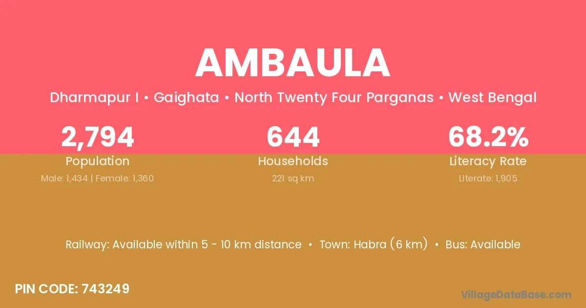
Ambaula village is located in the Goghat II Subdivision of the Hugli district in West Bengal .
Block / Subdivision → Goghat II
District → Hugli
State → West Bengal
According to Census 2011 information, the village code of Ambaula village is 712611.
Ambaula village has a total population of 484 people, of which 248 are males and 236 are females.
The literacy rate of Ambaula village is 67.98%. Male literacy stands at 75.40% and female literacy at 60.17%.
There are approximately 96 households in Ambaula village.
Arambagh (22 km) is the nearest town to Ambaula village for major economic activities and is located approximately 22 km away.
The population of Ambaula village is distributed between literate and illiterate residents as follows:
| Particulars | Male | Female | Total |
|---|---|---|---|
| Literate | 187 | 142 | 329 |
| Illiterate | 61 | 94 | 155 |
| Total | 248 | 236 | 484 |
Source: Census 2011
| Village | District |
|---|---|
| Ashpur | Hugli |
| Belun | Birbhum |
| Belun | Hugli |
| Belun | Hugli |
| Belun | Murshidabad |
| Belun | Murshidabad |
| Belun | Paschim Medinipur |
| Belun | Purba Medinipur |
| Belun | Murshidabad |
| Belun | Murshidabad |
| Belun | Paschim Medinipur |
| Belun | Purba Medinipur |
| Jharikhanda | Hugli |
| Kotai | Hugli |
| Kumarganj | Barddhaman |
| Kumarganj | Dakshin Dinajpur |
| Kumarganj | Hugli |
| Kumarganj | Koch Bihar |
| Kumarganj | Maldah |
| Kumarganj | Maldah |
| Masidbera | Hugli |
| Paschim Chakla | Hugli |
| Pundahit | Hugli |
| Punia | Baksa |
| Punia | Darrang |
| Punia | Udalguri |
| Punia | Barddhaman |
| Punia | Hugli |
| Punia | Murshidabad |
| Punia | Murshidabad |
| Purba Chakla | Hugli |
| Ria | Solan |
| Ria | Baleshwar |
| Ria | Dhenkanal |
| Ria | Dhenkanal |
| Ria | Hugli |
No reviews yet. Be the first to review this village!
Available within 10+ km distance
Available within 5 - 10 km distance
Available within 5 - 10 km distance