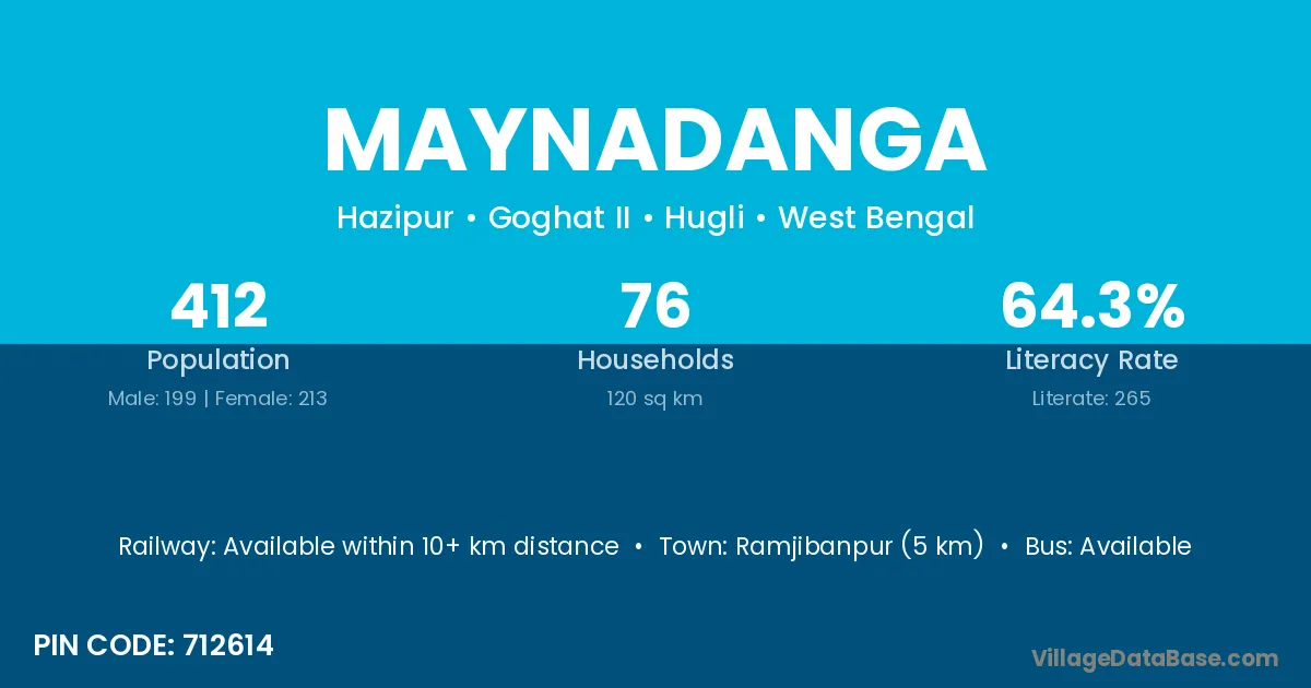
Maynadanga village is located in the Goghat II Subdivision of the Hugli district in West Bengal .
Block / Subdivision → Goghat II
District → Hugli
State → West Bengal
According to Census 2011 information, the village code of Maynadanga village is 712614.
Maynadanga village has a total population of 412 people, of which 199 are males and 213 are females.
The literacy rate of Maynadanga village is 64.32%. Male literacy stands at 75.38% and female literacy at 53.99%.
There are approximately 76 households in Maynadanga village.
Ramjibanpur (5 km) is the nearest town to Maynadanga village for major economic activities and is located approximately 5 km away.
The population of Maynadanga village is distributed between literate and illiterate residents as follows:
| Particulars | Male | Female | Total |
|---|---|---|---|
| Literate | 150 | 115 | 265 |
| Illiterate | 49 | 98 | 147 |
| Total | 199 | 213 | 412 |
Source: Census 2011
| Village | District |
|---|---|
| Bhabapur | Darrang |
| Bhabapur | Baudh |
| Bhabapur | Bankura |
| Bhabapur | Hugli |
| Dakshin Arjungaria | Hugli |
| Dakshin Sainte | Hugli |
| Dariahar | Hugli |
| Kayrakhali | Hugli |
| Kirthi Chandrapur | Hugli |
| Kurchigaria | Hugli |
| Maminpur | Hugli |
| Maminpur | North Twenty Four Parganas |
| Maminpur | North Twenty Four Parganas |
| Maminpur | North Twenty Four Parganas |
| Maminpur | North Twenty Four Parganas |
| Paba | Upper Subansiri |
| Paba | Sirohi |
| Paba | Udaipur |
| Paba | Hugli |
| Par Adra | Hugli |
| Uttar Sainte | Hugli |
No reviews yet. Be the first to review this village!
Available within 10+ km distance
Available within <5 km distance
Available within <5 km distance