Khanakul II: A Town and Subdivision in Hugli district
District → Hugli
State → West Bengal
Khanakul II is a town and Subdivision in the Hugli district of the West Bengal. In India, a Subdivision is a subdivision of a district responsible for the administration and revenue collection of a specific area within the district. Subdivisions play a crucial role in the local governance structure, contributing significantly to the development and administration of their communities.
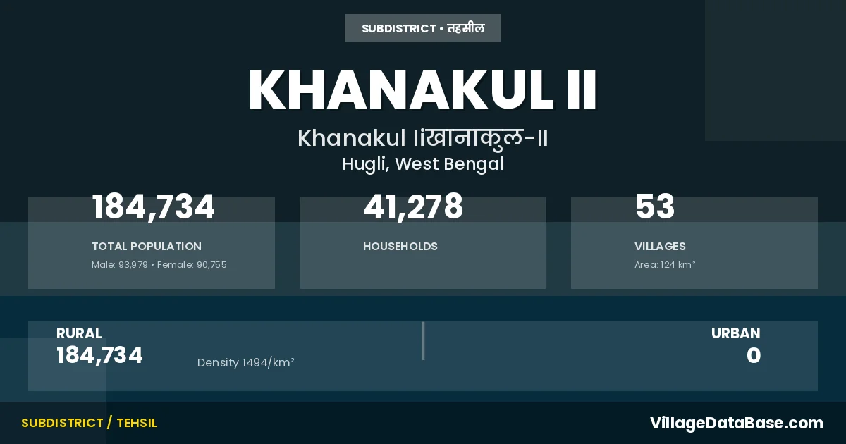
According to the 2011 census The total area of Khanakul II Subdivision is 124 km², with a population of 184734 people. The population density is 1,494 inhabitants per square kilometre, and there are approximately 41278 houses in the sub district.
Khanakul II Subdivision comprises about 53 villages. Below is a list of these villages along with information about their respective gram panchayats and the nearest town:
| # | Village Name | Gram Panchayat | Nearest Town |
|---|---|---|---|
| 1 | Baligari | Natibpur I | Arambag (40 km) |
| 2 | Balpai | Natibpur Ii | Arambagh (10 km) |
| 3 | Banhijli | Marokhana | Arambagh (38 km) |
| 4 | Bar Nandanpur | Jagatpur | Arambagh (48 km) |
| 5 | Bhairabpur | Palashpai Ii | Arambagh (10 km) |
| 6 | Chak Hayatpur | Palashpai Ii | Khanakul Ii |
| 7 | Chak Magri | Palashpai I | Arambagh (39 km) |
| 8 | Chand Kundu | Marokhana | Arambagh (38 km) |
| 9 | Chanpanagari | Palashpai I | Arambagh (36 km) |
| 10 | Chinra | Chingra | Arambag (35 km) |
| 11 | Dakshin Sudam Chak | Marokhana | Arambagh (35 km) |
| 12 | Daulat Chak | Natibpur Ii | Arambagh (10 km) |
| 13 | Dhaldanga | Marokhana | Arambagh (35 km) |
| 14 | Dhanyaghari | Dhanyagori | Arambagh (25 km) |
| 15 | Ganeshpur | Natibpur I | Arambag (39 km) |
| 16 | Ghoradaha | Dhanyagori | Aramgagh (28 km) |
| 17 | Hanua | Marokhana | Arambagh (35 km) |
| 18 | Harish Chak | Sabalsinghapur | Arambagh (10 km) |
| 19 | Hayatpur | Palashpai Ii | Arambagh (107 km) |
| 20 | Hirapur | Rajhati I | Arambagh (10 km) |
| 21 | Jagatpur | Jagatpur | Arambagh (50 km) |
| 22 | Jayrampur | Natibpur I | Arambag (37 km) |
| 23 | Joariachak | Marokhana | Arambagh (35 km) |
| 24 | Kaknan | Dhanyagori | Arambagh (25 km) |
| 25 | Kamdeb Chak | Marokhana | Arambagh (38 km) |
| 26 | Katashia | Palashpai I | Arambagh (42 km) |
| 27 | Ketedal | Chingra | Arambag (35 km) |
| 28 | Khantara | Rajhati I | Arambag (10 km) |
| 29 | Khunechak | Palashpai Ii | Arambagh (10 km) |
| 30 | Kumarhat | Rajhati I | Arambag (10 km) |
| 31 | Kushali | Rajhati I | Arambagh (10 km) |
| 32 | Madhyarang | Rajhati Ii | Arambagh (10 km) |
| 33 | Mahishnala Damkunda | Marokhana | Arambagh (38 km) |
| 34 | Mamakpur | Rajhati Ii | Arambagh (10 km) |
| 35 | Manikdwip | Marokhana | Arambagh (38 km) |
| 36 | Mansuka | Marokhana | Arambagh (37 km) |
| 37 | Marakhana | Marokhana | Arambagh (35 km) |
| 38 | Mostafapur | Palashpai I | Arambagh (33 km) |
| 39 | Nandanpur | Jagatpur | Arambagh (38 km) |
| 40 | Naopara | Natibpur I | Arambag (38 km) |
| 41 | Narendrapur | Palashpai Ii | Arambagh (10 km) |
| 42 | Natibpur | Natibpur Ii | Arambag (10 km) |
| 43 | Palashpai | Palashpai I | Arambagh (35 km) |
| 44 | Par Kalahar | Palashpai Ii | Arambagh (10 km) |
| 45 | Radhakrishnapur | Rajhati I | Arambagh (10 km) |
| 46 | Rajhati | Rajhati Ii | Arambagh (10 km) |
| 47 | Ramchandrapur | Rajhati I | Arambagh (10 km) |
| 48 | Ranjitbati | Chingra | Arambag (35 km) |
| 49 | Routkhana | Natibpur I | Arambag (35 km) |
| 50 | Sabalsinghapur | Sabalsinghapur | Arambagh (10 km) |
| 51 | Sasapota | Marokhana | Arambagh (38 km) |
| 52 | Senhat | Rajhati Ii | Arambag (10 km) |
| 53 | Tetulia | Natibpur I | Arambagh (35 km) |
The population is distributed between urban and rural areas as follows:
| Particulars | Rural | Urban | Total |
|---|---|---|---|
| Total Population | 184734 | 0 | 184734 |
| Male Population | 93979 | 0 | 93979 |
| Female Population | 90755 | 0 | 90755 | Population Density | 1494 / km² | 1,494 / km² |
The distribution of households in the Khanakul II is:
| Rural Households | Urban Households | Total Households |
|---|---|---|
| 41278 | 0 | 41278 |
Q: What is Khanakul II?
A: Khanakul II is a town and in the Hugli district of the West Bengal.
Q: What is the total area of Khanakul II Subdivision?
A: The total area of Khanakul II Subdivision is 124 km².
Q: What is the population of Khanakul II Subdivision according to the 2011 census?
A: According to the 2011 census, the population of Khanakul II Subdivision is 184734.
Q: What is the population density of Khanakul II Subdivision?
A: The population density of Khanakul II Subdivision is 1,494 inhabitants per square kilometre.
Q: How many houses are there in Khanakul II Subdivision?
A: There are approximately 41278 houses in Khanakul II Subdivision.
Q: How many villages are there in Khanakul II Subdivision?
A: There are about 53 villages in Khanakul II Subdivision.
Q: Which is the largest village by population in Khanakul II Subdivision?
A: The largest village by population in Khanakul II Subdivision is Chinra, with 12924 people.
Q: Which is the smallest village by population in Khanakul II Subdivision?
A: The smallest village by population in Khanakul II Subdivision is Chak Hayatpur, with 0 people.
Q: Which is the largest village by area in Khanakul II Subdivision?
A: The largest village by area in Khanakul II Subdivision is Chinra, with 915 km².
Q: Which is the smallest village by area in Khanakul II Subdivision?
A: The smallest village by area in Khanakul II Subdivision is Chanpanagari, with 41 km².
Q: What is the population distribution between urban and rural areas in Khanakul II Subdivision?
A: The population distribution in Khanakul II Subdivision is entirely rural, with a total rural population of 184734.
Q: What is the male population of Khanakul II Subdivision?
A: The male population of Khanakul II Subdivision is 93979.
Q: What is the female population of Khanakul II Subdivision?
A: The female population of Khanakul II Subdivision is 90755.
Q: How is the household distribution in Khanakul II Subdivision?
A: The household distribution in Khanakul II Subdivision is entirely rural, with a total of 41278 households.
Q: How many villages in Khanakul II Subdivision have a population of less than 100?
A: There are 3 villages in Khanakul II Subdivision with a population of less than 100.
Q: How many villages in Khanakul II Subdivision have a population between 100 and 499?
A: There are 6 villages in Khanakul II Subdivision with a population between 100 and 499.
Q: How many villages in Khanakul II Subdivision have a population between 500 and 999?
A: There are 5 villages in Khanakul II Subdivision with a population between 500 and 999.
Q: How many villages in Khanakul II Subdivision have a population between 1000 and 1999?
A: There are 10 villages in Khanakul II Subdivision with a population between 1000 and 1999.
Q: How many villages in Khanakul II Subdivision have a population between 2000 and 2999?
A: There is 5 village in Khanakul II Subdivision with a population between 2000 and 2999.
Q: How many villages in Khanakul II Subdivision have a population between 3000 and 3999?
A: There is 4 village in Khanakul II Subdivision with a population between 3000 and 3999.
Q: How many villages in Khanakul II Subdivision have a population between 4000 and 4999?
A: There is 2 village in Khanakul II Subdivision with a population between 4000 and 4999.
Q: How many villages in Khanakul II Subdivision have a population of 5000 and above?
A: There is 18 village in Khanakul II Subdivision with a population of 5000 and above.
| Total Population | Villages in Sub District Of Khanakul II |
|---|---|
| Less than 100 | 3 |
| 100-499 | 6 |
| 500-999 | 5 |
| 1000-1999 | 10 |
| 2000-2999 | 5 |
| 3000-3999 | 4 |
| 4000-4999 | 2 |
| 5000 And Above | 18 |