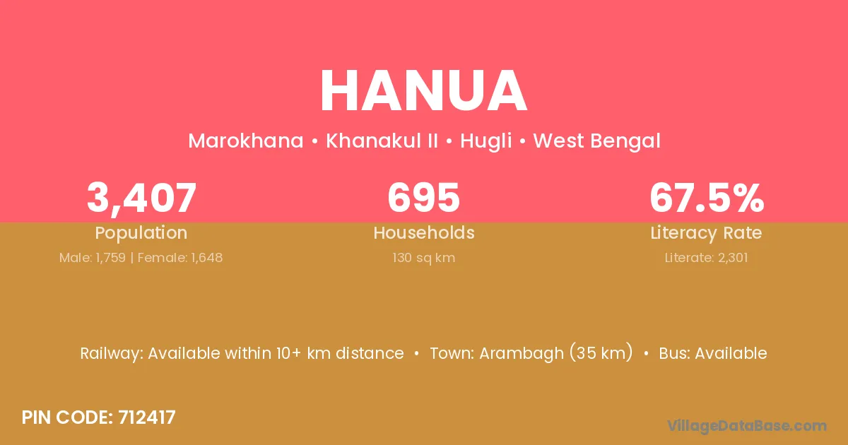
Hanua village is located in the Khanakul II Subdivision of the Hugli district in West Bengal .
Block / Subdivision → Khanakul II
District → Hugli
State → West Bengal
According to Census 2011 information, the village code of Hanua village is 712417.
Hanua village has a total population of 3,407 people, of which 1,759 are males and 1,648 are females.
The literacy rate of Hanua village is 67.54%. Male literacy stands at 75.16% and female literacy at 59.41%.
There are approximately 695 households in Hanua village.
Arambagh (35 km) is the nearest town to Hanua village for major economic activities and is located approximately 35 km away.
The population of Hanua village is distributed between literate and illiterate residents as follows:
| Particulars | Male | Female | Total |
|---|---|---|---|
| Literate | 1,322 | 979 | 2,301 |
| Illiterate | 437 | 669 | 1,106 |
| Total | 1,759 | 1,648 | 3,407 |
Source: Census 2011
| Village | District |
|---|---|
| Chak Hayatpur | Hugli |
| Dakshin Sudam Chak | Hugli |
| Harish Chak | Hugli |
| Kamdeb Chak | Hugli |
| Mamakpur | Hugli |
| Mansuka | Haora |
| Mansuka | Hugli |
| Par Kalahar | Hugli |
| Rajhati | Hugli |
| Rajhati | Hugli |
| Rajhati | Hugli |
| Rajhati | Paschim Medinipur |
| Rajhati | Purba Medinipur |
| Rajhati | Purba Medinipur |
| Rajhati | Paschim Medinipur |
| Rajhati | Purba Medinipur |
| Rajhati | Purba Medinipur |
| Sabalsinghapur | Hugli |
| Sasapota | Hugli |
| Senhat | Hugli |
No reviews yet. Be the first to review this village!
Available within 10+ km distance
Available within 10+ km distance
Available within 5 - 10 km distance