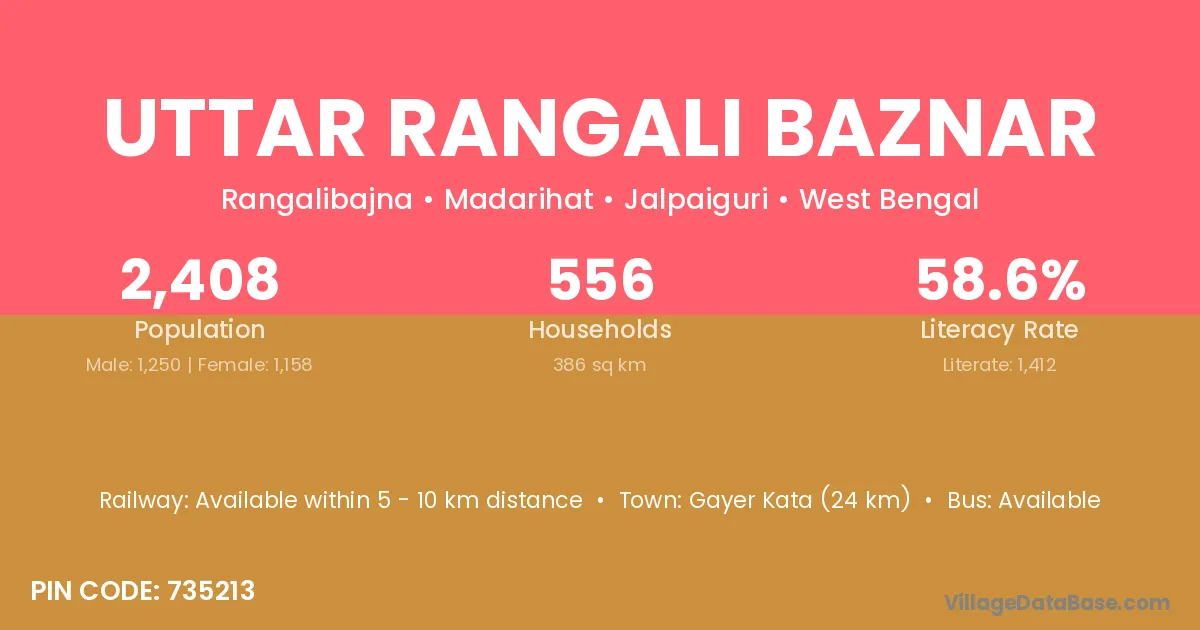
Uttar Rangali Baznar village is located in the Madarihat Subdivision of the Jalpaiguri district in West Bengal .
Block / Subdivision → Madarihat
District → Jalpaiguri
State → West Bengal
According to Census 2011 information, the village code of Uttar Rangali Baznar village is 735213.
Uttar Rangali Baznar village has a total population of 2,408 people, of which 1,250 are males and 1,158 are females.
The literacy rate of Uttar Rangali Baznar village is 58.64%. Male literacy stands at 62.88% and female literacy at 54.06%.
There are approximately 556 households in Uttar Rangali Baznar village.
Gayer Kata (24 km) is the nearest town to Uttar Rangali Baznar village for major economic activities and is located approximately 24 km away.
The population of Uttar Rangali Baznar village is distributed between literate and illiterate residents as follows:
| Particulars | Male | Female | Total |
|---|---|---|---|
| Literate | 786 | 626 | 1,412 |
| Illiterate | 464 | 532 | 996 |
| Total | 1,250 | 1,158 | 2,408 |
Source: Census 2011
| Village | District |
|---|---|
| Holapara Forest | Jalpaiguri |
| Islamabad | Cachar |
| Islamabad | Imphal East |
| Islamabad | Bahraich |
| Islamabad | Bareilly |
| Islamabad | Bijnor |
| Islamabad | Deoria |
| Islamabad | Ghazipur |
| Islamabad | Kheri |
| Islamabad | Muzaffarnagar |
| Islamabad | Jalpaiguri |
| Khairbari Forest | Jalpaiguri |
| Madhya Chhekamari | Jalpaiguri |
| Madhya Khairbari | Jalpaiguri |
| Madhya Madarihat | Jalpaiguri |
| Mujnai Tea Garden | Jalpaiguri |
| Pashchim Khayerbari | Jalpaiguri |
| Purba Khairbari | Jalpaiguri |
| Uttar Chhekamari | Jalpaiguri |
| Uttar Khairbari | Jalpaiguri |
No reviews yet. Be the first to review this village!
Available within 5 - 10 km distance
Available within 5 - 10 km distance
Available within 5 - 10 km distance