Welcome Back

Forgot password?
Don't have an account?
🏘️ Menu
Kurnool District 0.0 / 5 (0)

Munagala Village Detailed Information

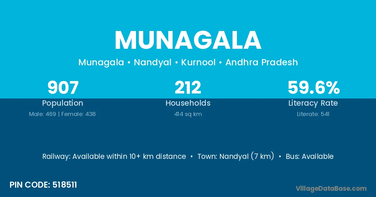
Munagala village is located in the Nandyal Mandal of the Kurnool district in Andhra Pradesh .

About Munagala Village

Block / Mandal → Nandyal

District → Kurnool

State → Andhra Pradesh

According to Census 2011 information, the village code of Munagala village is 518511.

Munagala village has a total population of 907 people, of which 469 are males and 438 are females.

The literacy rate of Munagala village is 59.65%. Male literacy stands at 74.20% and female literacy at 44.06%.

There are approximately 212 households in Munagala village.

Nandyal (7 km) is the nearest town to Munagala village for major economic activities and is located approximately 7 km away.

Population of Munagala Village

The population of Munagala village is distributed between literate and illiterate residents as follows:

Population distribution of Munagala village by literacy and gender
Particulars Male Female Total
Literate 348 193 541
Illiterate 121 245 366
Total 469 438 907

Source: Census 2011

Nearby Villages

List of nearby villages around Munagala village
Village District
Bheemavaram Chittoor
Bheemavaram East Godavari
Bheemavaram Kurnool
Bheemavaram Prakasam
Bheemavaram Sri Potti Sriramulu Nellore
Bheemavaram Visakhapatnam
Bheemavaram Vizianagaram
Bheemavaram Khammam
Bheemavaram Khammam
Bheemavaram Khammam
Bheemavaram Mahbubnagar
Bheemavaram Nalgonda
Billalapuram Kurnool
Kottala Kurnool
Nandyal Kurnool
Nandyal Bijapur
Polur Kurnool
Polur Malkangiri
Polur Vellore
Pulimaddi Kurnool
Rayamalpuram Kurnool
Udumalpuram Kurnool

Frequently Asked Questions

Munagala village is located in the Nandyal Mandal of the Kurnool district in Andhra Pradesh.
The total population is 907 people.
469 males and 438 females.
The literacy rate is 59.65%.
Male literacy rate is 74.20%, and female literacy rate is 44.06%.
There are approximately 212 houses in Munagala village.
Nandyal (7 km) is the nearest town, located approximately 7 km away.

Reviews and Ratings

0.0 / 5 (0 reviews)

Reviews

No reviews yet. Be the first to review this village!

Munagala Village Statistics

Population
907
Area
414 km²
Households
212
Nearest Town :
Nandyal (7 km)

Quick Information

State / UT : Andhra Pradesh
Pincode : 518511
Total Area : 414 km²
Population : 907
Households : 212
Gram Panchayat : Munagala
Nearest Town : Nandyal (7 km)

Connectivity of Munagala

🚂 Railway Station

Available within 10+ km distance

🚌 Public Bus Service

Available within 5 - 10 km distance

🚌 Private Bus Service

Available within 5 - 10 km distance

Need Help?

Contact local tourism office for assistance