Welcome Back

Forgot password?
Don't have an account?
🏘️ Menu
Kurnool District 0.0 / 5 (0)

Mettupalle Village Detailed Information

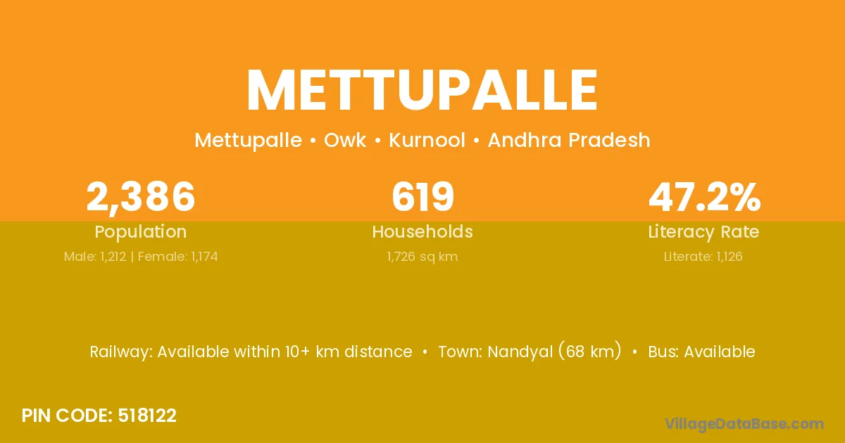
Mettupalle village is located in the Owk Mandal of the Kurnool district in Andhra Pradesh .

Mettupalle

About Mettupalle Village

Block / Mandal → Owk

District → Kurnool

State → Andhra Pradesh

According to Census 2011 information, the village code of Mettupalle village is 518122.

Mettupalle village has a total population of 2,386 people, of which 1,212 are males and 1,174 are females.

The literacy rate of Mettupalle village is 47.19%. Male literacy stands at 56.77% and female literacy at 37.31%.

There are approximately 619 households in Mettupalle village.

Nandyal (68 km) is the nearest town to Mettupalle village for major economic activities and is located approximately 68 km away.

Population of Mettupalle Village

The population of Mettupalle village is distributed between literate and illiterate residents as follows:

Population distribution of Mettupalle village by literacy and gender
Particulars Male Female Total
Literate 688 438 1,126
Illiterate 524 736 1,260
Total 1,212 1,174 2,386

Source: Census 2011

Nearby Villages

List of nearby villages around Mettupalle village
Village District
Annavaram East Godavari
Annavaram Guntur
Annavaram Guntur
Annavaram Guntur
Annavaram Krishna
Annavaram Krishna
Annavaram Krishna
Annavaram Kurnool
Annavaram Sri Potti Sriramulu Nellore
Annavaram Srikakulam
Annavaram Visakhapatnam
Annavaram West Godavari
Annavaram Khammam
Annavaram Khammam
Chennampalle Anantapur
Chennampalle Kurnool
Chennampalle Mahbubnagar
Gundla Singavaram Kurnool
Nichenametla Kurnool
Ramavaram East Godavari
Ramavaram Krishna
Ramavaram Kurnool
Ramavaram Visakhapatnam
Ramavaram Vizianagaram
Ramavaram Karimnagar
Ramavaram Khammam
Ramavaram Khammam
Ramavaram Khammam
Ramavaram Nalgonda
Ramavaram Warangal
Ramavaram Warangal
Ramavaram Warangal
Ramavaram Warangal
Sivavaram Kurnool
Vajragiri Kurnool
Vemulapadu Anantapur
Vemulapadu Kurnool

Frequently Asked Questions

Mettupalle village is located in the Owk Mandal of the Kurnool district in Andhra Pradesh.
The total population is 2,386 people.
1,212 males and 1,174 females.
The literacy rate is 47.19%.
Male literacy rate is 56.77%, and female literacy rate is 37.31%.
There are approximately 619 houses in Mettupalle village.
Nandyal (68 km) is the nearest town, located approximately 68 km away.

Reviews and Ratings

0.0 / 5 (0 reviews)

Reviews

No reviews yet. Be the first to review this village!

Mettupalle Village Statistics

Population
2386
Area
1726 km²
Households
619
Nearest Town :
Nandyal (68 km)

Quick Information

State / UT : Andhra Pradesh
Pincode : 518122
Total Area : 1726 km²
Population : 2386
Households : 619
Gram Panchayat : Mettupalle
Nearest Town : Nandyal (68 km)

Connectivity of Mettupalle

🚂 Railway Station

Available within 10+ km distance

🚌 Public Bus Service

Available within village

🚌 Private Bus Service

Available within <5 km distance

Need Help?