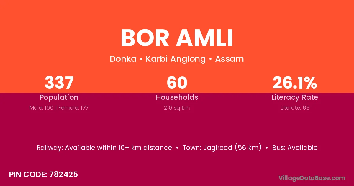
Bor Amli village is located in the Donka Subdivision of the Karbi Anglong district in Assam .
Block / Subdivision → Donka
District → Karbi Anglong
State → Assam
According to Census 2011 information, the village code of Bor Amli village is 782425.
Bor Amli village has a total population of 337 people, of which 160 are males and 177 are females.
The literacy rate of Bor Amli village is 26.11%. Male literacy stands at 28.13% and female literacy at 24.29%.
There are approximately 60 households in Bor Amli village.
Jagiroad (56 km) is the nearest town to Bor Amli village for major economic activities and is located approximately 56 km away.
The population of Bor Amli village is distributed between literate and illiterate residents as follows:
| Particulars | Male | Female | Total |
|---|---|---|---|
| Literate | 45 | 43 | 88 |
| Illiterate | 115 | 134 | 249 |
| Total | 160 | 177 | 337 |
Source: Census 2011
| Village | District |
|---|---|
| Ben Terang | Karbi Anglong |
| Chupi Kelok | Karbi Anglong |
| Hatigarh | Dhemaji |
| Hatigarh | Karbi Anglong |
| Hatigarh | Nagaon |
| Hatigarh | Nagaon |
| Hatigarh | Udalguri |
| Karbi Lalung | Karbi Anglong |
| Keraidong | Karbi Anglong |
| Kong Kat | Karbi Anglong |
| Langpok Kang | Karbi Anglong |
| Mortel | Karbi Anglong |
| Pipar Gaon | Karbi Anglong |
| Pipar Gaon | Farrukhabad |
| Pipar Gaon | Sant Ravidas Nagar |
| Radhala | Karbi Anglong |
| Saru Amli | Karbi Anglong |
No reviews yet. Be the first to review this village!
Available within 10+ km distance
Available within 10+ km distance
Available within village