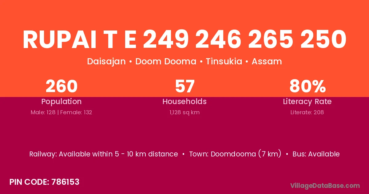
Rupai T E 249 246 265 250 village is located in the Doom Dooma Subdivision of the Tinsukia district in Assam .
Block / Subdivision → Doom Dooma
District → Tinsukia
State → Assam
According to Census 2011 information, the village code of Rupai T E 249 246 265 250 village is 786153.
Rupai T E 249 246 265 250 village has a total population of 260 people, of which 128 are males and 132 are females.
The literacy rate of Rupai T E 249 246 265 250 village is 80.00%. Male literacy stands at 83.59% and female literacy at 76.52%.
There are approximately 57 households in Rupai T E 249 246 265 250 village.
Doomdooma (7 km) is the nearest town to Rupai T E 249 246 265 250 village for major economic activities and is located approximately 7 km away.
The population of Rupai T E 249 246 265 250 village is distributed between literate and illiterate residents as follows:
| Particulars | Male | Female | Total |
|---|---|---|---|
| Literate | 107 | 101 | 208 |
| Illiterate | 21 | 31 | 52 |
| Total | 128 | 132 | 260 |
Source: Census 2011
| Village | District |
|---|---|
| Bissakopi Gaon | Tinsukia |
| Bissakupi T E 72 Wl | Tinsukia |
| Bor Rupai Gaon | Tinsukia |
| Daimukhiya Gaon | Tinsukia |
| Daimukhiya T E 25 26 Wl | Tinsukia |
| Diamuli T E 269 Nlr | Tinsukia |
| Ouguri Gaon | Tinsukia |
| Rupai | Srikakulam |
| Rupai | Karbi Anglong |
| Rupai | Tinsukia |
| Rupai | Nawada |
| Rupai | Deoria |
| Rupai | Paschim Medinipur |
| Rupai | Paschim Medinipur |
| Rupai T E 232 230 Nlr | Tinsukia |
| Rupai T E 233 231 Nlr | Tinsukia |
| Rupai T E 246 244 Nlr | Tinsukia |
No reviews yet. Be the first to review this village!
Available within 5 - 10 km distance
Available within 5 - 10 km distance
Available within 5 - 10 km distance