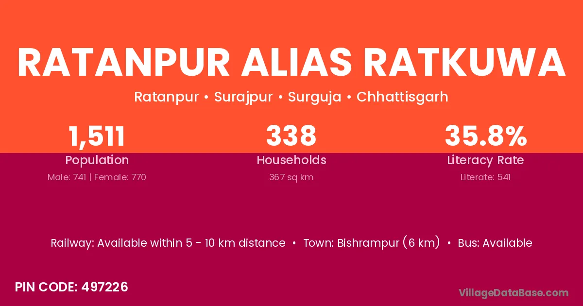
Ratanpur Alias Ratkuwa village is located in the Surajpur Tehsil of the Surguja district in Chhattisgarh .
Block / Tehsil → Surajpur
District → Surguja
State → Chhattisgarh
According to Census 2011 information, the village code of Ratanpur Alias Ratkuwa village is 497226.
Ratanpur Alias Ratkuwa village has a total population of 1,511 people, of which 741 are males and 770 are females.
The literacy rate of Ratanpur Alias Ratkuwa village is 35.80%. Male literacy stands at 42.91% and female literacy at 28.96%.
There are approximately 338 households in Ratanpur Alias Ratkuwa village.
Bishrampur (6 km) is the nearest town to Ratanpur Alias Ratkuwa village for major economic activities and is located approximately 6 km away.
The population of Ratanpur Alias Ratkuwa village is distributed between literate and illiterate residents as follows:
| Particulars | Male | Female | Total |
|---|---|---|---|
| Literate | 318 | 223 | 541 |
| Illiterate | 423 | 547 | 970 |
| Total | 741 | 770 | 1,511 |
Source: Census 2011
| Village | District |
|---|---|
| Arjun Nagar Alias Amakhoh | Surguja |
| Gorakhnathpur | Surguja |
| Harratikra | Surguja |
| Jainagar | Araria |
| Jainagar | Gaya |
| Jainagar | Madhubani |
| Jainagar | Purba Champaran |
| Jainagar | Surguja |
| Jainagar | Dhanbad |
| Jainagar | Giridih |
| Jainagar | Kodarma |
| Jainagar | Rajgarh |
| Jainagar | Latur |
| Jainagar | Nandurbar |
| Jainagar | Baleshwar |
| Jainagar | Patiala |
| Jainagar | Bhilwara |
| Jainagar | Bundi |
| Jainagar | Chittaurgarh |
| Jainagar | Rajsamand |
| Jainagar | Tonk |
| Jainagar | Udham Singh Nagar |
| Jainagar | Murshidabad |
| Jainagar | Murshidabad |
| Jamdei | Surguja |
| Kandrai | Jashpur |
| Kandrai | Surguja |
| Kandrai | Gorakhpur |
| Koreya | Goalpara |
| Koreya | Gopalganj |
| Koreya | Surguja |
| Kunjnagar | Surguja |
| Pendarkhi | Surguja |
| Pendarkhi | Surguja |
| Rajapur Alias Rakra | Surguja |
| Satpata | Surguja |
No reviews yet. Be the first to review this village!
Available within 5 - 10 km distance
Available
Available within 5 - 10 km distance