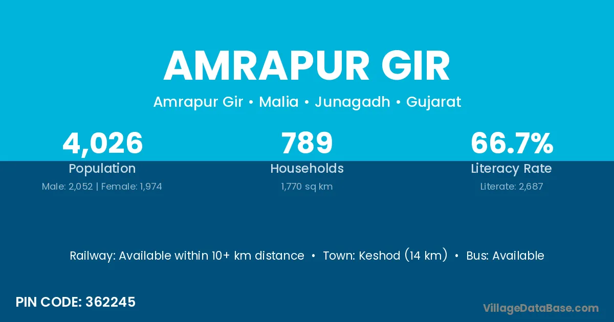
Amrapur Gir village is located in the Malia Taluka of the Junagadh district in Gujarat .
Block / Taluka → Malia
District → Junagadh
State → Gujarat
According to Census 2011 information, the village code of Amrapur Gir village is 362245.
Amrapur Gir village has a total population of 4,026 people, of which 2,052 are males and 1,974 are females.
The literacy rate of Amrapur Gir village is 66.74%. Male literacy stands at 74.51% and female literacy at 58.66%.
There are approximately 789 households in Amrapur Gir village.
Keshod (14 km) is the nearest town to Amrapur Gir village for major economic activities and is located approximately 14 km away.
The population of Amrapur Gir village is distributed between literate and illiterate residents as follows:
| Particulars | Male | Female | Total |
|---|---|---|---|
| Literate | 1,529 | 1,158 | 2,687 |
| Illiterate | 523 | 816 | 1,339 |
| Total | 2,052 | 1,974 | 4,026 |
Source: Census 2011
| Village | District |
|---|---|
| Akala | Amreli |
| Akala | Junagadh |
| Akala | Rajkot |
| Akala | Surendranagar |
| Akala | Mysore |
| Akala | Shahdol |
| Akala | Kapurthala |
| Akala | Basti |
| Ambalgadh | Junagadh |
| Bhankharvad | Junagadh |
| Bodi | Bhavnagar |
| Bodi | Jamnagar |
| Bodi | Junagadh |
| Bodi | Sabar Kantha |
| Bodi | Betul |
| Bodi | Chhatarpur |
| Bodi | Chhindwara |
| Bodi | Hoshangabad |
| Bodi | Jabalpur |
| Bodi | Sehore |
| Bodi | Singrauli |
| Galodar | Junagadh |
| Kalimbhda | Junagadh |
| Malia | Lakhisarai |
| Malia | Junagadh |
| Malia | Chatra |
| Malia | Gurdaspur |
| Malia | Tarn Taran |
| Malia | Haora |
| Malia | Hugli |
| Matarvaniya | Junagadh |
| Tarsingda | Junagadh |
| Vadala | Junagadh |
| Vadala | Junagadh |
| Vadala | Junagadh |
| Vadala | Kachchh |
| Vadala | Kheda |
| Vadala | Porbandar |
| Vadala | Porbandar |
| Vadala | Surendranagar |
| Virdi | Ahmadabad |
| Virdi | Amreli |
| Virdi | Bhavnagar |
| Virdi | Bhavnagar |
| Virdi | Bhavnagar |
| Virdi | Junagadh |
| Virdi | Sindhudurg |
No reviews yet. Be the first to review this village!
Available within 10+ km distance
Available within village
Available within 10+ km distance