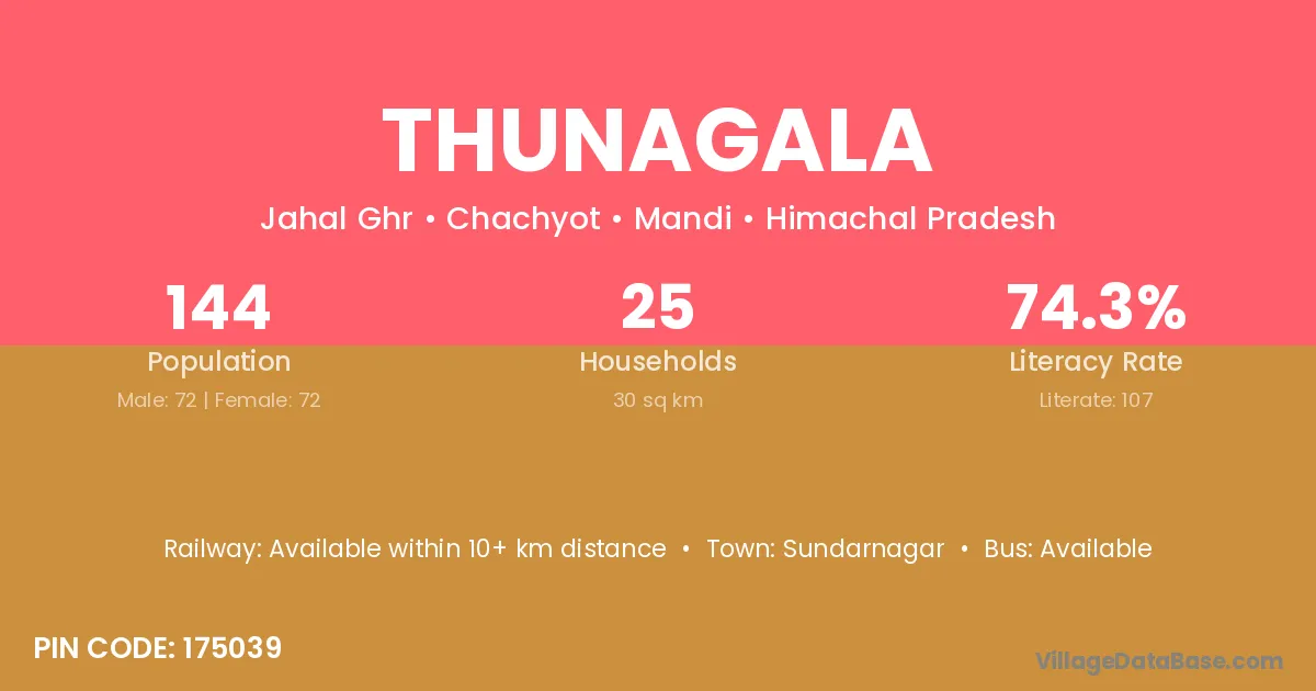
Thunagala village is located in the Chachyot Tehsil of the Mandi district in Himachal Pradesh .
Block / Tehsil → Chachyot
District → Mandi
State → Himachal Pradesh
According to Census 2011 information, the village code of Thunagala village is 175039.
Thunagala village has a total population of 144 people, of which 72 are males and 72 are females.
The literacy rate of Thunagala village is 74.31%. Male literacy stands at 83.33% and female literacy at 65.28%.
There are approximately 25 households in Thunagala village.
Sundarnagar is the nearest town to Thunagala village for major economic activities
The population of Thunagala village is distributed between literate and illiterate residents as follows:
| Particulars | Male | Female | Total |
|---|---|---|---|
| Literate | 60 | 47 | 107 |
| Illiterate | 12 | 25 | 37 |
| Total | 72 | 72 | 144 |
Source: Census 2011
| Village | District |
|---|---|
| Bhaura | Saharsa |
| Bhaura | Mandi |
| Bhaura | Mandi |
| Bhaura | Guna |
| Bhaura | Shahid Bhagat Singh Nagar |
| Bhaura | Barmer |
| Bhaura | Bareilly |
| Bhaura | Jaunpur |
| Bhaura | Kanpur Dehat |
| Bukhras | Mandi |
| Chawali | Mandi |
| Chawali | Nagaur |
| Chawali | Bulandshahr |
| D P F Chulinal | Mandi |
| D P F Tokharnal | Mandi |
| Ghalot | Hamirpur |
| Ghalot | Kangra |
| Ghalot | Mandi |
| Ghalot | Solan |
| Ghusnu | Mandi |
| Kutla | Mandi |
| Mathiana | Mandi |
| Rani | East Siang |
| Rani | Kamrup |
| Rani | Araria |
| Rani | Banka |
| Rani | Begusarai |
| Rani | Kishanganj |
| Rani | Purnia |
| Rani | Mandi |
| Rani | Udaipur |
| Rani | South Tripura |
| Rani | Dehradun |
| Tokhar | Mandi |
No reviews yet. Be the first to review this village!
Available within 10+ km distance
Available within <5 km distance
Available within <5 km distance