Welcome Back

Forgot password?
Don't have an account?
🏘️ Menu
Chhindwara District 0.0 / 5 (0)

Umarghod Village Detailed Information

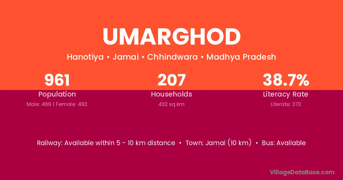
Umarghod village is located in the Jamai Tehsil of the Chhindwara district in Madhya Pradesh .

About Umarghod Village

Block / Tehsil → Jamai

District → Chhindwara

State → Madhya Pradesh

Umarghod village has a total population of 961 people, of which 469 are males and 492 are females.

The literacy rate of Umarghod village is 38.71%. Male literacy stands at 46.91% and female literacy at 30.89%.

There are approximately 207 households in Umarghod village.

Jamai (10 km) is the nearest town to Umarghod village for major economic activities and is located approximately 10 km away.

Population of Umarghod Village

The population of Umarghod village is distributed between literate and illiterate residents as follows:

Population distribution of Umarghod village by literacy and gender
Particulars Male Female Total
Literate 220 152 372
Illiterate 249 340 589
Total 469 492 961

Source: Census 2011

Nearby Villages

List of nearby villages around Umarghod village
Village District
Abriya Chhindwara
Bhimsani Khurd Chhindwara
Bhimsani Ryt Chhindwara
Budhwara Sitamarhi
Budhwara Bilaspur
Budhwara Bilaspur
Budhwara Durg
Budhwara Kabeerdham
Budhwara Kabeerdham
Budhwara Chhindwara
Budhwara Narsimhapur
Budhwara Seoni
Budhwara Ajmer
Budhwara Jhalawar
Budhwara Pali
Budhwara Mahoba
Dhadra Chhindwara
Dhadra Meerut
Dodasemar Chhindwara
Gujarghat Chhindwara
Hanotiya Betul
Hanotiya Chhindwara
Hanotiya Baran
Hanotiya Baran
Hanotiya Baran
Hanotiya Kota
Hanotiya Tonk
Hanotiya Tonk
Hanotiya Lalitpur
Khairmandal Chhindwara
Panara Barpeta
Panara Kamrup
Panara Chhindwara
Panara Mahoba
Panara Puruliya
Panara Puruliya
Upli Karnal
Upli Chhindwara
Upli Aurangabad
Upli Bid
Upli Sangrur

Frequently Asked Questions

Umarghod village is located in the Jamai Tehsil of the Chhindwara district in Madhya Pradesh.
The total population is 961 people.
469 males and 492 females.
The literacy rate is 38.71%.
Male literacy rate is 46.91%, and female literacy rate is 30.89%.
There are approximately 207 houses in Umarghod village.
Jamai (10 km) is the nearest town, located approximately 10 km away.

Reviews and Ratings

0.0 / 5 (0 reviews)

Reviews

No reviews yet. Be the first to review this village!

Umarghod Village Statistics

Population
961
Area
432 km²
Households
207
Nearest Town :
Jamai (10 km)

Quick Information

State / UT : Madhya Pradesh
Total Area : 432 km²
Population : 961
Households : 207
Gram Panchayat : Hanotiya
Nearest Town : Jamai (10 km)

Connectivity of Umarghod

🚂 Railway Station

Available within 5 - 10 km distance

🚌 Public Bus Service

Available within 5 - 10 km distance

🚌 Private Bus Service

Available within 5 - 10 km distance

Need Help?

Contact local tourism office for assistance