Welcome Back

Forgot password?
Don't have an account?
🏘️ Menu
Nanded District 0.0 / 5 (0)

Karkala Village Detailed Information

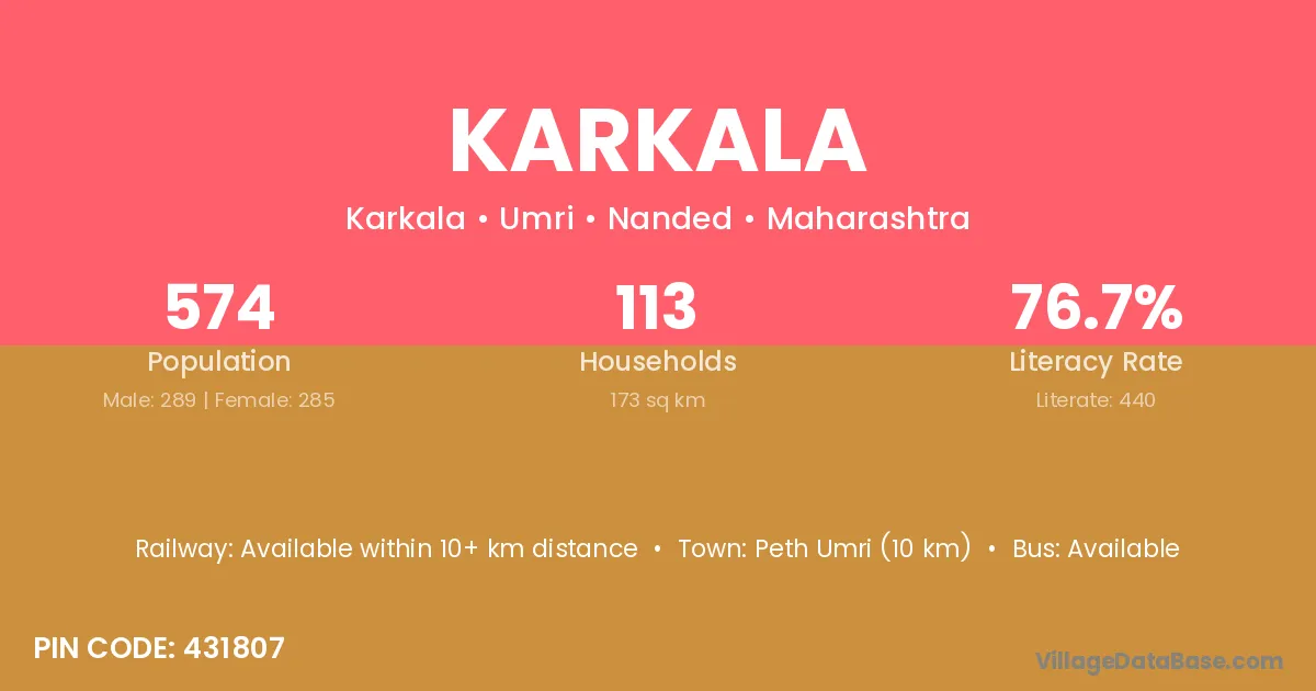
Karkala village is located in the Umri Tehsil of the Nanded district in Maharashtra .

About Karkala Village

Block / Tehsil → Umri

District → Nanded

State → Maharashtra

According to Census 2011 information, the village code of Karkala village is 431807.

Karkala village has a total population of 574 people, of which 289 are males and 285 are females.

The literacy rate of Karkala village is 76.66%. Male literacy stands at 83.04% and female literacy at 70.18%.

There are approximately 113 households in Karkala village.

Peth Umri (10 km) is the nearest town to Karkala village for major economic activities and is located approximately 10 km away.

Population of Karkala Village

The population of Karkala village is distributed between literate and illiterate residents as follows:

Population distribution of Karkala village by literacy and gender
Particulars Male Female Total
Literate 240 200 440
Illiterate 49 85 134
Total 289 285 574

Source: Census 2011

Nearby Villages

List of nearby villages around Karkala village
Village District
Hatni Madhubani
Kaudgaon Bidar
Bijegaon Mandla
Bijegaon Mandla
Bijegaon Mandla
Kaudgaon Ahmadnagar
Singnapur Ahmadnagar
Kaudgaon Ahmadnagar
Kaudgaon Ahmadnagar
Golegaon Ahmadnagar
Golegaon Akola
Golegaon Amravati
Golegaon Amravati
Golegaon Aurangabad
Golegaon Aurangabad
Kaudgaon Aurangabad
Golegaon Bid
Kaudgaon Bid
Kaudgaon Bid
Hatni Buldana
Golegaon Buldana
Golegaon Hingoli
Kaudgaon Hingoli
Kaudgaon Jalna
Golegaon Jalna
Kaudgaon Latur
Golegaon Nanded
Hatni Nanded
Kaudgaon Nanded
Golegaon Nanded
Bijegaon Nanded
Borjuni Nanded
Endala Nanded
Golegaon Nanded
Hassa Nanded
Hatni Nanded
Kaudgaon Nanded
Kawalguda Bk Nanded
Kawalguda Kh Nanded
Singnapur Nanded
Waghalwada Nanded
Golegaon Nashik
Golegaon Osmanabad
Kaudgaon Osmanabad
Golegaon Osmanabad
Kaudgaon Parbhani
Singnapur Parbhani
Golegaon Parbhani
Golegaon Pune
Golegaon Pune
Golegaon Pune
Singnapur Sangli
Golegaon Satara
Hatni Yavatmal
Kaudgaon Yavatmal
Hatni Hugli

Frequently Asked Questions

Karkala village is located in the Umri Tehsil of the Nanded district in Maharashtra.
The total population is 574 people.
289 males and 285 females.
The literacy rate is 76.66%.
Male literacy rate is 83.04%, and female literacy rate is 70.18%.
There are approximately 113 houses in Karkala village.
Peth Umri (10 km) is the nearest town, located approximately 10 km away.

Reviews and Ratings

0.0 / 5 (0 reviews)

Reviews

No reviews yet. Be the first to review this village!

Karkala Village Statistics

Population
574
Area
173 km²
Households
113
Nearest Town :
Peth Umri (10 km)

Quick Information

State / UT : Maharashtra
Pincode : 431807
Total Area : 173 km²
Population : 574
Households : 113
Gram Panchayat : Karkala
Nearest Town : Peth Umri (10 km)

Connectivity of Karkala

🚂 Railway Station

Available within 10+ km distance

🚌 Public Bus Service

Available within village

🚌 Private Bus Service

Available within 10+ km distance

Need Help?

Contact local tourism office for assistance