Welcome Back

Forgot password?
Don't have an account?
🏘️ Menu
Osmanabad District 0.0 / 5 (0)

Andur Village Detailed Information

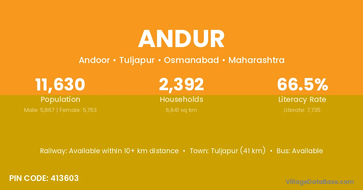
Andur village is located in the Tuljapur Tehsil of the Osmanabad district in Maharashtra .

About Andur Village

Block / Tehsil → Tuljapur

District → Osmanabad

State → Maharashtra

According to Census 2011 information, the village code of Andur village is 413603.

Andur village has a total population of 11,630 people, of which 5,867 are males and 5,763 are females.

The literacy rate of Andur village is 66.51%. Male literacy stands at 72.52% and female literacy at 60.39%.

There are approximately 2,392 households in Andur village.

Tuljapur (41 km) is the nearest town to Andur village for major economic activities and is located approximately 41 km away.

Population of Andur Village

The population of Andur village is distributed between literate and illiterate residents as follows:

Population distribution of Andur village by literacy and gender
Particulars Male Female Total
Literate 4,255 3,480 7,735
Illiterate 1,612 2,283 3,895
Total 5,867 5,763 11,630

Source: Census 2011

Nearby Villages

List of nearby villages around Andur village
Village District
Aliyabad Bijapur
Aliyabad Akola
Aliyabad Amravati
Aliyabad Aurangabad
Aliyabad Nashik
Aliyabad Osmanabad
Aliyabad Tonk
Aliyabad Warangal
Aliyabad Fatehpur
Chikundra Osmanabad
Chivari Osmanabad
Haglur Osmanabad
Haglur Solapur
Khudawadi Osmanabad
Manewadi Ahmadnagar
Manewadi Ahmadnagar
Manewadi Bid
Manewadi Kolhapur
Manewadi Kolhapur
Manewadi Osmanabad
Manewadi Sangli
Manewadi Sangli
Manewadi Satara
Manewadi Satara
Manewadi Solapur
Naldurg Osmanabad
Ramtirth Surguja
Ramtirth Jalna
Ramtirth Latur
Ramtirth Nanded
Ramtirth Nanded
Ramtirth Osmanabad
Ramtirth Solapur
Ramtirth Washim
Ramtirth Yavatmal
Umarga Latur
Umarga Osmanabad
Umarga Osmanabad
Wagdari Ahmadnagar
Wagdari Latur
Wagdari Osmanabad
Wagdari Osmanabad
Wagdari Parbhani
Wagdari Solapur
Wagdari Washim
Yedola Osmanabad

Frequently Asked Questions

Andur village is located in the Tuljapur Tehsil of the Osmanabad district in Maharashtra.
The total population is 11,630 people.
5,867 males and 5,763 females.
The literacy rate is 66.51%.
Male literacy rate is 72.52%, and female literacy rate is 60.39%.
There are approximately 2,392 houses in Andur village.
Tuljapur (41 km) is the nearest town, located approximately 41 km away.

Reviews and Ratings

0.0 / 5 (0 reviews)

Reviews

No reviews yet. Be the first to review this village!

Andur Village Statistics

Population
11630
Area
6641 km²
Households
2392
Nearest Town :
Tuljapur (41 km)

Quick Information

State / UT : Maharashtra
Pincode : 413603
Total Area : 6641 km²
Population : 11630
Households : 2392
Gram Panchayat : Andoor
Nearest Town : Tuljapur (41 km)

Connectivity of Andur

🚂 Railway Station

Available within 10+ km distance

🚌 Public Bus Service

Available within village

🚌 Private Bus Service

Available within village

Need Help?

Contact local tourism office for assistance