Welcome Back

Forgot password?
Don't have an account?
🏘️ Menu
Raigarh District 0.0 / 5 (0)

Muthavali Village Detailed Information

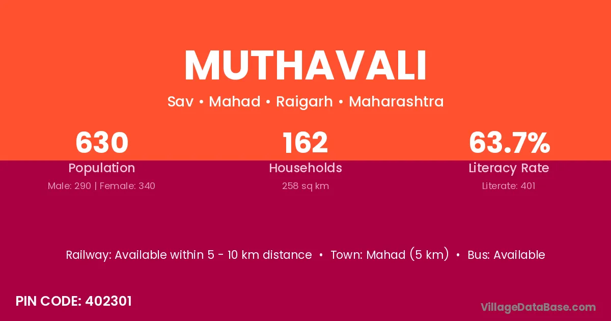
Muthavali village is located in the Mahad Tehsil of the Raigarh district in Maharashtra .

About Muthavali Village

Block / Tehsil → Mahad

District → Raigarh

State → Maharashtra

According to Census 2011 information, the village code of Muthavali village is 402301.

Muthavali village has a total population of 630 people, of which 290 are males and 340 are females.

The literacy rate of Muthavali village is 63.65%. Male literacy stands at 75.52% and female literacy at 53.53%.

There are approximately 162 households in Muthavali village.

Mahad (5 km) is the nearest town to Muthavali village for major economic activities and is located approximately 5 km away.

Population of Muthavali Village

The population of Muthavali village is distributed between literate and illiterate residents as follows:

Population distribution of Muthavali village by literacy and gender
Particulars Male Female Total
Literate 219 182 401
Illiterate 71 158 229
Total 290 340 630

Source: Census 2011

Nearby Villages

List of nearby villages around Muthavali village
Village District
Chandhave Kh Raigarh
Chochinde Raigarh
Chochinde Kond Raigarh
Dadali Raigarh
Kemburli Raigarh
Kinjalghar Raigarh
Kinjalghar Ratnagiri
Kol Vadodara
Kol Solan
Kol Satna
Kol Raigarh
Kol Azamgarh
Kol Azamgarh
Kol Gorakhpur
Kol Meerut
Kol Rae Bareli
Kotheri Raigarh
Sav Raigarh
Shirgaon Belgaum
Shirgaon Kolhapur
Shirgaon Kolhapur
Shirgaon Kolhapur
Shirgaon Pune
Shirgaon Pune
Shirgaon Pune
Shirgaon Raigarh
Shirgaon Raigarh
Shirgaon Ratnagiri
Shirgaon Ratnagiri
Shirgaon Ratnagiri
Shirgaon Ratnagiri
Shirgaon Sangli
Shirgaon Sangli
Shirgaon Satara
Shirgaon Satara
Shirgaon Sindhudurg
Shirgaon Solapur
Shirgaon Thane
Shirgaon Thane
Shirgaon Thane
Shirgaon Thane
Wadwali Aurangabad
Wadwali Raigarh

Frequently Asked Questions

Muthavali village is located in the Mahad Tehsil of the Raigarh district in Maharashtra.
The total population is 630 people.
290 males and 340 females.
The literacy rate is 63.65%.
Male literacy rate is 75.52%, and female literacy rate is 53.53%.
There are approximately 162 houses in Muthavali village.
Mahad (5 km) is the nearest town, located approximately 5 km away.

Reviews and Ratings

0.0 / 5 (0 reviews)

Reviews

No reviews yet. Be the first to review this village!

Muthavali Village Statistics

Population
630
Area
258 km²
Households
162
Nearest Town :
Mahad (5 km)

Quick Information

State / UT : Maharashtra
Pincode : 402301
Total Area : 258 km²
Population : 630
Households : 162
Gram Panchayat : Sav
Nearest Town : Mahad (5 km)

Connectivity of Muthavali

🚂 Railway Station

Available within 5 - 10 km distance

🚌 Public Bus Service

Available within village

🚌 Private Bus Service

Available within <5 km distance

Need Help?

Contact local tourism office for assistance