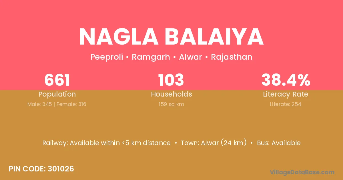
Nagla Balaiya village is located in the Ramgarh Tehsil of the Alwar district in Rajasthan .
Block / Tehsil → Ramgarh
District → Alwar
State → Rajasthan
According to Census 2011 information, the village code of Nagla Balaiya village is 301026.
Nagla Balaiya village has a total population of 661 people, of which 345 are males and 316 are females.
The literacy rate of Nagla Balaiya village is 38.43%. Male literacy stands at 52.46% and female literacy at 23.10%.
There are approximately 103 households in Nagla Balaiya village.
Alwar (24 km) is the nearest town to Nagla Balaiya village for major economic activities and is located approximately 24 km away.
The population of Nagla Balaiya village is distributed between literate and illiterate residents as follows:
| Particulars | Male | Female | Total |
|---|---|---|---|
| Literate | 181 | 73 | 254 |
| Illiterate | 164 | 243 | 407 |
| Total | 345 | 316 | 661 |
Source: Census 2011
| Village | District |
|---|---|
| Baghori | Deoghar |
| Baghori | Alwar |
| Baghori | Udham Singh Nagar |
| Bardod | Alwar |
| Bardod | Alwar |
| Bardod | Bhilwara |
| Bera Was | Alwar |
| Bere | Latehar |
| Bere | Thane |
| Bere | Alwar |
| Chandigarh | Baleshwar |
| Chandigarh | Sangrur |
| Chandigarh | Alwar |
| Chandigarh | West Tripura |
| Chandigarh | South Twenty Four Parganas |
| Chandigarh | South Twenty Four Parganas |
| Chowki | Kangra |
| Chowki | Una |
| Chowki | Rajgarh |
| Chowki | Alwar |
| Chowki | Alwar |
| Chowki | Baran |
| Chowki | Champawat |
| Dohli | Yamunanagar |
| Dohli | Panna |
| Dohli | Alwar |
| Goha | Upper Subansiri |
| Goha | Samastipur |
| Goha | Saran |
| Goha | Doda |
| Goha | Alwar |
| Nangla Banjeerka | Alwar |
| Sarheta | Deoghar |
| Sarheta | Kodarma |
| Sarheta | Alwar |
| Sonagarh | Alwar |
No reviews yet. Be the first to review this village!
Available within <5 km distance
Available within <5 km distance
Available within <5 km distance