Welcome Back

Forgot password?
Don't have an account?
🏘️ Menu
Jhalawar District 0.0 / 5 (0)

Jarel Village Detailed Information

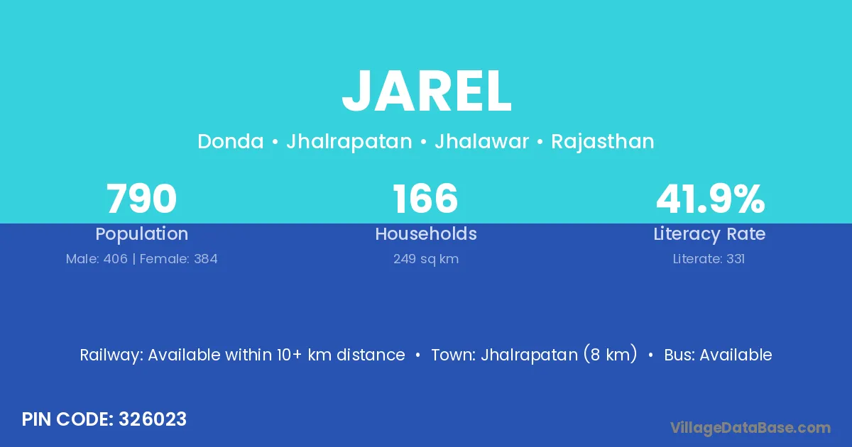
Jarel village is located in the Jhalrapatan Tehsil of the Jhalawar district in Rajasthan .

About Jarel Village

Block / Tehsil → Jhalrapatan

District → Jhalawar

State → Rajasthan

According to Census 2011 information, the village code of Jarel village is 326023.

Jarel village has a total population of 790 people, of which 406 are males and 384 are females.

The literacy rate of Jarel village is 41.90%. Male literacy stands at 55.91% and female literacy at 27.08%.

There are approximately 166 households in Jarel village.

Jhalrapatan (8 km) is the nearest town to Jarel village for major economic activities and is located approximately 8 km away.

Population of Jarel Village

The population of Jarel village is distributed between literate and illiterate residents as follows:

Population distribution of Jarel village by literacy and gender
Particulars Male Female Total
Literate 227 104 331
Illiterate 179 280 459
Total 406 384 790

Source: Census 2011

Nearby Villages

List of nearby villages around Jarel village
Village District
Mangal South Goa
Mangal Kangra
Mangal Jammu
Semli Barwani
Kalakot Damoh
Kalakot Mandsaur
Semli Mandsaur
Semli Mandsaur
Semli Mandsaur
Semli Rajgarh
Semli Rajgarh
Rooparel Rajgarh
Semli Rajgarh
Semli Shajapur
Rooparel Ajmer
Shyopur Alwar
Rooparel Banswara
Rooparel Baran
Semli Baran
Semli Bharatpur
Rooparel Bhilwara
Rooparel Bhilwara
Mangal Bundi
Semli Jhalawar
Saranga Khera Jhalawar
Bhanwarsa Jhalawar
Bhanwrasi Jhalawar
Jarel Chouki Jhalawar
Kalakot Jhalawar
Kishanpura Bhanwrasi Jhalawar
Mangal Jhalawar
Rooparel Jhalawar
Rundlao Jhalawar
Saranga Khera Jhalawar
Semli Jhalawar
Shyopur Jhalawar
Semli Jhalawar
Rooparel Jhalawar
Saranga Khera Jhalawar
Rooparel Kota
Kalakot Pali
Kalakot Pratapgarh
Semli Pratapgarh
Semli Sirohi
Rooparel Tonk
Shyopur Tonk
Mangal Thiruvarur
Mangal Tiruvannamalai
Semli Bulandshahr
Kalakot Champawat
Mangal Puruliya
Mangal Puruliya

Frequently Asked Questions

Jarel village is located in the Jhalrapatan Tehsil of the Jhalawar district in Rajasthan.
The total population is 790 people.
406 males and 384 females.
The literacy rate is 41.90%.
Male literacy rate is 55.91%, and female literacy rate is 27.08%.
There are approximately 166 houses in Jarel village.
Jhalrapatan (8 km) is the nearest town, located approximately 8 km away.

Reviews and Ratings

0.0 / 5 (0 reviews)

Reviews

No reviews yet. Be the first to review this village!

Jarel Village Statistics

Population
790
Area
249 km²
Households
166
Nearest Town :
Jhalrapatan (8 km)

Quick Information

State / UT : Rajasthan
Pincode : 326023
Total Area : 249 km²
Population : 790
Households : 166
Gram Panchayat : Donda
Nearest Town : Jhalrapatan (8 km)

Connectivity of Jarel

🚂 Railway Station

Available within 10+ km distance

🚌 Public Bus Service

Available within 5 - 10 km distance

🚌 Private Bus Service

Available within <5 km distance

Need Help?

Contact local tourism office for assistance