Welcome Back

Forgot password?
Don't have an account?
🏘️ Menu
Jhunjhunun District 0.0 / 5 (0)

Hanutpura Village Detailed Information

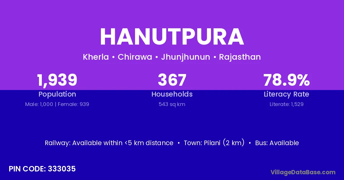
Hanutpura village is located in the Chirawa Tehsil of the Jhunjhunun district in Rajasthan .

About Hanutpura Village

Block / Tehsil → Chirawa

District → Jhunjhunun

State → Rajasthan

According to Census 2011 information, the village code of Hanutpura village is 333035.

Hanutpura village has a total population of 1,939 people, of which 1,000 are males and 939 are females.

The literacy rate of Hanutpura village is 78.86%. Male literacy stands at 81.50% and female literacy at 76.04%.

There are approximately 367 households in Hanutpura village.

Pilani (2 km) is the nearest town to Hanutpura village for major economic activities and is located approximately 2 km away.

Population of Hanutpura Village

The population of Hanutpura village is distributed between literate and illiterate residents as follows:

Population distribution of Hanutpura village by literacy and gender
Particulars Male Female Total
Literate 815 714 1,529
Illiterate 185 225 410
Total 1,000 939 1,939

Source: Census 2011

Nearby Villages

List of nearby villages around Hanutpura village
Village District
Bhoja Ka Bas Jhunjhunun
Dhandhar Gaya
Dhandhar Udhampur
Dhandhar Raisen
Dhandhar Jhunjhunun
Dhandhar Pratapgarh
Dheendhwa Aguna Jhunjhunun
Dheendhwa Athoona Jhunjhunun
Dheendhwa Bichla Jhunjhunun
Garinda Jhunjhunun
Garinda Sikar
Ghumansar Kalan Jhunjhunun
Jherli Jhunjhunun
Kherla Gurgaon
Kherla Mewat
Kherla Guna
Kherla Morena
Kherla Alwar
Kherla Alwar
Kherla Alwar
Kherla Baran
Kherla Baran
Kherla Bundi
Kherla Dausa
Kherla Jhalawar
Kherla Jhunjhunun
Kherla Karauli
Kherla Sawai Madhopur
Kulhariyon Ka Bas Jhunjhunun
Suryanagar Thane
Suryanagar Thane
Suryanagar Thane
Suryanagar Jhunjhunun
Suryanagar Nagaur
Suryanagar South Twenty Four Parganas

Frequently Asked Questions

Hanutpura village is located in the Chirawa Tehsil of the Jhunjhunun district in Rajasthan.
The total population is 1,939 people.
1,000 males and 939 females.
The literacy rate is 78.86%.
Male literacy rate is 81.50%, and female literacy rate is 76.04%.
There are approximately 367 houses in Hanutpura village.
Pilani (2 km) is the nearest town, located approximately 2 km away.

Reviews and Ratings

0.0 / 5 (0 reviews)

Reviews

No reviews yet. Be the first to review this village!

Hanutpura Village Statistics

Population
1939
Area
543 km²
Households
367
Nearest Town :
Pilani (2 km)

Quick Information

State / UT : Rajasthan
Pincode : 333035
Total Area : 543 km²
Population : 1939
Households : 367
Gram Panchayat : Kherla
Nearest Town : Pilani (2 km)

Connectivity of Hanutpura

🚂 Railway Station

Available within <5 km distance

🚌 Public Bus Service

Available within <5 km distance

🚌 Private Bus Service

Available within <5 km distance

Need Help?

Contact local tourism office for assistance