Welcome Back

Forgot password?
Don't have an account?
🏘️ Menu
Karauli District 0.0 / 5 (0)

Hariya Ka Mandir Village Detailed Information

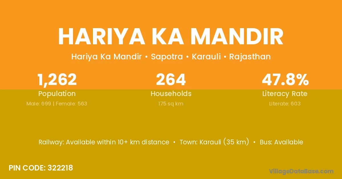
Hariya Ka Mandir village is located in the Sapotra Tehsil of the Karauli district in Rajasthan .

About Hariya Ka Mandir Village

Block / Tehsil → Sapotra

District → Karauli

State → Rajasthan

According to Census 2011 information, the village code of Hariya Ka Mandir village is 322218.

Hariya Ka Mandir village has a total population of 1,262 people, of which 699 are males and 563 are females.

The literacy rate of Hariya Ka Mandir village is 47.78%. Male literacy stands at 58.80% and female literacy at 34.10%.

There are approximately 264 households in Hariya Ka Mandir village.

Karauli (35 km) is the nearest town to Hariya Ka Mandir village for major economic activities and is located approximately 35 km away.

Population of Hariya Ka Mandir Village

The population of Hariya Ka Mandir village is distributed between literate and illiterate residents as follows:

Population distribution of Hariya Ka Mandir village by literacy and gender
Particulars Male Female Total
Literate 411 192 603
Illiterate 288 371 659
Total 699 563 1,262

Source: Census 2011

Nearby Villages

List of nearby villages around Hariya Ka Mandir village
Village District
Gothra Kishanganj
Mangrol Banas Kantha
Mangrol Bharuch
Mangrol Bharuch
Mangrol Junagadh
Mangrol Narmada
Mangrol Navsari
Gopipura Panch Mahals
Mangrol Surat
Mangrol Vadodara
Gothra Bhiwani
Gothra Bhiwani
Gothra Mandi
Mangrol Mandi
Mangrol Dhar
Mangrol Hoshangabad
Suratpura Khargone
Mangrol Morena
Mangrol Neemuch
Mangrol Raisen
Mangrol Raisen
Mangrol Ratlam
Gothra Sheopur
Gothra Sheopur
Mangrol Shivpuri
Gothra Ajmer
Kali Doongri Ajmer
Gothra Alwar
Gopipura Alwar
Gothra Alwar
Bapoti Baran
Gothra Bharatpur
Gothra Bharatpur
Keeratpura Bhilwara
Gopipura Bhilwara
Gothra Bhilwara
Gothra Bhilwara
Keeratpura Bhilwara
Gothra Bundi
Gothra Bundi
Keeratpura Chittaurgarh
Suratpura Chittaurgarh
Gothra Chittaurgarh
Mangrol Chittaurgarh
Suratpura Churu
Suratpura Churu
Keeratpura Dausa
Gothra Dausa
Suratpura Dausa
Mangrol Dhaulpur
Gothra Dungarpur
Gopipura Jaipur
Gopipura Jaipur
Gothra Jaipur
Keeratpura Jaipur
Suratpura Jaipur
Gothra Jhunjhunun
Gothra Jhunjhunun
Keeratpura Karauli
Mangrol Karauli
Gothra Karauli
Baluapura Karauli
Bapoti Karauli
Gopipura Karauli
Gothra Karauli
Kali Doongri Karauli
Keeratpura Karauli
Lokeshnagar Karauli
Mangrol Karauli
Mijhaura Karauli
Ratanapura Karauli
Suratpura Karauli
Gothra Nagaur
Suratpura Nagaur
Gothra Nagaur
Suratpura Nagaur
Gothra Pratapgarh
Gothra Pratapgarh
Mangrol Pratapgarh
Gothra Pratapgarh
Suratpura Rajsamand
Suratpura Rajsamand
Gothra Sawai Madhopur
Mangrol Sawai Madhopur
Gothra Sawai Madhopur
Keeratpura Sawai Madhopur
Gothra Sawai Madhopur
Gopipura Tonk
Gothra Tonk
Kali Doongri Udaipur
Suratpura Udaipur
Mangrol Allahabad
Gothra Baghpat
Mijhaura Gonda
Gopipura Udham Singh Nagar

Frequently Asked Questions

Hariya Ka Mandir village is located in the Sapotra Tehsil of the Karauli district in Rajasthan.
The total population is 1,262 people.
699 males and 563 females.
The literacy rate is 47.78%.
Male literacy rate is 58.80%, and female literacy rate is 34.10%.
There are approximately 264 houses in Hariya Ka Mandir village.
Karauli (35 km) is the nearest town, located approximately 35 km away.

Reviews and Ratings

0.0 / 5 (0 reviews)

Reviews

No reviews yet. Be the first to review this village!

Hariya Ka Mandir Village Statistics

Population
1262
Area
175 km²
Households
264
Nearest Town :
Karauli (35 km)

Quick Information

State / UT : Rajasthan
Pincode : 322218
Total Area : 175 km²
Population : 1262
Households : 264
Gram Panchayat : Hariya Ka Mandir
Nearest Town : Karauli (35 km)

Connectivity of Hariya Ka Mandir

🚂 Railway Station

Available within 10+ km distance

🚌 Public Bus Service

Available within <5 km distance

🚌 Private Bus Service

Available within <5 km distance

Need Help?

Contact local tourism office for assistance