Welcome Back

Forgot password?
Don't have an account?
🏘️ Menu
Agra District 0.0 / 5 (0)

Ratauti Village Detailed Information

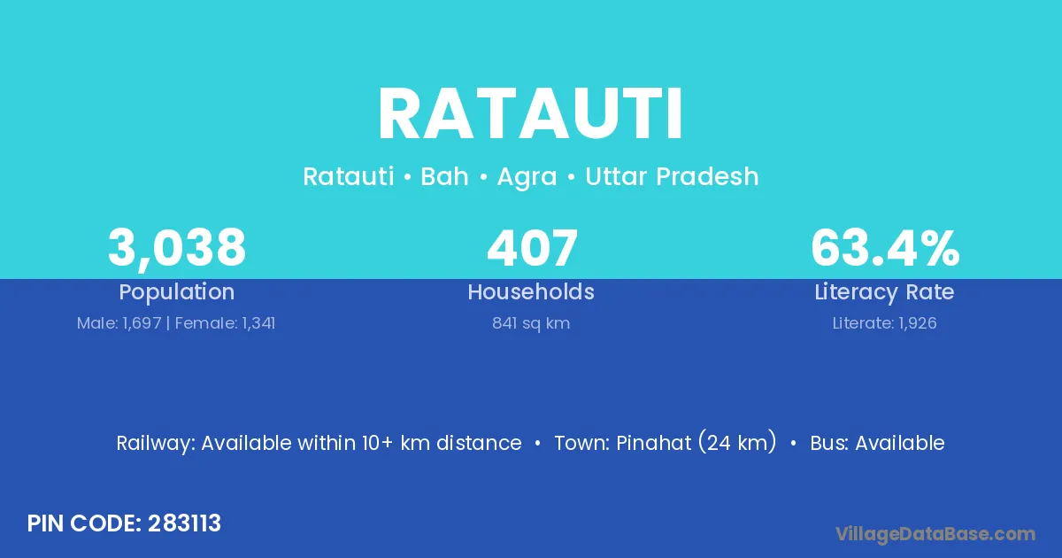
Ratauti village is located in the Bah Tehsil of the Agra district in Uttar Pradesh .

About Ratauti Village

Block / Tehsil → Bah

District → Agra

State → Uttar Pradesh

According to Census 2011 information, the village code of Ratauti village is 283113.

Ratauti village has a total population of 3,038 people, of which 1,697 are males and 1,341 are females.

The literacy rate of Ratauti village is 63.40%. Male literacy stands at 73.25% and female literacy at 50.93%.

There are approximately 407 households in Ratauti village.

Pinahat (24 km) is the nearest town to Ratauti village for major economic activities and is located approximately 24 km away.

Population of Ratauti Village

The population of Ratauti village is distributed between literate and illiterate residents as follows:

Population distribution of Ratauti village by literacy and gender
Particulars Male Female Total
Literate 1,243 683 1,926
Illiterate 454 658 1,112
Total 1,697 1,341 3,038

Source: Census 2011

Nearby Villages

List of nearby villages around Ratauti village
Village District
Rajaura Aurangabad
Rajaura Begusarai
Rajaura Begusarai
Rajaura Darbhanga
Rajaura Gaya
Balai Mewat
Balai Palwal
Rajaura Chhatarpur
Bhitari Datia
Bhitari Gwalior
Bhitari Panna
Bhitari Rewa
Bhitari Rewa
Bhitari Satna
Bhitari Satna
Bhitari Satna
Rajaura Sheopur
Rajaura Shivpuri
Bhitari Sidhi
Bhitari Sidhi
Balai Barmer
Balai Agra
Bhitari Agra
Bhonigapura Agra
Gajoura Agra
Ladhavapura Agra
Nagla Dalel Agra
Pahirjaura Agra
Rajaura Agra
Rithai Agra
Siahipura Agra
Torahpall Agra
Bhitari Azamgarh
Bhitari Azamgarh
Balai Azamgarh
Bhitari Chandauli
Bhitari Chitrakoot
Rajaura Faizabad
Bhitari Faizabad
Rajaura Firozabad
Bhitari Jalaun
Bhitari Jaunpur
Rajaura Kheri
Rajaura Mahoba
Bhitari Pratapgarh
Bhitari Rae Bareli
Rajaura Rampur
Bhitari Sonbhadra
Balai Unnao
Bhitari Varanasi
Balai Champawat

Frequently Asked Questions

Ratauti village is located in the Bah Tehsil of the Agra district in Uttar Pradesh.
The total population is 3,038 people.
1,697 males and 1,341 females.
The literacy rate is 63.40%.
Male literacy rate is 73.25%, and female literacy rate is 50.93%.
There are approximately 407 houses in Ratauti village.
Pinahat (24 km) is the nearest town, located approximately 24 km away.

Reviews and Ratings

0.0 / 5 (0 reviews)

Reviews

No reviews yet. Be the first to review this village!

Ratauti Village Statistics

Population
3038
Area
841 km²
Households
407
Nearest Town :
Pinahat (24 km)

Quick Information

State / UT : Uttar Pradesh
Pincode : 283113
Total Area : 841 km²
Population : 3038
Households : 407
Gram Panchayat : Ratauti
Nearest Town : Pinahat (24 km)

Connectivity of Ratauti

🚂 Railway Station

Available within 10+ km distance

🚌 Public Bus Service

Available within <5 km distance

🚌 Private Bus Service

Available

Need Help?

Contact local tourism office for assistance