Welcome Back

Forgot password?
Don't have an account?
🏘️ Menu
Mau District 0.0 / 5 (0)

Sarfora Village Detailed Information

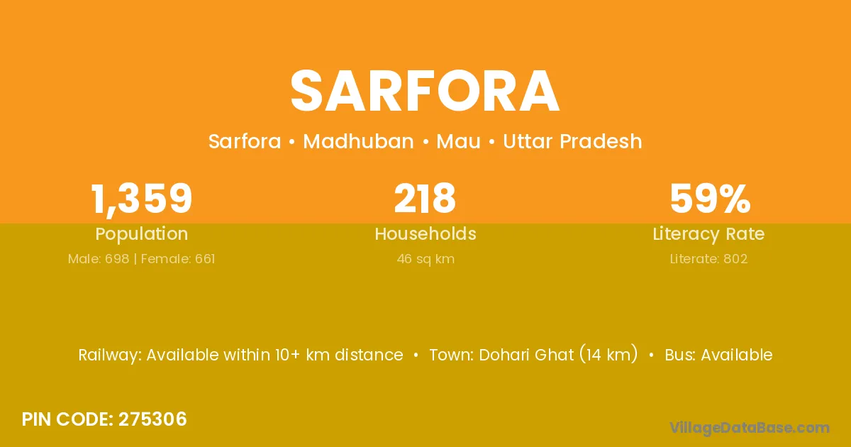
Sarfora village is located in the Madhuban Tehsil of the Mau district in Uttar Pradesh .

About Sarfora Village

Block / Tehsil → Madhuban

District → Mau

State → Uttar Pradesh

According to Census 2011 information, the village code of Sarfora village is 275306.

Sarfora village has a total population of 1,359 people, of which 698 are males and 661 are females.

The literacy rate of Sarfora village is 59.01%. Male literacy stands at 67.77% and female literacy at 49.77%.

There are approximately 218 households in Sarfora village.

Dohari Ghat (14 km) is the nearest town to Sarfora village for major economic activities and is located approximately 14 km away.

Population of Sarfora Village

The population of Sarfora village is distributed between literate and illiterate residents as follows:

Population distribution of Sarfora village by literacy and gender
Particulars Male Female Total
Literate 473 329 802
Illiterate 225 332 557
Total 698 661 1,359

Source: Census 2011

Nearby Villages

List of nearby villages around Sarfora village
Village District
Bhainsaha Bhojpur
Bhainsaha Rohtas
Parsiya Rohtas
Ibrahimabad Vaishali
Parsiya Surguja
Parsiya Deoghar
Parsiya Deoghar
Parsiya Deoghar
Parsiya Godda
Parsiya Godda
Parsiya Palamu
Chakara Chhindwara
Parsiya Jabalpur
Chakara Khandwa
Parsiya Rewa
Parsiya Satna
Chakara Satna
Bhainsaha Shahdol
Chakara Shivpuri
Chakara Bhandara
Chakara Kendrapara
Parsiya Azamgarh
Parsiya Bahraich
Ibrahimabad Bara Banki
Ibrahimabad Bijnor
Parsiya Chandauli
Chakara Chandauli
Bhainsaha Deoria
Mitanpur Faizabad
Bhainsaha Gonda
Parsiya Gorakhpur
Ibrahimabad Jaunpur
Chakara Jhansi
Mitanpur Kanpur Nagar
Ibrahimabad Kaushambi
Parsiya Kheri
Parsiya Kheri
Parsiya Kushinagar
Bhainsaha Kushinagar
Mitanpur Mahamaya Nagar
Ibrahimabad Mau
Bhainsaha Mau
Chakara Mau
Ibrahimabad Mau
Jiwapar Mau
Kast Sitaram Mau
Khazuha Mau
Mitanpur Mau
Parsiya Mau
Patjiwa Mau
Roshan Pur Mau
Suraj Pur Mau
Chakara Mirzapur
Bhainsaha Siddharthnagar
Khazuha Sitapur
Chakara Sonbhadra
Ibrahimabad Unnao
Parsiya Puruliya
Parsiya Puruliya

Frequently Asked Questions

Sarfora village is located in the Madhuban Tehsil of the Mau district in Uttar Pradesh.
The total population is 1,359 people.
698 males and 661 females.
The literacy rate is 59.01%.
Male literacy rate is 67.77%, and female literacy rate is 49.77%.
There are approximately 218 houses in Sarfora village.
Dohari Ghat (14 km) is the nearest town, located approximately 14 km away.

Reviews and Ratings

0.0 / 5 (0 reviews)

Reviews

No reviews yet. Be the first to review this village!

Sarfora Village Statistics

Population
1359
Area
46 km²
Households
218
Nearest Town :
Dohari Ghat (14 km)

Quick Information

State / UT : Uttar Pradesh
Pincode : 275306
Total Area : 46 km²
Population : 1359
Households : 218
Gram Panchayat : Sarfora
Nearest Town : Dohari Ghat (14 km)

Connectivity of Sarfora

🚂 Railway Station

Available within 10+ km distance

🚌 Public Bus Service

Available within <5 km distance

🚌 Private Bus Service

Available within <5 km distance

Need Help?

Contact local tourism office for assistance