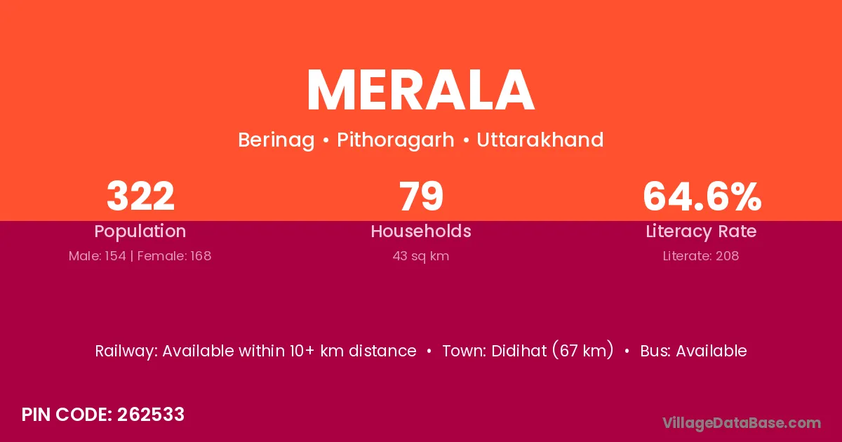
Merala village is located in the Berinag Tehsil of the Pithoragarh district in Uttarakhand .
Block / Tehsil → Berinag
District → Pithoragarh
State → Uttarakhand
According to Census 2011 information, the village code of Merala village is 262533.
Merala village has a total population of 322 people, of which 154 are males and 168 are females.
The literacy rate of Merala village is 64.60%. Male literacy stands at 69.48% and female literacy at 60.12%.
There are approximately 79 households in Merala village.
Didihat (67 km) is the nearest town to Merala village for major economic activities and is located approximately 67 km away.
The population of Merala village is distributed between literate and illiterate residents as follows:
| Particulars | Male | Female | Total |
|---|---|---|---|
| Literate | 107 | 101 | 208 |
| Illiterate | 47 | 67 | 114 |
| Total | 154 | 168 | 322 |
Source: Census 2011
| Village | District |
|---|---|
| Dwali Kholi | Pithoragarh |
| Haliya Dob | Pithoragarh |
| Hirmoli | Pithoragarh |
| Karala Mahar | Pithoragarh |
| Khola Gaon | Pithoragarh |
| Kuri | Rohtas |
| Kuri | Bharuch |
| Kuri | Kangra |
| Kuri | Khunti |
| Kuri | Saraikela Kharsawan |
| Kuri | Barmer |
| Kuri | Jodhpur |
| Kuri | Gonda |
| Kuri | Gorakhpur |
| Kuri | Jyotiba Phule Nagar |
| Kuri | Meerut |
| Kuri | Moradabad |
| Kuri | Shahjahanpur |
| Kuri | Unnao |
| Kuri | Varanasi |
| Kuri | Pithoragarh |
| Kuri | Tehri Garhwal |
| Makhauli | Kanpur Nagar |
| Makhauli | Pithoragarh |
| Nagila Gaon | Pithoragarh |
| Papsyari | Pithoragarh |
| Putha Gaon | Pithoragarh |
| Tora Thal | Pithoragarh |
No reviews yet. Be the first to review this village!
Available within 10+ km distance
Available within 10+ km distance
Available within 10+ km distance