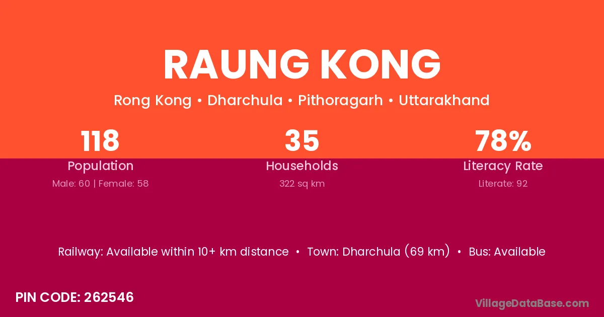
Raung Kong village is located in the Dharchula Tehsil of the Pithoragarh district in Uttarakhand .
Block / Tehsil → Dharchula
District → Pithoragarh
State → Uttarakhand
According to Census 2011 information, the village code of Raung Kong village is 262546.
Raung Kong village has a total population of 118 people, of which 60 are males and 58 are females.
The literacy rate of Raung Kong village is 77.97%. Male literacy stands at 90.00% and female literacy at 65.52%.
There are approximately 35 households in Raung Kong village.
Dharchula (69 km) is the nearest town to Raung Kong village for major economic activities and is located approximately 69 km away.
The population of Raung Kong village is distributed between literate and illiterate residents as follows:
| Particulars | Male | Female | Total |
|---|---|---|---|
| Literate | 54 | 38 | 92 |
| Illiterate | 6 | 20 | 26 |
| Total | 60 | 58 | 118 |
Source: Census 2011
| Village | District |
|---|---|
| Bundi | Baran |
| Bundi | Tonk |
| Bundi | Pithoragarh |
| Bung Bung | Pithoragarh |
| Chal | Bargarh |
| Chal | Pithoragarh |
| Galagar | Pithoragarh |
| Garbyang | Pithoragarh |
| Gunji | Belgaum |
| Gunji | Damoh |
| Gunji | Narsimhapur |
| Gunji | Amravati |
| Gunji | Koraput |
| Gunji | Pithoragarh |
| Kuti | Chatra |
| Kuti | Dausa |
| Kuti | Pithoragarh |
| Nagling | Pithoragarh |
| Napalachchu | Pithoragarh |
| Navi | Solan |
| Navi | Pithoragarh |
| Sela | Chamba |
| Sela | Chhatarpur |
| Sela | Barmer |
| Sela | Barmer |
| Sela | Pali |
| Sela | Bijnor |
| Sela | Pithoragarh |
| Sela | Pithoragarh |
No reviews yet. Be the first to review this village!
Available within 10+ km distance
Available within 10+ km distance
Available within 10+ km distance